Dogwood Trail Alder Trail Loop Keil Trail Leif Erikson Drive Wildwood Trail Hike Forest Park Portland Oregon
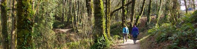
Forest Park is a wonderful place to take a short hike in Portland. For a 5-trail, four-season outing, check out Dogwood Trail – Alder Trail Loop, which actually uses Keil Trail, Dogwood Trail, Leif Erikson Drive, Alder Trail, and Wildwood Trail to form a 2.8-mile circuit with just over 400 feet of elevation change. In the summer, these Forest Park trails offer cooling shade. In the fall,... Read more.
OK! Add to trails I’ve hiked
OK! Add to trails I want to hike
Tagged with · Forest Park · Free Trails · Northwest Portland · Tualatin Mountains · West Hills of Portland
Distance: 2.8 miles · Elevation change: 410 feet
By: Published: Last updated: October 20, 2018
Haystack Trail Mount Shasta Hike Klamath National Forest The Haystack Butte California
The Haystack is a diminutive volcanic dome with great views of the enormous, snowy mass of Mount Shasta. Haystack Trail presents a 2.55-mile lollipop loop hike that tours the Haystack's summit plateau, boasting broad views in all directions that include Mount Shasta, the Klamath Mountains, and Shasta Valley. This high desert hike passes through juniper and sage that get embellished by spring... Read more.
OK! Add to trails I’ve hiked
OK! Add to trails I want to hike
Tagged with · Buttes · Free Trails · Klamath National Forest · Montague · Mount Shasta · Weed
Distance: 2.55 miles · Elevation change: 375 feet
By: Published: Last updated: February 4, 2019
Las Virgenes View Trail Las Virgenes Valley Hike Malibu Canyon Las Virgenes View Park Calabasas California Santa Monica Mountains
Las Virgenes View Park preserves nearly 700 acres of the Santa Monica Mountains adjacent to Malibu Creek State Park. The park has one established trail, Las Virgenes View Trail, which rises to a panorama-boasting ridge. The trail traverses grasslands and oak woodlands near Las Virgenes Road and then runs up a canyon to a ridge where it forms a small loop with mountain views in all... Read more.
By: Published: Last updated: January 11, 2019
Heartbreak Hill Trail Santa Monica Mountains Hike Liberty Canyon Agoura Hills California
The heart pounding on Heartbreak Hill comes from the heavy dose of elevation on this short trail, which climbs 600 feet in a little over a mile. The trail is steep from the start, but does taper out before a rapid rise to Heartbreak Ridge, just below a summit crest. The hike is easy-to-reach, setting out from Agoura Road near the Liberty Canyon Exit of the 101 Freeway. The top of the hike... Read more.
OK! Add to trails I’ve hiked
OK! Add to trails I want to hike
Tagged with · Agoura Hills · Free Trails · Dog-Friendly Trails · Santa Monica Mountains
Distance: 2.1 miles · Elevation change: 600 feet
By: Published: Last updated: January 11, 2019
Anza Loop Trail Santa Monica Mountains Hike Calabasas Agoura Hills California
In a rolling, grassy stretch of the Santa Monica Mountains near the 101 Freeway, Anza Loop Trail plots a course through history. Pause along the trail to study panels and plaques about the past - or just breeze through the loop and enjoy the present sights and sounds. Like Anza-Borrego Desert State Park, Anza Loop Trail takes its name from Juan Bautista de Anza who led an expedition up... Read more.
By: Published: Last updated: January 20, 2021
Calabasas Stairs Anza Loop Trail Calabasas California Concrete Steps Workout Hike
Do you want to combine a hike with a stair workout? If the answer is yes, head for the Calabasas Stairs, a long, straight flight of 375 steps that climb a slope in the Santa Monica Mountains below a Calabasas neighborhood. It is a 0.6-mile hike from Calabasas Road (just off Highway 101) to the base of the steps. Venturing to the top of the steps and back to the road is 1.4 miles round trip... Read more.
By: Published: Last updated: January 20, 2021
Columbia Rock Yosemite National Park Columbia Rock Viewpoint Yosemite Falls Trail Hike Yosemite Valley California
Yosemite Valley looks great from the bottom up, the top down, and even the middle out. For this neither-up-nor-down view over Yosemite Valley, visit Columbia Rock, a viewpoint on Yosemite Falls Trail perched about thousand feet up the north wall of Yosemite Valley. The hike from Camp 4 up to Columbia Rock is 2.2 miles round trip with 985 feet of elevation change. Of course, continuing up... Read more.
OK! Add to trails I’ve hiked
OK! Add to trails I want to hike
Tagged with · National Parks · Yosemite Valley
Distance: 2.2 miles · Elevation change: 985 feet
By: Published: Last updated: January 31, 2018
Wildcat Falls Trail Yosemite National Park Wildcat Creek Falls Path Waterfall Hike California
Is it possible to have a Yosemite National Park waterfall all to yourself? Yes! The odds of waterfall solitude are pretty low when you go to Yosemite Falls, Bridalveil Fall, or Vernal Fall and Nevada Fall along the Mist Trail, but unheralded Wildcat Falls is different. Although this multi-tier waterfall is about 650 feet tall, only the bottom 50-foot tall cascade at the base of Wildcat Falls... Read more.
OK! Add to trails I’ve hiked
OK! Add to trails I want to hike
Tagged with · National Parks · Waterfalls
Distance: 0.15 miles · Elevation change: 15 feet
By: Published: Last updated: September 10, 2018
Yosemite Falls Trail Yosemite National Park Upper Yosemite Fall Hike Yosemite Valley California
Yosemite Falls is incredibly beautiful and incredibly big. It is the tallest waterfall in North America, the 5th tallest waterfall in the world, and a star along the north wall of Yosemite Valley. Hiking to Yosemite Falls is one of the greatest things visitors can do in Yosemite National Park. Yosemite Falls drops a total of 2,425 feet, beginning with the cliff-leaping 1,430-foot Upper... Read more.
OK! Add to trails I’ve hiked
OK! Add to trails I want to hike
Tagged with · National Parks · Waterfalls · Yosemite Valley
Distance: 7 miles · Elevation change: 2715 feet
By: Published: Last updated: January 31, 2018
Happy Isles Trail Yosemite National Park The Happy Isles Merced River Hike Yosemite Valley California
Near the amazing hiking trails in Yosemite Valley is the designed-to-be-delightful Happy Isles Trail. The easy 3/4 of a mile walk at Happy Isles explores a pair of small islands in the Merced River at the east end of Yosemite Valley. While the trail doesn't feature a show-stopping attraction (like Lower Yosemite Fall Trail), the Happy Isles live up to their name – a pleasant and happy... Read more.
OK! Add to trails I’ve hiked
OK! Add to trails I want to hike
Tagged with · National Parks · Wheelchair-Friendly · Yosemite Valley
Distance: 0.75 miles · Elevation change: 50 feet
By: Published: Last updated: September 10, 2018