Strawberry Peak Trail to Strawberry Meadow Hike San Gabriel Mountains National Monument Strawberry Potrero Angeles National Forest
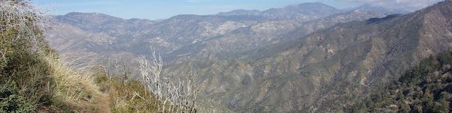
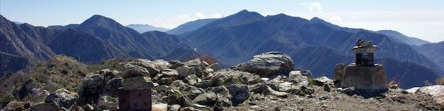
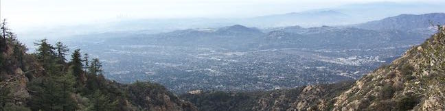
Strawberry Meadow is an enticing area tucked away on the north side of Strawberry Peak below a massive granite cliff face. Walk into Strawberry Meadow and you might easily feel like you are somewhere in the Sierra Nevada Mountains, instead of hiking in the San Gabriel Mountains near Los Angeles. Find Strawberry Meadow next to a junction between Strawberry Peak Trail and Colby Canyon... Read more.
By: Published: Last updated: May 13, 2025
Josephine Peak Hike Colby Canyon Trail San Gabriel Mountains National Monument Angeles National Forest Josephine Saddle Josephine Peak Road
Want to hike to a mile-high summit in the San Gabriel Mountains with grand views over Los Angeles? Set your aim for Josephine Peak in the front range of the San Gabriel Mountains next to Strawberry Peak. Colby Canyon Trail offers a scenic route to the summit, traveling from Angeles Crest Highway up a withdrawn canyon to Josephine Saddle, a dip in the ridgeline west of Strawberry Peak. ... Read more.
By: Published: Last updated: May 13, 2025
Rattlesnake Flats Trail - Badger Trail - Bluff Trail Loop Montaña de Oro State Park Hike
Completely resurfaced to be wheelchair-friendly, the Bluff Trail in Montaña de Oro State Park is one of the most pleasant coastal trails in California. Once you have hiked the Bluff Trail, you will probably want to see it again (and again and again). Revisit the Bluff Trail and get just a bit more elevation by creating a loop with Bluff Trail, Badger Trail, and Rattlesnake Flats Trail. ... Read more.
OK! Add to trails I’ve hiked
OK! Remove from my hikes
Tagged with · California State Parks · Free Trails · Los Osos · Ocean Views · Tide Pools · Montaña de Oro State Park
Distance: 1.65 miles · Elevation change: 150 feet
By: Published: Last updated: May 11, 2017
China Flat Trail Simi Peak Trail Simi Hills hike Oak Park California China Flat Dead Cow Trail Suicide Trail Loop Oak Savanna
Looking up at the orange sandstone outcroppings on the rugged slopes of the Simi Hills, you would hardly expect the terrain above to host a peaceful oak savanna. Walk through this grassy area shade by tall oaks to ascend to Simi Peak, the highest point in a mountain range that spans the boundary between Ventura County and Los Angeles County just north of the 101 Freeway. Simi Peak is 2,403... Read more.
OK! Add to trails I’ve hiked
OK! Add to trails I want to hike
Tagged with · Conejo Valley · Free Trails · Oak Park · Simi Hills · Summits · Dog-Friendly Trails · Mountain Biking Trails
Distance: 6.2 miles · Elevation change: 1090 feet
By: Published: Last updated: May 13, 2025
Mount Lowe Road Sunset Ridge Trail to Cape of Good Hope Mount Lowe Railway Echo Mountain Ruins San Gabriel Mountains Hike Los Angeles National Forest California
Starting near the base of the San Gabriel Mountains in Altadena, Mount Lowe Road is an 8.9-mile long partially paved trail rising up the range to an intersection with Mount Wilson Red Box Road near the summit of Mount Wilson. Of course, you don't have to go that full distance on a hike up Mount Lowe Road. Sunset Ridge Trail intersects and parallels the bottom of Mount Lowe Road and is even... Read more.
By: Published: Last updated: May 13, 2025
Castle Canyon Trail to Inspiration Point Echo Mountain Ruins Mount Lowe Road Mount Lowe Railway San Gabriel Mountains Hike Los Angeles National Forest California
Castle Canyon Trail is a dirt single track that connects the ruins at Echo Mountain to Inspiration Point, which was a premier vista point for the resort's visitors and still offers sweeping views. In the past, a railway took Echo Mountain's guests up into the mountains, but now leg power is required to get up Castle Canyon Trail to Inspiration Point. The single track is gradual when it... Read more.
By: Published: Last updated: May 13, 2025
Devils Punchbowl Falls Arthur's Pass National Park Hike Devils Punchbowl Walking Track Arthur's Pass Village Hiking Track Devils Punchbowl Waterfall New Zealand Devil's Punchbowl
Devils Punchbowl Falls is a star attraction in Arthur's Pass National Park. The dynamic waterfall plunges 131 meters into a canyon near Arthur's Pass Village. The area's Māori named the waterfall Hinekakai, taking inspiration from its beautiful threads of water. Visitors can reach the waterfall on a 2-kilometer (1.4-mile) round trip walk beginning from Arthur's Pass Village. Devils... Read more.
By: Published: Last updated: May 6, 2017
Otira Valley Track Arthur's Pass National Park Hike Arthur's Pass Village Hiking Track New Zealand
Just over the north side of Arthur's Pass and 5 kilometers from Arthur's Pass Village, you'll find Otira Valley Track, which ascends a trough-shaped valley off the west side of the pass. The track ends at Otira River Footbridge. Under normal circumstances, a bridge would be an odd place to end a hike (since a bridge lead to something on the other side). The route beyond Otira River... Read more.
OK! Add to trails I’ve hiked
OK! Add to trails I want to hike
Tagged with · Arthur's Pass Village · Creeks · Free Trails · New Zealand Department of Conservation · New Zealand National Parks · Arthur's Pass National Park
Distance: 3.8 kilometers / 2.35 miles · Elevation change: 125 meters / 410 feet
By: Published: Last updated: May 6, 2017
Bealey Chasm Walk Arthur's Pass National Park Hike Bealey River Hiking Track Bealey Valley Track Footbridge Arthur's Pass Village New Zealand
North of Arthur's Pass Village, Bealey River passes through a narrow gorge, creating a mix of tumbling white water and blue pools. A footbridge on Bealey Valley Track crosses over this point on the river, called Bealey Chasm. Visit the chasm on a short walk beginning from State Highway 73. Bealey Chasm Walk starts with a short section of Arthur's Pass Walking Track and connects to Bealey... Read more.
OK! Add to trails I’ve hiked
OK! Add to trails I want to hike
Tagged with · Arthur's Pass Village · Creeks · Free Trails · New Zealand Department of Conservation · New Zealand National Parks · Arthur's Pass National Park
Distance: 0.65 kilometers / 0.4 miles · Elevation change: 12 meters / 40 feet
By: Published: Last updated: May 6, 2017
Old Coach Road Walk Arthur's Pass National Park Hike Greyneys Shelter Arthur's Pass Hiking Track New Zealand
This mostly unremarkable woodland walk explores the forest a few kilometers south of Arthur's Pass Village. Much of the track follows an old coach road that went to Arthur's Pass so the walk provides a history lesson on the area's earlier travelers. The easy walk is 1 to 1.4 kilometers long, starting and ending at Greynes Shelter Campground. With just 15 meters of elevation change along... Read more.
OK! Add to trails I’ve hiked
OK! Add to trails I want to hike
Tagged with · Arthur's Pass Village · Free Trails · New Zealand Department of Conservation · New Zealand National Parks · Arthur's Pass National Park
Distance: 1.4 kilometers / 0.9 miles · Elevation change: 15 meters / 50 feet
By: Published: Last updated: May 6, 2017