Stenner Creek Trail Red Dog Trail Poly Canyon Road Loop San Luis Obispo Eucs Hike
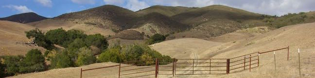
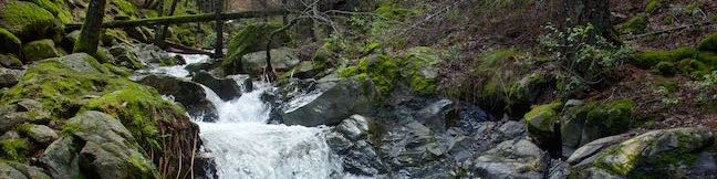
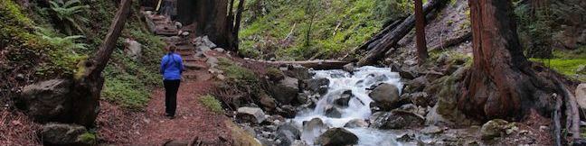
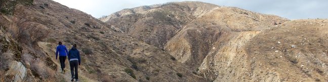
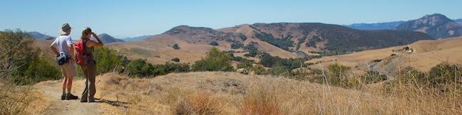
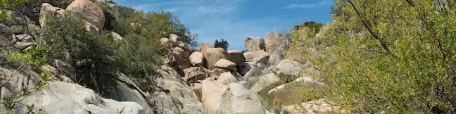
Above Stenner Creek Road near the Cal Poly Campus, a freestyle bike course is hidden within a eucalyptus grove. The easiest route to The Eucs is to head up and back on Stenner Creek Trail. For a longer hike that explores neighboring grassland on slopes below the Santa Lucia Mountains, consider this 4.25-mile loop with 550 feet of elevation change. This hike takes Stenner Creek Trail up to the Eucs and then continues on Red Dog Trail, which sets out across grassy ridges and descends to Poly Canyon Road, a dirt road back to the beginning of Stenner Creek Trail. ...Read more.
My Hikes: Completed hikeA green icon of shows a picture of a landscape with a check mark in the upper right corner, signifying that this is a hike you would like to put on your completed list.OK! Add to trails I've hiked
My Hikes: Want to hikeA green icon of shows a picture of a landscape with a heart in the upper right corner, signifying that this is a hike you would like to put on your to-do list.OK! Add to trails I want to hike
TagsA green icon depicting a tags represents a list of words and phrases that this content is tagged with Tagged with · Cal Poly · Creeks · Free Trails · Santa Lucia Mountains
Hike DistanceA green icon of a hiker used to label information about the length of the hike Distance: 4.25 miles · Elevation change: 550 feet
By: Published: Last updated: December 5, 2025
Ediza Lake Ansel Adams Wilderness Inyo National Forest Mammoth Lakes Eastern Sierra Nevada Mountains California Shadow Creek Trail Ediza Lake Hike
With high summit-reflecting waters, Ediza Lake is beautiful to behold. The lake is wrapped by meadows and trees and sports massive views of Mount Ritter and Banner Peak, making it a popular destination for hikers in the Ansel Adams Wilderness of Inyo National Forest. Starting from Agnew Meadows near Mammoth Lakes, Ediza Lake is reachable on a rewarding full day hike of over 14 miles round trip with 1,250 feet of elevation change. ...Read more.
My Hikes: Completed hikeA green icon of shows a picture of a landscape with a check mark in the upper right corner, signifying that this is a hike you would like to put on your completed list.OK! Add to trails I've hiked
My Hikes: Want to hikeA green icon of shows a picture of a landscape with a heart in the upper right corner, signifying that this is a hike you would like to put on your to-do list.OK! Add to trails I want to hike
TagsA green icon depicting a tags represents a list of words and phrases that this content is tagged with Tagged with · Ansel Adams Wilderness · Creeks · John Muir Trail · Lakes · Mammoth Lakes
Hike DistanceA green icon of a hiker used to label information about the length of the hike Distance: 15 miles · Elevation change: 1250 feet
By: Published: Last updated: December 5, 2025
Shadow Lake Ansel Adams Wilderness Inyo National Forest Mammoth Lakes Eastern Sierra Nevada Mountains California Shadow Creek Trail River Trail
Get ready for Shadow Lake to step out of the shadows on this scenic hike in the Ansel Adams Wilderness of Inyo National Forest. Shadow Lake is a beautiful mountain lake on Shadow Creek Trail about halfway between the trailhead at Agnew Meadows and Ediza Lake, a popular destination for backpackers and folks committing to a day hike of over 14 miles. ...Read more.
My Hikes: Completed hikeA green icon of shows a picture of a landscape with a check mark in the upper right corner, signifying that this is a hike you would like to put on your completed list.OK! Add to trails I've hiked
My Hikes: Want to hikeA green icon of shows a picture of a landscape with a heart in the upper right corner, signifying that this is a hike you would like to put on your to-do list.OK! Add to trails I want to hike
TagsA green icon depicting a tags represents a list of words and phrases that this content is tagged with Tagged with · Ansel Adams Wilderness · Creeks · John Muir Trail · Lakes · Mammoth Lakes · Pacific Crest Trail
Hike DistanceA green icon of a hiker used to label information about the length of the hike Distance: 8.5 miles · Elevation change: 750 feet
By: Published: Last updated: December 5, 2025
Root Creek Trail Castle Crags State Park hike Northern California
Root Creek Trail presents an easy 2.2-mile round trip hike, starting in Castle Crags State Park. Most of the trail is wheelchair-friendly, until it passes into Castle Crags Wilderness in Shasta-Trinity National Forest where the trail gets just a bit less maintained on the final push to Root Creek. When you reach the creek, you can relax and watch tumbling water cascade past mossy boulders and trees. ...Read more.
My Hikes: Completed hikeA green icon of shows a picture of a landscape with a check mark in the upper right corner, signifying that this is a hike you would like to put on your completed list.OK! Add to trails I've hiked
My Hikes: Want to hikeA green icon of shows a picture of a landscape with a heart in the upper right corner, signifying that this is a hike you would like to put on your to-do list.OK! Add to trails I want to hike
TagsA green icon depicting a tags represents a list of words and phrases that this content is tagged with Tagged with · California State Parks · Castle Crags State Park · Castle Crags Wilderness · Creeks · Pacific Crest Trail · Shasta-Trinity National Forest · Wheelchair-Friendly
Hike DistanceA green icon of a hiker used to label information about the length of the hike Distance: 2.2 miles · Elevation change: 80 feet
By: Published: Last updated: December 5, 2025
Coon Creek Trail Montaña de Oro State Park hike Coon Creek Canyon Montana de Oro San Luis Obispo California
Coon Creek Trail explores a coastal canyon at the south end of Montaña de Oro State Park. The trail heads inland for 2.5 miles to a pleasant grove of Monterey cypress at the site of an old homestead that has since disappeared. Take a break in the shade of the cypress trees before turning around for a 5-mile round trip hike with 250 feet of elevation gain. ...Read more.
My Hikes: Completed hikeA green icon of shows a picture of a landscape with a check mark in the upper right corner, signifying that this is a hike you would like to put on your completed list.OK! Add to trails I've hiked
My Hikes: Want to hikeA green icon of shows a picture of a landscape with a heart in the upper right corner, signifying that this is a hike you would like to put on your to-do list.OK! Add to trails I want to hike
TagsA green icon depicting a tags represents a list of words and phrases that this content is tagged with Tagged with · California State Parks · Creeks · Free Trails · Los Osos · Montaña de Oro State Park
Hike DistanceA green icon of a hiker used to label information about the length of the hike Distance: 5 miles · Elevation change: 250 feet
By: Published: Last updated: December 5, 2025
Big Sur River Gorge Pfeiffer Big Sur State Park California Swimming Hole
Big Sur River Gorge is one of the big draws at Pfeiffer Big Sur State Park, facilitating a romp to a swimming hole in the wilds of Big Sur. An unmaintained trail connects the park's campground to a inviting pool of clear river water in a granite-walled gorge. Multiple river crossings along the way make for a rock-hopping hike of half a mile round trip. ...Read more.
My Hikes: Completed hikeA green icon of shows a picture of a landscape with a check mark in the upper right corner, signifying that this is a hike you would like to put on your completed list.OK! Add to trails I've hiked
My Hikes: Want to hikeA green icon of shows a picture of a landscape with a heart in the upper right corner, signifying that this is a hike you would like to put on your to-do list.OK! Add to trails I want to hike
TagsA green icon depicting a tags represents a list of words and phrases that this content is tagged with Tagged with · Big Sur · California State Parks · Creeks · Pfeiffer Big Sur State Park · Swimming Holes
Hike DistanceA green icon of a hiker used to label information about the length of the hike Distance: 0.5 miles · Elevation change: 75 feet
By: Published: Last updated: December 9, 2025
Hare Creek Trail hike Limekiln Trail Limekiln Falls Trail waterfall hike Limekiln State Park Big Sur California Limekiln Creek Limekiln Canyon hiking trail
For pleasant hiking along creeks in canyons shaded by coast redwoods, you can't do much better than Limekiln State Park in Big Sur. A trio of short trails in the park provide variety and great scenery on a 2.65-mile round trip hike with 250 feet of elevation gain. Hare Creek Trail is a supremely peaceful creekside stroll, as is Limekiln Trail, which heads to historic lime kilns that the park has preserved, and Falls Trail ascends another fork of Limekiln Creek to a hundred-foot tall waterfall. ...Read more.
My Hikes: Completed hikeA green icon of shows a picture of a landscape with a check mark in the upper right corner, signifying that this is a hike you would like to put on your completed list.OK! Add to trails I've hiked
My Hikes: Want to hikeA green icon of shows a picture of a landscape with a heart in the upper right corner, signifying that this is a hike you would like to put on your to-do list.OK! Add to trails I want to hike
TagsA green icon depicting a tags represents a list of words and phrases that this content is tagged with Tagged with · Beaches · Big Sur · California State Parks · Creeks · Limekiln State Park · Redwood Groves · Waterfalls
Hike DistanceA green icon of a hiker used to label information about the length of the hike Distance: 2.65 miles · Elevation change: 250 feet
By: Published: Last updated: December 9, 2025
Canyon View Loop Trail Whitewater Preserve Pacific Crest Trail San Bernardino Mountains Palm Springs hike
You would not expect to find a Whitewater River in the vicinity of Palm Springs, but this surprising river is vital for the fertility of the Coachella Valley, bringing wonderful water from the San Bernardino Mountains to the desert below where it empties into the Salton Sea. Journeyman hikers can pass through Whitewater Preserve on the Pacific Crest Trail and day hikers can get in on the action too. ...Read more.
My Hikes: Completed hikeA green icon of shows a picture of a landscape with a check mark in the upper right corner, signifying that this is a hike you would like to put on your completed list.OK! Add to trails I've hiked
My Hikes: Want to hikeA green icon of shows a picture of a landscape with a heart in the upper right corner, signifying that this is a hike you would like to put on your to-do list.OK! Add to trails I want to hike
TagsA green icon depicting a tags represents a list of words and phrases that this content is tagged with Tagged with · Creeks · Free Trails · Pacific Crest Trail · San Bernardino Mountains · Whitewater Preserve
Hike DistanceA green icon of a hiker used to label information about the length of the hike Distance: 3.75 miles · Elevation change: 650 feet
By: Published: Last updated: December 5, 2025
Stenner Creek Canyon to The Eucs in San Luis Obispo Cal Poly hike bike trail
Crafty mountain bikers have built a playground for themselves in a eucalyptus grove in the foothills of the Santa Lucia Mountains near Cal Poly. It is 1.85 miles from a trailhead on Stenner Creek Road to The Eucs, where bikers can zip down freeride trails with impressive banked turns and jumps. Hikers can enjoy the trail up Stenner Creek Canyon too, taking in views of nearby Bishop Peak and surrounding San Luis Obispo County landscapes. ...Read more.
My Hikes: Completed hikeA green icon of shows a picture of a landscape with a check mark in the upper right corner, signifying that this is a hike you would like to put on your completed list.OK! Add to trails I've hiked
My Hikes: Want to hikeA green icon of shows a picture of a landscape with a heart in the upper right corner, signifying that this is a hike you would like to put on your to-do list.OK! Add to trails I want to hike
TagsA green icon depicting a tags represents a list of words and phrases that this content is tagged with Tagged with · Creeks · Free Trails · Freeride Trails · Santa Lucia Mountains · Waterfalls
Hike DistanceA green icon of a hiker used to label information about the length of the hike Distance: 3.7 miles · Elevation change: 650 feet
By: Published: Last updated: December 5, 2025
Indian Flats Trail to East ForK San Luis Rey River hike Warner Springs Cleveland National Forest Indian Flats Campground creek hiking
Located in the Cleveland National Forest near Warner Springs, The live oak-shaded Atáxam Mámta'ash Campground (formerly know as Indian Flats) is the start of a short trail to a trickling river fork. It is a 0.5-mile round trip hike from the campground goes down to the East Fork of the San Luis Rey River, which flows down a mountain slope covered in granite boulders. ...Read more.
My Hikes: Completed hikeA green icon of shows a picture of a landscape with a check mark in the upper right corner, signifying that this is a hike you would like to put on your completed list.OK! Add to trails I've hiked
My Hikes: Want to hikeA green icon of shows a picture of a landscape with a heart in the upper right corner, signifying that this is a hike you would like to put on your to-do list.OK! Add to trails I want to hike
TagsA green icon depicting a tags represents a list of words and phrases that this content is tagged with Tagged with · Adventure Pass · Cleveland National Forest · Closed Seasonally · Creeks · Palomar Ranger District
Hike DistanceA green icon of a hiker used to label information about the length of the hike Distance: 0.5 miles · Elevation change: 75 feet
By: Published: Last updated: December 17, 2025

Tag!

You've come to a tag page, one of the blogiest ways to browse hikespeak.com.

Here are some more tags. The most common tags are the big ones at the top of the list. Have a look around. You may also find what you seek with the search feature on the Hike Finder Map.

Free TrailsNational ParksOcean ViewsCalifornia State ParksSummitsWaterfallsTent CampingCreeksLakesNature TrailsAngeles National ForestMalibuAdventure PassCascade RangeNew Zealand Department of ConservationDesert CanyonsOff TrailWildflowersBeachesLos Padres National ForestNew Zealand National ParksMountains Recreation and Conservation AuthoritySan Gabriel Mountains National MonumentGriffith ParkBig SurWheelchair-FriendlyCampervan CampingRuinsSequoia GrovesOregon State ParksLos OsosPacific Crest TrailHydrothermalCavesHollywoodBackpackingMontaña de Oro State ParkAustralian National ParksTopanga State ParkYosemite ValleyRedwood GrovesAltadenaSanta Ynez MountainsSanta Monica Mountains National Recreation AreaTopangaIrish HillsLone PineMalibu Creek State ParkBorrego SpringsAgoura HillsTrail CampArchesBureau of Land ManagementLookout TowersPacific PalisadesBoulderingDeschutes National ForestColumbia River Gorge National Scenic AreaBackbone TrailLavaWest Hills of PortlandMorrosTualatin MountainsArthur's Pass VillageMinesNevada State ParksTongariro National ParkMammoth LakesWalk-in CampingFruitaGrand JunctionArthur's Pass National ParkBendGiant ForestLa Cañada FlintridgeTide PoolsMorro BayCleveland National ForestRotoruaAzusaJohn Muir TrailAccommodationsOvertonArcadiaPasadenaZion CanyonLava TubesGoletaIsland in the SkyCalabasasTasmania's 60 Great Short WalksHot SpringsSanta Lucia MountainsClaremontGaviota State ParkBadlandsVerdugo MountainsBoardwalksGolden Trout WildernessClosedTillamookPhillip IslandAoraki Mount Cook National ParkRainforestsShasta-Trinity National ForestClosed SeasonallyVolcanoesNorthwest PortlandLas VegasSan Bernardino National ForestGrand Canyon of the YellowstoneForest ParkMount CookVolcanoNewbury ParkPetroglyphsGrant GroveGeyser BasinsStairsButtesBrentwoodGifford Pinchot National ForestFreycinet PeninsulaSan Ysidro MountainsColes BayMorro Bay State ParkTopatopa MountainsThousand OaksPalos Verdes PeninsulaSand DunesOakhurstOnondaga CountyAdirondack ParkAdirondack MountainsMorterosGiant Sequoia National MonumentAnsel Adams WildernessOhakuneOjaiMemorialsFreycinet National ParkLighthousesJohn Muir WildernessTasman PeninsulaTrabuco Ranger DistrictSan Bernardino MountainsWestern DivideSanta Ana MountainsSilver Moccasin TrailOrange County ParksPoint Mugu State ParkWestridge-Canyonback Wilderness ParkPaicinesSunriverWestern Divide Ranger DistrictNatural BridgesWill Rogers State ParkCratersNelder GroveTopanga CanyonStevensonWhakapapa VillageLava Butte Lava FlowWashington State ParksMount Hood National ForestCastle Crags State ParkMount ShastaThree Capes Scenic RouteNewberry National Volcanic MonumentWater SlidesMount HoodTarzanaContinental DivideSouth Lake TahoeSistersHobartReservoir Canyon Natural ReserveDomesPfeiffer Big Sur State ParkHumboldt Redwoods State ParkSouthwest PortlandOasesLeo Carrillo State ParkMoabGovernment CampNewhallLaguna BeachJulianSouth Coast WildernessTemescal Gateway ParkSilver Falls State ParkCambriaHutsSublimityGlacier LakesCliff JumpingGoing-to-the-Sun RoadPearblossomMontecitoHawaii State ParksKlamath MountainsSpringvilleRancho Palos VerdesWawonaDeschutes RiverCamp ShermanWildlife ViewingBeacon Rock State ParkLos Robles Open SpaceTanksYellowstone RiverSan Vicente Mountain ParkSwimming HolesObservatoriesIdyllwildSan Jacinto Ranger DistrictWaiotapuBurbankPalomar Ranger DistrictCalifornia Coastal TrailTasman National ParkLabrador Hollow Unique AreaCortland CountyTullyNew York State ForestsMount William National ParkVestalPicnic AreaWind CavesSan Jacinto MountainsSilver Peak WildernessBinghamton University Nature PreserveCedar GroveBlack HillsAvila BeachJulia Pfeiffer Burns State ParkCinder ConesLake ElsinoreMurrietaWenatche National ForestElephant SealsGlendaleSnowshoeingSan Mateo Canyon WildernessWilsons Promontory National ParkCrestlineEmma Wood State BeachWhananaki NorthCarpinteriaPlacerita Canyon Natural AreaPlacerita Canyon State ParkBike TrailSan PedroTujungaSanta Susana MountainsNew York State ParksSun ValleyCrescent CityRedwood Mountain GroveBishop Peak Natural ReserveAvila ValleySimi HillsSheep Mountain WildernessCrystal Cove State ParkSierra Pelona MountainsSanta MargaritaBeverly HillsConejo ValleyBlue Mountain LakeNicholas Flat Natural PreserveHume Lake Ranger DistrictGlaciersTe AwamutuRangitikeiSummit ValleySummit Valley Edmund D. Edelman ParkFish HatcheryWoodland HillsCastle Crags WildernessPepperwoodTryon Creek State Natural AreaTaurangaTaupoLodgeSanta PaulaTwentynine PalmsSherman OaksWillamette National ForestSouthern AlpsPortlandMount Thomas Forest Conservation AreaOkukuCusterCal PolyMacleay ParkWaimangu Volcanic ValleyPictographsOkere Falls Scenic ReserveOkere FallsArroyo GrandeMarvin Braude Mulholland Gateway ParkHood RiverEaglehawk NeckCampervan ReviewMount WellingtonWellington ParkTree MoldsLauncestonWaipio ValleyAndrew Molera State ParkCatalina IslandLimekiln State ParkHiloMount Field National ParkBritzRichardson Grove Redwoods State ParkColumbia River GorgeLake Tahoe Basin National Forest LandsPuakoCampervan RentalRocky MountainsLyleSaltwater RiverDeschutes River State Recreation AreaBlowholesWascoLord of the RingsBoat CruiseHarmony Headlands State ParkCayucosSanta Clarita Woodlands ParkAgua DulceCrazy Horse MemorialMonrovia Canyon ParkMonroviaRefugio State BeachPrimitive CampingSatellite CommunicatorsSOS BeaconsMount MaunganuiCulver CityHigh LineMatamataMount San Jacinto State ParkSan Jacinto WildernessMuruparaBanningFiscalini Ranch PreserveKings CanyonWhitewater RaftingTop 10 Holiday ParkPapamoaAerial GreenwayManhattanGPS NavigatorsPalomar MountainsAmboy Crater National Natural LandmarkPetrified LogsPowell Butte Nature ParkSoutheast PortlandBig Bear LakeCross Country SkiingCarpinteria Salt Marsh Nature ParkSonoraCarpinteria Bluffs Nature PreserveLas CrucesVentura RiverPilot Butte State ParkOak ParkMount Lowe RailwayLaguna Coast Wilderness ParkWarner SpringsOrangePeters Canyon Regional ParkSanta Lucia WildernessCarpinteria Seal SanctuaryGetty View ParkHearst San Simeon State ParkMalibu Lagoon State BeachKura Tawhiti / Castle Hill Conservation AreaCastle HillCentral ParkHuntington BeachAwbrey ButteHobbitonLiffeyFallbrookBerriedaleVasquez Rocks Natural Area ParkJamesvilleClark Reservation State ParkBeaver Lake Nature CenterBaldwinsvilleOnondaga County ParkWhitewater PreserveDocent-led HikesPlaya VistaAnaheimCataract Gorge ReserveSan SimeonTauwhara BayLiffey Falls State ReserveGreat Western TiersCape Woolamai State Faunal ReserveKoalasSaint Columba Falls State ReservePyenganaFallbrook Land ConservancyHokianga HarbourDouglas-Apsley National ParkBechinoOtamure BayOtamure Recreation ReserveYucca ValleySan Rafael HillsApp ReviewGuy W. Talbot State ParkEugeneMission Trails Regional ParkTurangiSanteeSanta Rosa and San Jacinto Mountains National MonumentGreen Lakes State ParkFayettevilleConcretionsMangawekaHuntervilleBel AirNewport BeachNewport BayJedediah Smith Redwoods State ParkSantiago Oaks Regional ParkMacKerricher State ParkSalt Point State ParkWeir Canyon Wilderness ParkB&BEl Capitán State BeachFreeride TrailsWest HillsBackpackers LodgeUpper Newport Bay Nature PreserveLake Tikitapu Scenic ReserveMotor LodgeSespe WildernessMyers FlatKlamath National ForestSeasideBaldwin Hills Scenic Overlook State ParkLaCrosseLas Virgines View ParkPalouse Falls State ParkArcoEl Chorro Regional ParkOregon CityWillamette RiverHappy ValleyCamassia Natural AreaWest LinnMontagueWeedCorbettGeorge Himes Nature ParkWeottOrickFort BraggJennerWhite SalmonCamasLacamas Lake Regional ParkPrairie Creek Redwoods State ParkMcKenzie BridgeDuartePalos Verdes EstatesThe Nature ConservancyLincoln CityDepoe BayCooke CityClatskanieGlenbrookCarson CityDevils TowerLake MichiganTuna Canyon ParkWelchesRhododendronOceansideNative American HeritageBass LakeStroller-FriendlyBisonDunsmuirSiletz Bay National Wildlife RefugeSanta ClaritaFishpondsKonaCastaicKohala Forest ReserveKenneth Hahn State Recreation AreaHonomuHollywood HillsStudio CityPu‘uhonua O Hōnaunau National Historical ParkHonaunauLongridge ParkYurtsBreaCape Meares State ParkArroyo Sequit ParkOceano Dunes State Vehicular Recreation AreaCape Lookout State ParkNipomoCannon BeachEldorado State ParkColorado State ParksBoulderMarquam Nature ParkShasta LakeCalaveras Big Trees State ParkMojave Trails National MonumentAtascaderoCape Kiwanda Natural AreaCucamonga WildernessPacific CityCarbon Canyon Regional ParkCape Meares State Scenic ViewpointEcola State ParkMosierSimi ValleyCanoe & KayakAdirondack High PeaksMonserate Mountain PreserveTumalo CreekMaricopaShevlin ParkKlamathPortervilleTualatin Hills Nature ParkBeavertonGarbervilleUpper Ojai ValleyArchie Briggs Natural AreaArboretumsPismo BeachAmboySan BernardinoSkyforestCascade LocksLake ArrowheadLake Placid