Aoraki Mount Cook National Park

Aoraki Mount Cook National Park is one of New Zealand’s top National Parks, covering over 700 square kilometers in the heart of the Southern Alps. Located in the Canterbury Region on the South Island, the park is full of 3,000-meter tall peaks and dramatic glaciers. The park is named after its highest summit, which measures 3,724 meters tall and is the tallest mountain in New Zealand. The mountain was named Aoraki by the Ngāi Tahu that inhabited the area before Europeans arrived, subsequently naming the mountain after the English navigator who discovered New Zealand. Today both names are used, and the mountain is known as Aoraki/Mount Cook.

Mount Cook National Park Sealy Tarns Track
Hikers take a break on Sealy Tarns Track

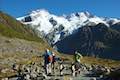
Even though the mountains are dramatic, visitors can easy drive right into Aoraki Mount Cook National Park and start exploring. Mount Cook Village provides lodging and amenities, and nearby White Horse Hill Campground is a great place to camp amidst the park’s fantastic hiking trails. For a stunning day hike that’s not too challenging, take Hooker Valley Track up to an iceberg-filled lake below Mount Cook. For something super steep and scenic, ascend the Sealy Range to Sealy Tarns and Mueller Hut – it’s an experience you will never forget. For easy outings to beautiful viewpionts, take short walks to Kea Point and Tasman Glacier View. Aoraki Mount Cook National Park in an incredible place to visit that belongs on the itinerary of any outdoor enthusiast visiting New Zealand’s South Island.

Dogs and other pets are not allowed in Mount Cook Village, the campground, or on any of the tracks in Aoraki Mount Cook National Park. Bikes are not allowed on hiking tracks, but they are permitted on vehicle roads and a few cycleways, like the bike trails bordering Hooker Valley Road and Tasman Valley Road.

Tracks in Aoraki Mount Cook National Park

Aoraki Mount Cook National Park has hikes ranging from easy to difficult that all deliver rewarding views.

Hooker Valley Track
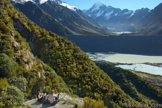
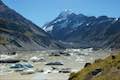
Hooker Valley Track
This superb 11-kilometer round trip hike heads up Hooker Valley to an iceberg-filled lake at the end of an impressive glacier below Mount Cook.
Kea Point TrackKea Point Track
This easier 3-kilometer round trip walk goes to landing above Mueller Lake with views of Mount Sefton and Mount Cook.
Sealy Tarns Track
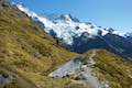
Sealy Tarns Track
This incredibly steep and incredibly scenic 5.8-kilometer round trip hike uses a string of staircases to ascend a mountainside to pools that reflect views of Mount Sefton and Mount Cook.
Mueller Hut Route
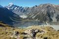
Mueller Hut Route
Ascend past Sealy Tarns on a rough route to a famed hut for a 10.5-kilometer round trip hike with spectacular views.
Mount Ollivier
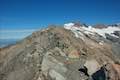
Mount Ollivier
This 1,933-meter tall summit can be reached by ascending above Mueller Hut for even grander views.
Tasman Glacier View Track
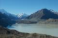
Tasman Glacier View & Blue Lakes
This pair of tracks combine for a hike of 1.85 kilometers round trip (or more) with views of small emerald pools and a large milky lake below Tasman Glacier.


Camping in Aoraki Mount Cook National Park

A campground is located close to Mount Cook Village and several hiking tracks.

White Horse Hill Campground
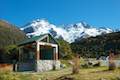
White Horse Hill Campground
This 60-site campground is surrounded by great hiking tracks and just a few kilometers from Mount Cook Village, making it an ideal place to stay during a visit to Aoraki Mount Cook National Park.


hikespeak
Devils Punchbowl Falls Arthur's Pass National Park Hike Devils Punchbowl Walking Track Arthur's Pass Village Hiking Track Devils Punchbowl Waterfall New Zealand Devil's Punchbowl
Devils Punchbowl Falls is a star attraction in Arthur's Pass National Park. The dynamic waterfall plunges 131 meters into a canyon near Arthur's Pass Village. The area's Māori named the waterfall Hinekakai, taking inspiration from its beautiful threads of water. Visitors can reach the waterfall on a 2-kilometer (1.4-mile) round trip walk beginning from Arthur's Pass Village. Devils... Read more.
By: Published: Last updated: May 6, 2017
Otira Valley Track Arthur's Pass National Park Hike Arthur's Pass Village Hiking Track New Zealand
Just over the north side of Arthur's Pass and 5 kilometers from Arthur's Pass Village, you'll find Otira Valley Track, which ascends a trough-shaped valley off the west side of the pass. The track ends at Otira River Footbridge. Under normal circumstances, a bridge would be an odd place to end a hike (since a bridge lead to something on the other side). The route beyond Otira River... Read more.
OK! Add to trails I’ve hiked
OK! Add to trails I want to hike
Tagged with · Arthur's Pass Village · Creeks · Free Trails · New Zealand Department of Conservation · New Zealand National Parks · Arthur's Pass National Park
Distance: 3.8 kilometers / 2.35 miles · Elevation change: 125 meters / 410 feet
By: Published: Last updated: May 6, 2017
Bealey Chasm Walk Arthur's Pass National Park Hike Bealey River Hiking Track Bealey Valley Track Footbridge Arthur's Pass Village New Zealand
North of Arthur's Pass Village, Bealey River passes through a narrow gorge, creating a mix of tumbling white water and blue pools. A footbridge on Bealey Valley Track crosses over this point on the river, called Bealey Chasm. Visit the chasm on a short walk beginning from State Highway 73. Bealey Chasm Walk starts with a short section of Arthur's Pass Walking Track and connects to Bealey... Read more.
OK! Add to trails I’ve hiked
OK! Add to trails I want to hike
Tagged with · Arthur's Pass Village · Creeks · Free Trails · New Zealand Department of Conservation · New Zealand National Parks · Arthur's Pass National Park
Distance: 0.65 kilometers / 0.4 miles · Elevation change: 12 meters / 40 feet
By: Published: Last updated: May 6, 2017
Old Coach Road Walk Arthur's Pass National Park Hike Greyneys Shelter Arthur's Pass Hiking Track New Zealand
This mostly unremarkable woodland walk explores the forest a few kilometers south of Arthur's Pass Village. Much of the track follows an old coach road that went to Arthur's Pass so the walk provides a history lesson on the area's earlier travelers. The easy walk is 1 to 1.4 kilometers long, starting and ending at Greynes Shelter Campground. With just 15 meters of elevation change along... Read more.
OK! Add to trails I’ve hiked
OK! Add to trails I want to hike
Tagged with · Arthur's Pass Village · Free Trails · New Zealand Department of Conservation · New Zealand National Parks · Arthur's Pass National Park
Distance: 1.4 kilometers / 0.9 miles · Elevation change: 15 meters / 50 feet
By: Published: Last updated: May 6, 2017
Millennium Walk Avalanche Creek Waterfall Arthur's Pass National Park Hike Avalanche Creek Falls Arthur's Pass Hiking Track New Zealand
Millennium Walk is a very short hike from the visitor center for Arthur's Pass National Park to a viewing platform alongside Avalanche Creek Waterfall. This walk is 500 meters round trip with only a few meters of elevation change, covered over stone steps at the end of the walk. If you stop by the visitor center in Arthur's Pass Village, this short walk to the waterfall is well worth your... Read more.
By: Published: Last updated: May 6, 2017