Joshua Tree Desert Queen Mine Hike
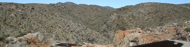
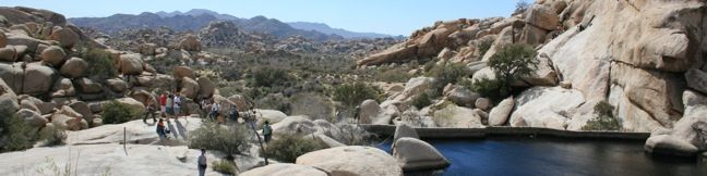
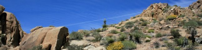
This short desert hike visits a gold mine that operated profitably for decades on land now protected by Joshua Tree National Park. An overlook across from the mine is reachable via an easy 0.7-mile round trip trail, and the excursion can be extended to 1.6 miles by crossing a canyon to the mine itself. Begin hiking on the nearly level Desert Queen Mine Trail (just to the right of the... Read more.
By: Published: Last updated: January 16, 2020
Joshua Tree Barker Dam Hike joshua Tree National Park Trail desert reservoir dam look hike
Barker Dam Loop visits a small foreign-looking reservoir within the Wonderland of Rocks in Joshua Tree National Park. Hikers of all abilities will enjoy this level 1.5-mile hike. The water can all but disappear during the dry season, so make a point to visit this trail in the winter and spring. The well-marked loop is easy to follow and easy to hike. From the parking lot, take the trail... Read more.
By: Published: Last updated: January 16, 2020
Joshua Tree Mastodon Peak Hike California National Park Trail Cottonwood Springs
Mastodon Peak offers panoramic views of southeastern Joshua Tree National Park. The low summit is located in the Colorado Desert, so you will not see any Joshua trees around here. What you will see is some beautify desert that becomes populated with wildflowers come spring. Mastodon Peak can be reached via a 2.6-mile loop with 440 feet of elevation gain. The easiest way to complete... Read more.
By: Published: Last updated: June 7, 2017
San Vicente Mountain Hike Los Angeles Mulholland Drive
The shortest route up San Vicente Mountain approaches the peak from the east. This 2-mile round trip hike follows an unpaved portion of Mulholland Drive and climbs just 335 feet. In the 1950s, San Vicente Mountain was used to defend Los Angeles from soviet missile attacks. Like Mount Disappointment in the San Gabriel Mountains and White Point on the Palos Verdes Peninsula, San Vicente... Read more.
By: Published: Last updated: December 7, 2018
Topanga Lookout Hike Malibu easy trail Topanga Tower Santa Monica Mountains
At a saddle in the Santa Monica Mountains 2,375 feet above the Pacific Ocean and 3 miles from the coast, the Backbone Trail crosses Stunt Road, creating a high trailhead for nearby destinations. Topanga Lookout, the former site of a fire tower, stands above Red Rock Canyon Park and continues to offer fine views of the Santa Monica Mountains, Calabasas, and the Santa Susana Mountains. This... Read more.
By: Published: Last updated: June 5, 2017
Saddle Peak Hike Malibu California Ocean View Trail
At a saddle in the Santa Monica Mountains 2,375 feet above the Pacific Ocean and three miles from the coast, the Backbone Trail crosses Stunt Road, creating a high trailhead for nearby destinations like Saddle Peak. The 2-mile round trip hike to the summit climbs just 450 feet but offers fantastic views of Malibu and the Santa Monica Mountains. A spring bloom of gazanias (invasive) along... Read more.
By: Published: Last updated: June 5, 2017
Hiking to the Nazi ruins of Murphy Ranch in Rustic Canyon from Sullivan Ridge Fire Road. Cement stairs, trail, hike, Topanga State Park, Will Rogers, Santa Monica Mountains, Pacific Palisades Los Angeles, graffiti buildings
In the 1930s, Nazi sympathizers built a refuge in the Pacific Palisades. Herr Schmidt, Winona and Norman Stephens, and their followers occupied a self-contained stronghold in what is now Rustic Canyon between Sullivan Ridge and Will Rodgers State Park. Murphy Ranch was designed to serve as a hold out for fans of the Third Reich waiting for America to fall to the Nazis. Instead, the ranch... Read more.
By: Published: Last updated: February 8, 2018
Sullivan Ridge Hike Sullivan Ridge Trail Santa Monica Mountains California Sullivan Ridge Fire Road
Sullivan Ridge rises between Rustic Canyon and Sullivan Canyon east of Will Rogers State Park in a region of the Santa Monica Mountains aptly named the Big Wild. A 6.3-mile long fire road runs along the ridge, accompanied by a single-track trail that diverges from the road to explore more of Sullivan Ridge. A prominent lone-standing live oak along the road makes a natural turnaround point... Read more.
By: Published: Last updated: January 17, 2018
Sullivan Canyon Trail hike Brentwood Pacific Palisades Santa Monica Mountains Los Angeles California
Sullivan Canyon runs north to south in the Santa Monica Mountains east of Will Rodgers State Park. This 8.5-mile round trip hike departs from a residential street a couple miles north of Sunset Boulevard and follows a wide trail up the center of a sycamore-filled canyon. Sullivan Canyon A green wall across Queensferry Road marks the start of the hike. Beyond the gate, the road descends... Read more.
By: Published: Last updated: January 17, 2018
Westridge Trail to San Vicente Mountain Brentwood Los Angeles hikes
In the 1950s, San Vicente Mountain served as a mountaintop military installation to defend Los Angeles from soviet missile attacks. Today, the 1,960-foot peak provides visitors with a look back at this chapter in the city's history, along with a great view of West LA and the Santa Monica Mountains. Westridge Fire Road leads to San Vicente Mountain and is a popular path for mountain bikers,... Read more.
By: Published: Last updated: December 7, 2018