Inspiration Point Trail Will Rogers State Historic Park Los Angeles Brentwood Pacific Palisades Santa Monica Bay Scenic overlook viewpoint loop hike
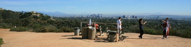
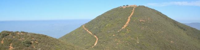
In addition to a rare polo field, renown ranch house, and a lawn that begs to be picnicked on, Will Rogers State Historic Park has plenty to offer to hikers. This is the eastern end of the 65-mile long Backbone Trail, which crosses the Santa Monica Mountains all the way to Point Mugu, and Will Rogers SHP is also home to a delightful short hike to a popular overlook. The loop to Inspiration... Read more.
By: Published: Last updated: January 17, 2018
Cerro Alto Los Padres National Forest San Luis Obispo Morro Bay Hike trail high point Cerro Alto Peak
The 2,624-foot summit of Cerro Alto is one of the highest points in San Luis Obispo County and delivers a panoramic view. It seems like you can see the entire county from the top of the commanding peak, including each of the volcanic peaks stretching between Morro Bay and Edna Valley, the Nine Sisters. There are a couple ways to the summit, each tackling 1,600 feet of elevation between the... Read more.
OK! Add to trails I’ve hiked
OK! Add to trails I want to hike
Tagged with · Los Padres National Forest · Ocean Views · Summits
Distance: 5.35 miles · Elevation change: 1600 feet
By: Published: Last updated: April 19, 2018
Cerro Cabrillo Peak Morro Bay State Park San Luis Obispo California Nine Sister hike trail Tiki Rock
Nine principle volcanic plugs are spread between the central coast cities of Morro Bay and San Luis Obispo. The 911-foot Cerro Cabrillo (or Cabrillo Peak) is the third of the Nine Sisters from the west after Morro Rock and Black Hill. The summit of Cerro Cabrillo is the highest point in Morro Bay State Park, offering panoramic oceanfront views.  The unmaintained trail to the summit passes... Read more.
OK! Add to trails I’ve hiked
OK! Add to trails I want to hike
Tagged with · California State Parks · Free Trails · Morro Bay · Morro Bay State Park · Morros · Ocean Views · Off Trail · Summits
Distance: 2.5 miles · Elevation change: 900 feet
By: Published: Last updated: June 7, 2017
Turtle Rock Chorro Trail Morro Bay State Park San Luis Obispo hike California Morro Estuary Los Osos
If you are looking for an easy 45-minute hike to the top of a pimple of a hill between two of San Luis Obispo's Nine Sisters, take Chorro Trail to Turtle Rock in Morro Bay State Park. This 2.1-mile round trip hike begins with views of the estuary feeding Morro Bay and ends atop a small rise between Black Hill and Cerro Cabrillo. There is only 200 feet of elevation gain along the way, making... Read more.
OK! Add to trails I’ve hiked
OK! Add to trails I want to hike
Tagged with · California State Parks · Free Trails · Morro Bay · Morro Bay State Park · Morteros · Ocean Views
Distance: 2.1 miles · Elevation change: 200 feet
By: Published: Last updated: May 20, 2017
Portola Point Trail Morro Bay State Park San Luis Obispo hike California Portola Hill Morro Estuary view
It can feel like stealing when you snag great views from an easy hike. This is the situation on the 2-mile loop to Portola Point in Morro Bay State Park, which ascends 315 feet to panoramic views over Morro Bay. The view-to-effort ratio on this hike is quite favorable, almost criminal. Portola Hill is a dome-shaped volcanic rise on the eastern edge of Morro Estuary. The 329-foot hill is... Read more.
OK! Add to trails I’ve hiked
OK! Add to trails I want to hike
Tagged with · California State Parks · Free Trails · Morro Bay · Morro Bay State Park · Ocean Views · Summits
Distance: 2 miles · Elevation change: 315 feet
By: Published: Last updated: May 20, 2017
Eagle Rock Nature Trail Loop El Chorro regional Park hike San Luis Obispo Morro Bay Highway One
Along Highway One between San Luis Obispo and Morro Bay, is a regional park with over 700 acres of land that were formerly part of Camp San Luis. The versatile El Chorro Regional Park sports a 63-site campground, a botanical garden, playground, picnic area, dog park, volleyball courts, ball fields, and Dairy Creek Golf Course. Additionally, the park hosts a 2.4-mile loop to Eagle Rock... Read more.
OK! Add to trails I’ve hiked
OK! Add to trails I want to hike
Tagged with · El Chorro Regional Park · Free Trails · Morteros · Nature Trails
Distance: 2.4 miles · Elevation change: 450 feet
By: Published: Last updated: May 20, 2017
Sydney Street Trail Murray Hill San Luis Obispo Hike
If the hike at your own risk sign at the start of Sydney Trail doesn't intimidate you, maybe the 1,275-foot climb over 1.4 miles (one-way) will. This is a steep hike up a rocky road. The destination is a stone seating area at the top of Murray Hill (also known as Unnamed Hill), a 1,715-foot summit in the Santa Lucia Foothills with panoramic views over San Luis Obispo, more commonly reached... Read more.
OK! Add to trails I’ve hiked
OK! Add to trails I want to hike
Tagged with · Free Trails · Summits
Distance: 2.8 miles · Elevation change: 1275 feet
By: Published: Last updated: February 12, 2019
Islay Hill Trail San Luis Obispo Islay Hill Open Space hike Morros Nine Sisters SLO
Islay Hill stands at the eastern end of the chain of volcanic plugs running across San Luis Obispo. If Bishop Peak is the most iconic Morro, than Islay Hill is about the easiest to hike (with the exception of Black Hill). The dome-shaped 776-foot summit is more mound than mountain, but you will find 550 feet of elevation gain on the 1.8-mile round trip hike to the top. Since Islay Hill is... Read more.
OK! Add to trails I’ve hiked
OK! Add to trails I want to hike
Tagged with · Free Trails · Morros
Distance: 1.8 miles · Elevation change: 550 feet
By: Published: Last updated: April 2, 2019
Beacon Hill Trail hike Griffith Park Los Angeles California Hollywood
Located in the southeast corner of Griffith Park, Beacon Hill is the easternmost summit in the Santa Monica Mountain Range. The 1,001-foot hill towers over the Los Angeles River and provides panoramic views from Burbank to Santa Monica Bay. On a clear day, Beacon Hill issues a stunning panorama. The summit can be reached via a 2.75-mile out and back hike, or a 3.9-mile loop, both with 500... Read more.
OK! Remove from my hikes
OK! Add to trails I want to hike
Tagged with · Free Trails · Summits · Dog-Friendly Trails · Griffith Park · Santa Monica Mountains
Distance: 3.9 miles · Elevation change: 500 feet
By: Published: Last updated: December 7, 2018
Crystal Lake Trail Los Angeles San Gabriel Mountains Angeles National Forest Azusa California hike San Gabriel Mountains National Monument
Diminished by drought and tarnished by wildfire, Crystal Lake is not the glistening destination it once was. Crystal Lake is the only naturally occurring lake in the San Gabriel Mountains, cradled by granite summits north of the San Gabriel River Valley above the city of Azusa at 5,500 feet. It is a 1 1/3-mile round trip paved hike to Crystal Lake with 150 feet of elevation gain. The 2002... Read more.
By: Published: Last updated: January 8, 2019