Glendale Peak – Mount Hollywood Loop in Griffith Park
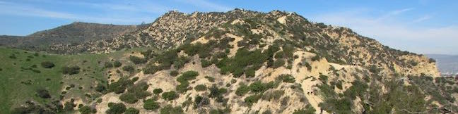
It is often said that two is better than one. Take a hike on Glendale Peak – Mount Hollywood Loop and you'll agree – two summits are better than one! Think of this Griffith Park hike like a meal with an appetizer and a main course. Glendale Peak is the appetizer, rising to 1,190 feet with tastier-than-expected views over southeast end of the park toward downtown Los Angeles and the San Gabriel Mountains. ...Read more.
Distance: 4.15 miles · Elevation change: 765 feet
By: Published: May 3, 2016 Last updated: December 5, 2025
Pilot Butte in Bend
Pilot Butte is the biggest landmark in the city of Bend. This extinct cinder volcano is visible from almost everywhere in the city and its summit surpasses expectations with knock-out views of over Bend toward high desert landscapes and snowcapped Cascade Mountains. An extraordinary collection of mountains that includes Mount Hood, Mount Jefferson, Three Fingered Jack, the Three Sisters and Mount Bachelor are visible on clear days. ...Read more.
Distance: 1.8 miles · Elevation change: 475 feet
By: Published: April 29, 2016 Last updated: December 6, 2025
Head of the Metolius in Deschutes National Forest
Gaze north from the observation site at the end of Head of the Metolius Trail and you'll have a beautiful (if traditional) view of a river flowing through a pine forest toward Mount Jefferson. Look in the other direction to see something unexpected. The river springs to live all at once from a surprising, gushing source. The trail to Head of the Metolius in Deschutes National Forest is a quarter mile long and paved. ...Read more.
Distance: 0.5 miles · Elevation change: 35 feet
By: Published: April 27, 2016 Last updated: April 16, 2026
Calico I & Calico II in the Calico Hills in Red Rock Canyon National Conservation Area
The whimsically concocted concentration of vibrant red-orange Aztec sandstone known as the Calico Hills is a must-see destination in Red Rock Canyon National Conservation Area. After leaving the visitor center, the Scenic Drive heads straight to the Calico Hills, passing three overlooks and trailheads, Calico I, Calico II, and Sandstone Quarry (the start of Calico Tanks Trail). ...Read more.
Distance: 2.1 miles · Elevation change: 200 feet
By: Published: April 26, 2016 Last updated: December 5, 2025
Willow Springs Loop in Red Rock Canyon National Conservation Area
Willow Springs Loop explores an area off the northwest side of the Scenic Drive through Red Rock Canyon National Conservation Area. While it is bordered by steep mountains, the loop actually crosses easy terrain along Red Rock Wash. Visit pictographs left behind by Native American's near Willow Springs Picnic Area and meander through desert landscapes. ...Read more.
Distance: 1.33 miles · Elevation change: 165 feet
By: Published: April 22, 2016 Last updated: April 8, 2026
Lost Creek Canyon in Red Rock Canyon National Conservation Area
This short hike ventures into a canyon to Lost Creek Waterfall, a seasonal desert falls. Cross through a riparian area below tall cliffs in the Spring Mountains of Red Rock Canyon National Conservation Area. Lost Creek Canyon Trail is 0.35 miles long and can be done as a 0.7-mile out and back hike with 165 feet of elevation change. Form a circuit with Lost Creek Children's Discovery Loop Trail to explore surrounding rock formations (including a pictograph) on a 0. ...Read more.
Distance: 0.7 miles · Elevation change: 165 feet
By: Published: April 22, 2016 Last updated: December 5, 2025
Calico Tanks in Red Rock Canyon National Conservation Area
Calico Tanks Trail is one of the most popular hikes in Red Rock Canyon National Conservation Area, and for good reason. The trail ventures up a canyon colored in both yellow and red sandstone. Add the gray-blue mountains to the northwest and you get some seriously vibrant views. The trail ends with two rewards, a hopefully-not-dry pond and an overlook of Las Vegas. ...Read more.
Distance: 2.5 miles · Elevation change: 420 feet
By: Published: April 18, 2016 Last updated: December 5, 2025
Red Spring Boardwalk in Red Rock Canyon National Conservation Area
How significant is water in the desert? Head to Read Spring to find out, where a 0.55-mile boardwalk circles an out-of-place meadow fed by a small spring. Red Spring spills from the base of the Calico Hills beneath a ridge of wildly shaped sandstone. While most of the trails in Red Rock Canyon NCA begin along the Scenic Drive, Red Spring Boardwalk sets out from a picnic area off Calico Basin Road on the east side of the park closest to Las Vegas. ...Read more.
Distance: 0.55 miles · Elevation change: 50 feet
By: Published: April 14, 2016 Last updated: December 5, 2025
Lower Macleay Trail to Stone House (Witch’s Castle) in Forest Park, Portland
Do you like to hike but suffer from a little bit of fomo (fear of missing out)? Make your way to Northwest Portland for an outing in Forest Park that has a bit of everything. Start up Lower Macleay Trail along Balch Creek, the park's biggest year-round stream. Hike less than a mile through a verdant rainforest to arrive at Stone House (imaginatively nicknamed the Witch's Castle), where the ruins of an old building are alluringly grown over with moss and ferns. ...Read more.
Distance: 2 miles · Elevation change: 400 feet
By: Published: April 12, 2016 Last updated: April 9, 2026
Lower Macleay Park to Pittock Mansion in Forest Park, Portland
Hike a couple miles through the temperate rainforest in Forest Park and you could easily forget how close you are to downtown Portland. Jog your memory by hiking up to Pittock Mansion for a major view over the city. This 5.4-mile hike with 850 feet of elevation change starts from Lower Macleay Park in Northwest Portland. Stroll along Balch Creek on Lower Macleay Trail to Stone House and examine captivating ruins that make a fine destination on their own. ...Read more.
Distance: 5.4 miles · Elevation change: 850 feet
By: Published: April 12, 2016 Last updated: April 10, 2026