Mosier Twin Tunnels via Historic Columbia River Highway State Trail in Columbia River Gorge
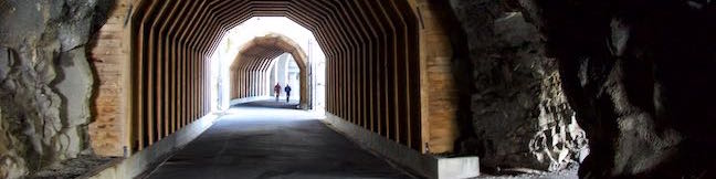
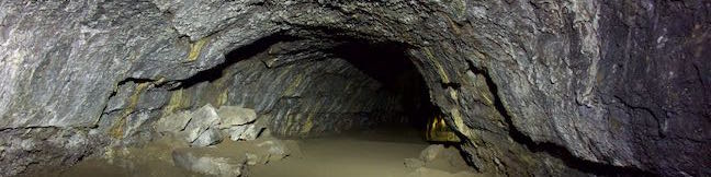
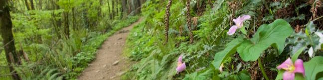
With its grand river and towering cliffs, the Columbia River Gorge is a tough place to build a roadway. See one of the engineering feats used to build a road through the gorge by moseying over to the Mosier Twin Tunnels. This picturesque pair of tunnels can be crossed on Historic Columbia River Highway State Trail, which follows the route of the century old road that crossed the gorge long before I-84. ...Read more.
Distance: 4.8 miles · Elevation change: 320 feet
By: Published: June 20, 2016 Last updated: December 5, 2025
Ecola Point to Indian Beach in Ecola State Park
The Oregon coast is a rugged and wild with evergreen topped sea cliffs. Jagged shorelines hide tucked away beaches and dramatic rocks islands. One great place to witness this beautiful scenery is Ecola State Park, preserving 1,024-acres on Tillamook Head, which is just north of Cannon Beach and about 80 miles northwest of Portland. An 8-mile section of Oregon Coast Trail cuts through the park, including a 1 1/3-mile stretch connecting the park's two main drive-up destinations, Ecola Point and Indian Beach. ...Read more.
Distance: 2.65 miles · Elevation change: 350 feet
By: Published: June 6, 2016 Last updated: December 6, 2025
Cape Meares Lighthouse & Octopus Tree in Cape Meares State Park
A two-for-one special is going on at Cape Meares State Park. Here's the deal – two short hikes for the price of one (which is free). Take one trail to a well preserved more-than-a-century-old lighthouse on the Oregon coast, followed immediately by another short trail to a sprawling spruce worthy of its name, the Octopus Tree. Combine Cape Meares Lighthouse Trail and Octopus Tree Trail for hike that's less than a mile round trip with 180 feet of elevation change and oodles of ocean views. ...Read more.
Distance: 0.8 miles · Elevation change: 180 feet
By: Published: June 2, 2016 Last updated: December 9, 2025
Cape Kiwanda in Cape Kiwanda Natural Area
Cape Kiwanda is the southernmost of the 3 Capes in the Tillamook area on the Oregon Coast. An Oregon State Parks Natural Area protects this short, dramatic point. The park is too small to have a visitor center or hiking trails, but is a scenic spot for a walk in the sand. This short trek is 1-mile round trip (or more), beginning from a large beach on the south side of Cape Kiwanda. ...Read more.
Distance: 1 mile · Elevation change: 75 feet
By: Published: May 25, 2016 Last updated: December 5, 2025
Lava River Cave in Newberry National Volcanic Monument
Lava River Cave is the longest lava tube in Oregon and is fascinating to explore. Put fresh batteries in your flashlights and head to Newberry National Volcanic Monument, which is in Deschutes National Forest just a dozen miles south of Bend. Walking through Lava River Cave, you will see wild features left behind by volcanic eruptions 100,000 years ago. ...Read more.
Distance: 2.2 miles · Elevation change: 150 feet
By: Published: May 18, 2016 Last updated: December 17, 2025
Cape Lookout Trail in Cape Lookout State Park
Treat yourself to gargantuan ocean views from the edges of Cape Lookout, hiking 5 miles round trip to a viewpoint at the end of this tall promontory on the Oregon Coast. Cape Lookout Trail passes through a temperate rainforest packed with tall cedars. The forest is wild and beautiful and so is the surrounding coastline. Cape Lookout is probably the most impressive cape on Three Capes Scenic Route and this out and back hike serves up great views. ...Read more.
Distance: 5 miles · Elevation change: 440 feet
By: Published: May 17, 2016 Last updated: December 5, 2025
Marquam Trail Loop in Marquam Nature Park, Portland
Marquam Nature Park is walking distance from downtown Portland, but is tucked away and remains less well known than other parks in the West Hills. Marquam Nature Park provides ample woodland solitude, despite its proximity to downtown. To explore most of this underused parcel of the West Hills near OHSU, create a a 4.25-mile loop with 500 feet of elevation change that combines multiple trails: Shelter Loop Trail Marquam Trail Flicker Trail Towhee Trail Upper Marquam Hill Trail The loop is oddly shaped and nearly connects at two points along the way, allowing the hike to be shortened to 1. ...Read more.
Distance: 4.25 miles · Elevation change: 500 feet
By: Published: May 12, 2016 Last updated: December 12, 2025
Shevlin Loop Trail in Shevlin Park, Bend
Shevlin Loop Trail explores pine forests along Tumalo Creek in Shevlin Park, which is just four miles west of downtown Bend. This pleasant woodland trail is mostly easy with a few rolling sections along the bluffs that border the creek. The loop is 4.75 miles long and explores much of Shevlin Park's 647 acres. The hike has 240 feet of elevation change and crosses lovely Tumalo Creek at two points. ...Read more.
Distance: 4.75 miles · Elevation change: 240 feet
By: Published: May 8, 2016 Last updated: December 5, 2025
Archie Briggs Canyon Trail in Bend
Archie Briggs Natural Area presents views over a dramatic stretch of the Deschutes River north of Bend. The river makes a sweeping curve beneath tall cliffs of volcanic rock and is backed by grand mountains like Black Butte and Mount Jefferson. Gaze down the canyon from atop cliffs on the south side of the curve in the river by an intersection of Deschutes River Trail and Archie Briggs Canyon Trail. ...Read more.
Distance: 1.25 miles · Elevation change: 325 feet
By: Published: May 5, 2016 Last updated: December 6, 2025
Glendale Peak in Griffith Park
Mount Hollywood and Mount Lee might get the bulk of the summit-bagging hikers in Griffith Park, but Glendale Peak is a fine target of its own, hosting grand views of downtown Los Angeles, the San Gabriel Valley, and the San Gabriel Mountains. The 1,190-foot peak pokes out above the southeast side of Griffith Park at the end of a ridge that runs down from Mount Hollywood. ...Read more.
Distance: 3.3 miles · Elevation change: 405 feet
By: Published: May 3, 2016 Last updated: April 8, 2026