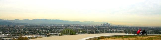
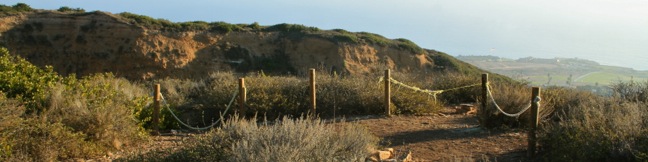
Bronson Cave Trail hike Griffith Park Los Angeles California bat cave hiking Hollywood Bronson Caves
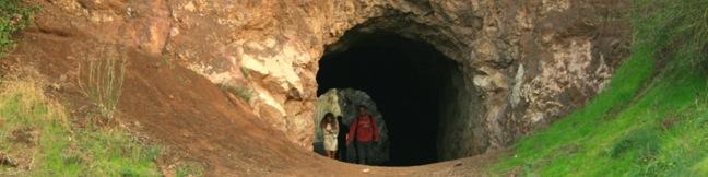
Bronson Cave is one of Hollywood's favorite filming locations. The man-made tunnel is carved into the rock wall of an old quarry in Griffith Park. Bronson Cave‘s most famous role came in the 1960s, playing the entrance of the Batcave in the Batman TV series. The cave continues to be cast in television shows and movies. Thanks to a very short trail, it is about as easy to see Bronson Cave in real life as it is on screen. ...Read more.
My Hikes: Completed hikeA green icon of shows a picture of a landscape with a check mark in the upper right corner, signifying that this is a hike you would like to put on your completed list.OK! Add to trails I've hiked
My Hikes: Want to hikeA green icon of shows a picture of a landscape with a heart in the upper right corner, signifying that this is a hike you would like to put on your to-do list.OK! Add to trails I want to hike
TagsA green icon depicting a tags represents a list of words and phrases that this content is tagged with Tagged with · Caves · Free Trails · Hollywood · Dog-Friendly Trails · Griffith Park · Santa Monica Mountains
Hike DistanceA green icon of a hiker used to label information about the length of the hike Distance: 0.65 miles · Elevation change: 50 feet
By: Published: Last updated: May 13, 2025
Baldwin Hills Scenic Overlook Trail Culver City hike Los Angeles California scenic viewpoint state park steps staircase hike LA vista, exercise, workout, stairs
Baldwin Hills Scenic Overlook provides a grand view over LA from a steep hill south of Culver City. The unique perspective looks north over the Los Angeles Basin that extends from Santa Monica Bay to the west, across the Hollywood Hills toward downtown Los Angeles and the San Gabriel Mountains to the east. At Baldwin Hills Scenic Overlook State Park you don't choose between taking the elevator and taking the stairs. ...Read more.
My Hikes: Completed hikeA green icon of shows a picture of a landscape with a check mark in the upper right corner, signifying that this is a hike you would like to put on your completed list.OK! Add to trails I've hiked
My Hikes: Want to hikeA green icon of shows a picture of a landscape with a heart in the upper right corner, signifying that this is a hike you would like to put on your to-do list.OK! Add to trails I want to hike
TagsA green icon depicting a tags represents a list of words and phrases that this content is tagged with Tagged with · Baldwin Hills Scenic Overlook State Park · California State Parks · Culver City · Free Trails · Stairs · Summits
Hike DistanceA green icon of a hiker used to label information about the length of the hike Distance: 2.5 miles · Elevation change: 315 feet
By: Published: Last updated: May 21, 2017
Quarry Loop hike Pirate Trail Mariposa Loop Forrestal Reserve hiking Palos Verdes Peninsula Los Angeles
On the southwest side of the Palos Verdes Peninsula, Forrestal Nature Reserve protects 155-acres of green space on the cliffs above the Pacific. Within the park, Quarry Loop circles an old basalt quarry and provides tons of ocean views. The hike combines four trails (Quarry Trail, Basalt Trail, Mariposa Trail, and Pirate Trail) on a short 1.25-mile loop. ...Read more.
My Hikes: Completed hikeA green icon of shows a picture of a landscape with a check mark in the upper right corner, signifying that this is a hike you would like to put on your completed list.OK! Add to trails I've hiked
My Hikes: Want to hikeA green icon of shows a picture of a landscape with a heart in the upper right corner, signifying that this is a hike you would like to put on your to-do list.OK! Add to trails I want to hike
TagsA green icon depicting a tags represents a list of words and phrases that this content is tagged with Tagged with · Free Trails · Ocean Views · Rancho Palos Verdes · Dog-Friendly Trails · Palos Verdes Peninsula
Hike DistanceA green icon of a hiker used to label information about the length of the hike Distance: 1.25 miles · Elevation change: 325 feet
By: Published: Last updated: May 21, 2017
Upper Winter Creek Trail Santa Anita Canyon Hoegees Camp Loop hike Chantry Flats San Gabriel Mountains Los Angeles National Forest Arcadia Mount Wilson Mt. Wilson
If you have hiked Santa Anita Canyon Loop, you probably wondered, were can I find more great trails like this? The answer is Upper Winter Creek Trail, a 2.75-mile track on the east wall of Santa Anita Canyon with 600 feet of elevation change. Upper Winter Creek Trail can be used to replace Lower Winter Creek Trail on Santa Anita Canyon Loop to create a slightly larger ten-mile loop that trades in creek crossings for canyon views. ...Read more.
My Hikes: Completed hikeA green icon of shows a picture of a landscape with a check mark in the upper right corner, signifying that this is a hike you would like to put on your completed list.OK! Add to trails I've hiked
My Hikes: Want to hikeA green icon of shows a picture of a landscape with a heart in the upper right corner, signifying that this is a hike you would like to put on your to-do list.OK! Add to trails I want to hike
TagsA green icon depicting a tags represents a list of words and phrases that this content is tagged with Tagged with · Adventure Pass · Angeles National Forest · Arcadia · Creeks · Dog-Friendly Trails · Mountain Biking Trails · San Gabriel Mountains
Hike DistanceA green icon of a hiker used to label information about the length of the hike Distance: 4.85 miles · Elevation change: 1000 feet
By: Published: Last updated: May 13, 2025
Los Angeles Camping developed campgrounds trail camps southern california
Despite being one of the biggest metropolitan areas in the world, Los Angeles is surrounded by great camping. Below is a list of some, but certainly not all, of the campgrounds around LA. For additional information about camping in the area's biggest mountain ranges visit: The official camping webpage of the Santa Monica Mountains The official camping webpage of the Angeles National Forest If you have a specific spot in mind, you can also search for campgrounds by location on hikespeak's campgrounds map. ...Read more.
TagsA green icon depicting a tags represents a list of words and phrases that this content is tagged with Tagged with · Tent Camping · San Gabriel Mountains · Santa Monica Mountains
By: Published: Last updated: July 1, 2025
Bridge to Nowhere hike Los Angeles San Gabriel Mountains Angeles National Forest California trail
For outdoor-loving Angelinos, Bridge to Nowhere is the affectionate name of a local treasure, an abandoned bridge on a washed-away road in the San Gabriel Mountains that spans across the East Fork of the San Gabriel River. You'll find excessive fun on this 10-mile round trip hike with 900 feet of elevation change. The trail uses several river fords to reach the Bridge to Nowhere, adding opportunities to stop and swim. ...Read more.
My Hikes: Completed hikeA green icon of shows a picture of a landscape with a check mark in the upper right corner, signifying that this is a hike you would like to put on your completed list.OK! Add to trails I've hiked
My Hikes: Want to hikeA green icon of shows a picture of a landscape with a heart in the upper right corner, signifying that this is a hike you would like to put on your to-do list.OK! Add to trails I want to hike
TagsA green icon depicting a tags represents a list of words and phrases that this content is tagged with Tagged with · Adventure Pass · Angeles National Forest · Azusa · Creeks · San Gabriel Mountains National Monument · Sheep Mountain Wilderness · Dog-Friendly Trails · San Gabriel Mountains
Hike DistanceA green icon of a hiker used to label information about the length of the hike Distance: 10 miles · Elevation change: 900 feet
By: Published: Last updated: May 13, 2025
Angeles National Forest reopens
For the last year and a half, an immense area of the San Gabriel Mountains has been off limits. Now it's back! Incredible news from the US Forest Service who announced: Effective May 16, [2011] the Angeles National Forest will reopen about half of the areas that have been closed due to the Station Fire. Hikers have battled stunning crowds in pockets of the forest that remained open, like Santa Anita Canyon. ...Read more.
TagsA green icon depicting a tags represents a list of words and phrases that this content is tagged with Tagged with · Adventure Pass · Angeles National Forest · San Gabriel Mountains
By: Published: Last updated: December 9, 2016
Echo Mountain Sam Merrill Trail White City Resort Mount Lowe Railway hike San Gabriel Mountains Angeles National Forest Pasadena Altadena
Long ago, back in the 90s - that is the 1890s, the resort built on Echo Mountain was one of the largest tourist draws in California. Thaddeus Lowe's resort, known as the White City, was perched at an elevation of 3,200 feet, overlooking the city of Pasadena and a grand stretch of Southern California. The resort was long ago destroyed by wildfires, leaving fascinating ruins for present day visitors to explore. ...Read more.
My Hikes: Completed hikeA green icon of shows a picture of a landscape with a check mark in the upper right corner, signifying that this is a hike you would like to put on your completed list.OK! Add to trails I've hiked
My Hikes: Want to hikeA green icon of shows a picture of a landscape with a heart in the upper right corner, signifying that this is a hike you would like to put on your to-do list.OK! Add to trails I want to hike
TagsA green icon depicting a tags represents a list of words and phrases that this content is tagged with Tagged with · Altadena · Angeles National Forest · Free Trails · Pasadena · Ruins · Dog-Friendly Trails · Mountain Biking Trails · San Gabriel Mountains
Hike DistanceA green icon of a hiker used to label information about the length of the hike Distance: 5.8 miles · Elevation change: 1400 feet
By: Published: Last updated: May 13, 2025
Rubio Canyon Waterfalls hike San Gabriel Mountains Angeles National Forest Pasadena trail Ribbon Rock Falls Moss Grotto Falls Altadena
This short hike travels up a narrow history-filled canyon to a charming double waterfall.  At the turn of the previous century, the canyon was home to Rubio Pavilion, at the base of the Mount Lowe Incline Tramway, which escorted visitors to an immensely popular resort atop the ridge to the west.  A hundred years later, only the foundation remains and nature has rebounded to provide a rustic hiking alley. ...Read more.
My Hikes: Completed hikeA green icon of shows a picture of a landscape with a check mark in the upper right corner, signifying that this is a hike you would like to put on your completed list.OK! Add to trails I've hiked
My Hikes: Want to hikeA green icon of shows a picture of a landscape with a heart in the upper right corner, signifying that this is a hike you would like to put on your to-do list.OK! Add to trails I want to hike
TagsA green icon depicting a tags represents a list of words and phrases that this content is tagged with Tagged with · Altadena · Angeles National Forest · Free Trails · Pasadena · Waterfalls · Dog-Friendly Trails · Los Angeles Waterfalls · San Gabriel Mountains
Hike DistanceA green icon of a hiker used to label information about the length of the hike Distance: 1.3 miles · Elevation change: 350 feet
By: Published: Last updated: June 11, 2019
Lunado Canyon Trail Palos Verdes Peninsula
Lunada Canyon is a strip of open space between residential ridges on the Palos Verdes Peninsula. The 0.95-mile trail is accessible from the top and bottom of the canyon, and from another road meeting the trail 0.2 miles from the top. The upper half of Lunada Canyon Trail is overgrown, and the wall of nearby houses make it a less desirable area to hike. ...Read more.
My Hikes: Completed hikeA green icon of shows a picture of a landscape with a check mark in the upper right corner, signifying that this is a hike you would like to put on your completed list.OK! Add to trails I've hiked
My Hikes: Want to hikeA green icon of shows a picture of a landscape with a heart in the upper right corner, signifying that this is a hike you would like to put on your to-do list.OK! Add to trails I want to hike
TagsA green icon depicting a tags represents a list of words and phrases that this content is tagged with Tagged with · Free Trails · Palos Verdes Estates · Dog-Friendly Trails · Mountain Biking Trails · Palos Verdes Peninsula
Hike DistanceA green icon of a hiker used to label information about the length of the hike Distance: 1.9 miles · Elevation change: 550 feet
By: Published: Last updated: May 25, 2017