Piedras Blancas Elephant Seal Rookery trail to Piedras Blancas Light Station hike Point Piedras Blancas Lighthouse San Simeon California Northern Elephant Seal Colony Big Sur
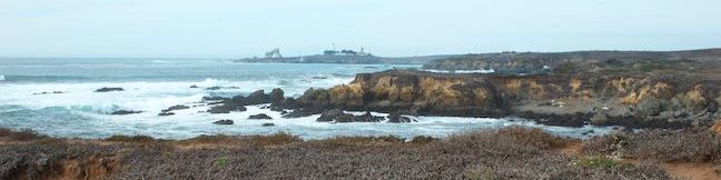
Very few places in nature would you feel comfortable getting up close to 5,000-pound animals. Piedras Blancas Elephant Seal Rookery is one of them. While visiting the seal colony, you can get up close to these impressive (and vocal) animals and observe them in their natural habitat. In addition to two quarter-mile long boardwalk trails, the rookery is also the starting point for a dirt... Read more.
By: Published: Last updated: September 10, 2019
Point San Luis Lighthouse hike Pecho Coast Trail Avila Beach San Luis Obispo California
If you're looking for a hike to a historic site on California's Central Coast with abundant ocean views, check out the 3.6-mile round trip hike on Pecho Coast Trail to the Point San Luis Lighthouse. The hike near Avila Beach crosses land owned by PG&E that is accessible only with a trail guide on organized treks. On the way to the lighthouse, you'll enjoy sweeping views over Avila Beach... Read more.
OK! Add to trails I’ve hiked
OK! Add to trails I want to hike
Tagged with · Avila Beach · California Coastal Trail · Docent-led Hikes · Lighthouses · Ocean Views
Distance: 3.5 miles · Elevation change: 300 feet
By: Published: Last updated: January 16, 2018
Oats Peak Trail Montaña de Oro State Park summit hike New Oats Peak Trail San Luis Obispo California
Oats Peak is the second highest summit in Montaña de Oro State Park, a full 26 feet taller than Valencia Peak, which is probably the park's favorite summit for hikers. Oats Peak is located a couple miles inland of Valencia Peak, sporting smaller ocean views and greater views over the Irish Hills, the canyons and ridges making up the interior of the Montaña de Oro State Park. A pair of... Read more.
OK! Add to trails I’ve hiked
OK! Add to trails I want to hike
Tagged with · California State Parks · Free Trails · Irish Hills · Los Osos · Summits · Montaña de Oro State Park
Distance: 10.8 miles · Elevation change: 1325 feet
By: Published: Last updated: August 27, 2019
Reservoir Flats Trail Montaña de Oro State Park Islay Creek Canyon Islay Creek Campground hike
Montaña de Oro State Park has every type of hike you could want, ranging from easy oceanfront strolls to difficult summit ascents. If you're feeling like Goldilocks and want something in the middle (just right), check out Reservoir Flats Trail, a 2-mile loop with 200 feet of elevation gain that is conveniently located just behind the park visitor center. The trail travels around the bottom... Read more.
By: Published: Last updated: May 11, 2017
Islay Creek Campground Montaña de Oro State Park Camping Los Osos Camp San Luis Obispo California
Montaña de Oro State Park preserves a stunning stretch of the California's Central Coast where the Irish hills meet the Pacific Ocean. Picturesque bluffs and sandy coves dominate the coastline. The inland side of the park has charming peaks and canyons. Within the park's largest canyon, Islay Creek Canyon, you'll find Islay Creek Campground. The conveniently-located campground is just... Read more.
By: Published: Last updated: March 19, 2021
Stenner Creek Canyon to The Eucs in San Luis Obispo Cal Poly hike bike trail
Crafty mountain bikers have built a playground for themselves in a eucalyptus grove in the foothills of the Santa Lucia Mountains near Cal Poly. It is 1.85 miles from a trailhead on Stenner Creek Road to The Eucs, where bikers can zip down freeride trails with impressive banked turns and jumps. Hikers can enjoy the trail up Stenner Creek Canyon too, taking in views of nearby Bishop Peak and... Read more.
OK! Add to trails I’ve hiked
OK! Add to trails I want to hike
Tagged with · Creeks · Free Trails · Freeride Trails · Santa Lucia Mountains · Waterfalls
Distance: 3.7 miles · Elevation change: 650 feet
By: Published: Last updated: January 10, 2018
Felsman Loop Trail San Luis Obispo Hike Bishop Peak Natural Reserve Felsman Trail SLO
Bishop Peak rises high over San Luis Obispo and there is nothing it overshadows more than Felsman Loop Trail. This 2.7-mile loop in Bishop Peak Natural Reserve crosses oak, sagebrush, and grass-covered slopes around the base of Bishop Peak, providing excellent views of that notable rocky summit and its San Luis Obispo surroundings. Felsman Loop Trail can be combined with Bishop Peak Trail... Read more.
OK! Add to trails I’ve hiked
OK! Add to trails I want to hike
Tagged with · Bishop Peak Natural Reserve · Free Trails
Distance: 2.7 miles · Elevation change: 525 feet
By: Published: Last updated: April 2, 2019
Harmony Headlands State Park hike Headlands Trail Cayucos Cambria California central coast easy ocean view hike
Harmony Headlands State Park preserves 784 acres along California's Central Coast between Cayucos and Cambria. Setting out from Highway One, a gradual 4.5-mile lollipop loop through the park crosses a coastal valley to reach picturesque ocean bluffs. The easy bench-lined hike ascends about 85 feet up a wide dirt road before descending 135 feet to the coast where a footpath can be used to... Read more.
OK! Add to trails I’ve hiked
OK! Add to trails I want to hike
Tagged with · California State Parks · Cambria · Cayucos · Harmony Headlands State Park · Ocean Views
Distance: 4.5 miles · Elevation change: 135 feet
By: Published: Last updated: January 9, 2018
Johnson Ranch Open Space to Irish Hills Natural Reserve Connector Trail hike Froom Canyon San Luis Obispo California Froom Ranch to Johnson Ranch Connector
If one park is good, than two parks are better, and a trail between those parks brings out the best of both. Opened in the spring of 2013, the Connector Trail between Johnson Ranch Open Space and the Irish Hills Natural Reserve links two of San Luis Obispo County's great parks. The new trail also connects hikers with grassy slopes and oak-covered ridges with views across San Luis Obispo and... Read more.
OK! Add to trails I’ve hiked
OK! Add to trails I want to hike
Tagged with · Free Trails · Irish Hills
Distance: 5 miles · Elevation change: 575 feet
By: Published: Last updated: September 10, 2019
Black Hill Trail Morro Bay State Park San Luis Obispo hike California Morros Nine Sisters Black Mountain
Of all the Morros in San Luis Obispo County, Black Hill is the easiest to summit (even easier than Islay Hill. This 661-foot volcanic peak in Morro Bay State Park can be reached by hiking 0.6 miles round trip up a dirt single track with 190 feet of elevation gain and views over the city of Morro Bay. For those looking for more, there are longer hikes to the summit starting farther down Black... Read more.
OK! Add to trails I’ve hiked
OK! Add to trails I want to hike
Tagged with · California State Parks · Free Trails · Morro Bay · Morro Bay State Park · Morros · Ocean Views · Summits
Distance: 0.6 miles · Elevation change: 190 feet
By: Published: Last updated: April 14, 2017