Chumash Painted Cave State Historic Park Santa Barbara California Los Padres National Forest Painted Cave Road
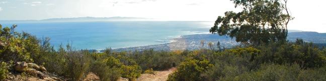
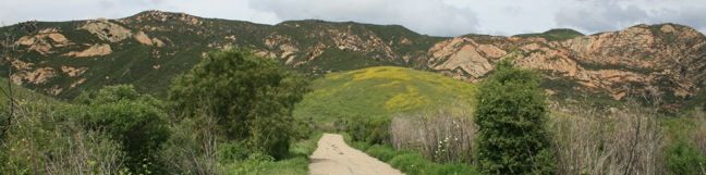
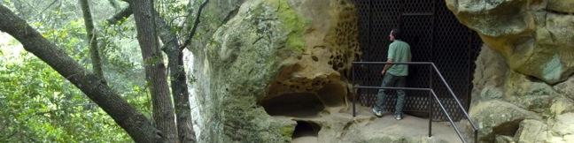
Chumash Painted Cave State Historic Park preserves centuries old Native American artwork that graces the wall of a sandstone cave in the Santa Ynez Mountains behind Santa Barbara. Chumash Painted Cave can be reached by walking a couple hundred feet up a trail on Painted Cave Road. The trailhead is just two miles from California Route 154, making it a quick, convenient, and interesting stop... Read more.
OK! Add to trails I’ve hiked
OK! Add to trails I want to hike
Tagged with · California State Parks · Caves · Free Trails · Santa Ynez Mountains
Distance: 0.1 miles · Elevation change: 20 feet
By: Published: Last updated: January 7, 2019
Montecito Peak hike Cold Springs Trail Santa Barbara California Montecito Mountain Summit Cold Spring
The Santa Ynez Mountains form a verdant backdrop behind Santa Barbara. One of the highest summits in the range is Montecito Peak, which offers sensational views over the coastal cities below and the Pacific Ocean beyond. The 3,214-foot peak can be reached via a demanding 7.1-mile round trip hike with 2,450 feet of elevation change. It is quite a trek, but the ever-expanding ocean views will... Read more.
OK! Add to trails I’ve hiked
OK! Add to trails I want to hike
Tagged with · Creeks · Free Trails · Los Padres National Forest · Montecito · Ocean Views · Santa Ynez Mountains · Summits
Distance: 7.1 miles · Elevation change: 2450 feet
By: Published: Last updated: April 26, 2017
Gaviota State Park Tunnel View Trail Trespass Trail Loop Santa Barbara hike California Highway 101
On Tunnel View Trail, you can expect to see exactly what the name advertises, a view of the Gaviota Tunnel crossed by northbound traffic on Highway 101 between Santa Barbara and Buellton. You can also expect this 2.6 mile loop with 600 feet of elevation gain to deliver a rustic hiking experience up a narrow overgrown trail. If you could tune out the din of the freeway below, the trail would... Read more.
OK! Add to trails I’ve hiked
OK! Add to trails I want to hike
Tagged with · California State Parks · Gaviota State Park · Goleta · Santa Ynez Mountains
Distance: 2.6 miles · Elevation change: 600 feet
By: Published: Last updated: May 20, 2017
Knapps Castle Trail Santa Barbara ruins Camino Cielo hike
In the mountains above Santa Barbara, a plot of privately owned land surrounded by the Los Padres National Forest. On that land stand the remains of a palatial estate that burned down seventy years ago, the so-called Knapp's Castle. To the ruins and back is a 0.8-mile round trip hike with 50 feet of elevation change. The majestic views from this unique spot far exceed the effort. From... Read more.
OK! Add to trails I’ve hiked
OK! Add to trails I want to hike
Tagged with · Los Padres National Forest · Ruins · Santa Ynez Mountains
Distance: 0.8 miles · Elevation change: 50 feet
By: Published: Last updated: January 17, 2018
Gaviota Hot Springs Trail Los Padres Santa Barbara hike Gaviota State Park spring
Driving up Highway 101 through the Gaviota Tunnel west of Santa Barbara, you might be unaware that a natural hot springs is less than a mile from the roadway. Gaviota Hot Springs is more warm than it is hot, but the blue sulfery water attracts its share of bathers. The springs are half a mile from the trailhead and only a tenth of a mile off the trail to Gaviota Peak, making it a nice... Read more.
OK! Add to trails I’ve hiked
OK! Add to trails I want to hike
Tagged with · California State Parks · Gaviota State Park · Goleta · Hot Springs · Santa Ynez Mountains
Distance: 1 mile · Elevation change: 400 feet
By: Published: Last updated: May 22, 2017
Nojoqui Falls Park Trail Solvang Santa Barbara Hike
Nojoqui Falls Parks is located just off Highway 101 north of the Gaviota Tunnel between Santa Barbara and Buellton. In addition to picnic tables and playing fields, the park offers a short hike to an eighty-foot waterfall. This two-thirds of a mile round trip trail ascends 175 feet up a shaded canyon to the enchanting Nojoqui Falls. Nojoqui Falls Trail There are no junctions on the... Read more.
OK! Add to trails I’ve hiked
OK! Add to trails I want to hike
Tagged with · Free Trails · Gaviota State Park · Santa Ynez Mountains · Waterfalls
Distance: 0.65 miles · Elevation change: 175 feet
By: Published: Last updated: June 2, 2017
Gaviota Peak Trespass Trail Los Padres Santa Barbara hike - Gaviota Peak sits at the lofty west end of the Santa Ynez Mountains behind Santa Barbara. The 2,458-foot peak is just two miles from the Pacific Ocean, putting it in prime position to offer eye-popping views. There are two routes to the summit from the trailhead in Gaviota State Park. The traditional Gaviota Peak Trail is 3.15 miles one-way, while the immensely scenic Trespass Trail is 3.35 miles one-way - a superb 6.5-mile loop with 2,150 feet of elevation gain
Gaviota Peak sits at the lofty west end of the Santa Ynez Mountains behind Santa Barbara. The 2,458-foot peak is just two miles from the Pacific Ocean, putting it in prime position to offer eye-popping views. There are two routes to the summit from the trailhead in Gaviota State Park. The traditional Gaviota Peak Trail is 3.15 miles one-way, while the immensely scenic Trespass Trail is 3.35... Read more.
By: Published: Last updated: January 9, 2018
McMenemy Trail Montecito hike Los Padres National Forest Overlook Santa Ynez Mountains San Ysidro Canyon Trail, Santa Barbara, California
This 3.7-mile hike combines four trails (San Ysidro Canyon Trail, McMenemy Trail, Girard Trail, and Edison Catway Fire Road) to form a loop through the mountains behind Montecito, California. The trails ascend 1,000 feet, providing good exercise and views. From San Ysidro Trailhead, begin hiking inland on the wide trail that passes through a neighborhood before reaching Los Padres National... Read more.
OK! Add to trails I’ve hiked
OK! Add to trails I want to hike
Tagged with · Free Trails · Los Padres National Forest · Ocean Views · Santa Ynez Mountains
Distance: 3.7 miles · Elevation change: 1000 feet
By: Published: Last updated: June 2, 2017
Santa Barbara Outdoors Tequepis Trail Santa Ynez Mountains hike Lake Cachuma Circle V Camp
Tequepis Trail begins near the shores of Lake Cachuma and ascends the north side of the Santa Ynez Mountains behind Santa Barbara. The trail up offers views of the lake and valley, and there are broader ocean views from the top. This is an invigorating 8.4-mile round trip hike with 2,300 feet of elevation gain. To reach Tequepis Trail, start at the free parking lot at the entrance of... Read more.
OK! Add to trails I’ve hiked
OK! Add to trails I want to hike
Tagged with · Free Trails · Los Padres National Forest · Ocean Views · Topatopa Mountains
Distance: 8.4 miles · Elevation change: 2300 feet
By: Published: Last updated: June 2, 2017
Gaviota Wind Caves Gaviota State Park hike Santa Barbara California
The Gaviota Wind Caves are a sandstone formation located a mile from the Pacific Ocean in the Santa Ynez Mountains west of Santa Barbara. The hike to the wind-swept caves is 2.5 miles round trip with 600 feet of elevation gain. One good thing about the Gaviota Wild Caves is that they are easy to get to from the 101. In fact, the wind caves can be seen from the freeway. The bad thing... Read more.
By: Published: Last updated: June 5, 2017