Cerro Cabrillo Peak Morro Bay State Park San Luis Obispo California Nine Sister hike trail Tiki Rock
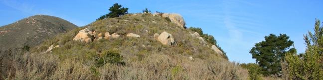
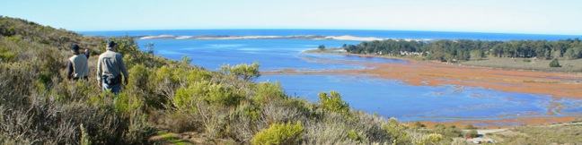
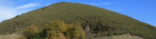
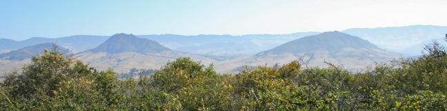
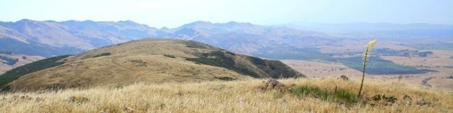
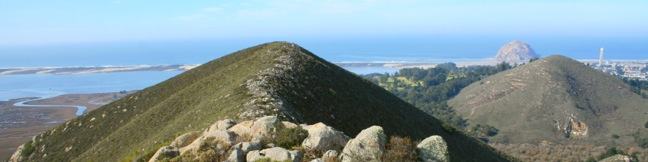
Nine principle volcanic plugs are spread between the central coast cities of Morro Bay and San Luis Obispo. The 911-foot Cerro Cabrillo (or Cabrillo Peak) is the third of the Nine Sisters from the west after Morro Rock and Black Hill. The summit of Cerro Cabrillo is the highest point in Morro Bay State Park, offering panoramic oceanfront views.  The unmaintained trail to the summit passes... Read more.
My Hikes: Completed hikeA green icon of shows a picture of a landscape with a check mark in the upper right corner, signifying that this is a hike you would like to put on your completed list.OK! Add to trails I've hiked
My Hikes: Want to hikeA green icon of shows a picture of a landscape with a heart in the upper right corner, signifying that this is a hike you would like to put on your to-do list.OK! Add to trails I want to hike
TagsA green icon depicting a tags represents a list of words and phrases that this content is tagged with Tagged with · California State Parks · Free Trails · Morro Bay · Morro Bay State Park · Morros · Ocean Views · Off Trail · Summits
Hike DistanceA green icon of a hiker used to label information about the length of the hike Distance: 2.5 miles · Elevation change: 900 feet
By: Published: Last updated: June 7, 2017
Turtle Rock Chorro Trail Morro Bay State Park San Luis Obispo hike California Morro Estuary Los Osos
If you are looking for an easy 45-minute hike to the top of a pimple of a hill between two of San Luis Obispo's Nine Sisters, take Chorro Trail to Turtle Rock in Morro Bay State Park. This 2.1-mile round trip hike begins with views of the estuary feeding Morro Bay and ends atop a small rise between Black Hill and Cerro Cabrillo. There is only 200 feet of elevation gain along the way, making... Read more.
My Hikes: Completed hikeA green icon of shows a picture of a landscape with a check mark in the upper right corner, signifying that this is a hike you would like to put on your completed list.OK! Add to trails I've hiked
My Hikes: Want to hikeA green icon of shows a picture of a landscape with a heart in the upper right corner, signifying that this is a hike you would like to put on your to-do list.OK! Add to trails I want to hike
TagsA green icon depicting a tags represents a list of words and phrases that this content is tagged with Tagged with · California State Parks · Free Trails · Morro Bay · Morro Bay State Park · Morteros · Ocean Views
Hike DistanceA green icon of a hiker used to label information about the length of the hike Distance: 2.1 miles · Elevation change: 200 feet
By: Published: Last updated: May 20, 2017
Portola Point Trail Morro Bay State Park San Luis Obispo hike California Portola Hill Morro Estuary view
It can feel like stealing when you snag great views from an easy hike. This is the situation on the 2-mile loop to Portola Point in Morro Bay State Park, which ascends 315 feet to panoramic views over Morro Bay. The view-to-effort ratio on this hike is quite favorable, almost criminal. Portola Hill is a dome-shaped volcanic rise on the eastern edge of Morro Estuary. The 329-foot hill is... Read more.
My Hikes: Completed hikeA green icon of shows a picture of a landscape with a check mark in the upper right corner, signifying that this is a hike you would like to put on your completed list.OK! Add to trails I've hiked
My Hikes: Want to hikeA green icon of shows a picture of a landscape with a heart in the upper right corner, signifying that this is a hike you would like to put on your to-do list.OK! Add to trails I want to hike
TagsA green icon depicting a tags represents a list of words and phrases that this content is tagged with Tagged with · California State Parks · Free Trails · Morro Bay · Morro Bay State Park · Ocean Views · Summits
Hike DistanceA green icon of a hiker used to label information about the length of the hike Distance: 2 miles · Elevation change: 315 feet
By: Published: Last updated: May 20, 2017
Eagle Rock Nature Trail Loop El Chorro regional Park hike San Luis Obispo Morro Bay Highway One
Along Highway One between San Luis Obispo and Morro Bay, is a regional park with over 700 acres of land that were formerly part of Camp San Luis. The versatile El Chorro Regional Park sports a 63-site campground, a botanical garden, playground, picnic area, dog park, volleyball courts, ball fields, and Dairy Creek Golf Course. Additionally, the park hosts a 2.4-mile loop to Eagle Rock... Read more.
My Hikes: Completed hikeA green icon of shows a picture of a landscape with a check mark in the upper right corner, signifying that this is a hike you would like to put on your completed list.OK! Add to trails I've hiked
My Hikes: Want to hikeA green icon of shows a picture of a landscape with a heart in the upper right corner, signifying that this is a hike you would like to put on your to-do list.OK! Add to trails I want to hike
TagsA green icon depicting a tags represents a list of words and phrases that this content is tagged with Tagged with · El Chorro Regional Park · Free Trails · Morteros · Nature Trails
Hike DistanceA green icon of a hiker used to label information about the length of the hike Distance: 2.4 miles · Elevation change: 450 feet
By: Published: Last updated: May 20, 2017
Sydney Street Trail Murray Hill San Luis Obispo Hike
If the hike at your own risk sign at the start of Sydney Trail doesn't intimidate you, maybe the 1,275-foot climb over 1.4 miles (one-way) will. This is a steep hike up a rocky road. The destination is a stone seating area at the top of Murray Hill (also known as Unnamed Hill), a 1,715-foot summit in the Santa Lucia Foothills with panoramic views over San Luis Obispo, more commonly reached... Read more.
My Hikes: Completed hikeA green icon of shows a picture of a landscape with a check mark in the upper right corner, signifying that this is a hike you would like to put on your completed list.OK! Add to trails I've hiked
My Hikes: Want to hikeA green icon of shows a picture of a landscape with a heart in the upper right corner, signifying that this is a hike you would like to put on your to-do list.OK! Add to trails I want to hike
TagsA green icon depicting a tags represents a list of words and phrases that this content is tagged with Tagged with · Free Trails · Summits
Hike DistanceA green icon of a hiker used to label information about the length of the hike Distance: 2.8 miles · Elevation change: 1275 feet
By: Published: Last updated: February 12, 2019
Islay Hill Trail San Luis Obispo Islay Hill Open Space hike Morros Nine Sisters SLO
Islay Hill stands at the eastern end of the chain of volcanic plugs running across San Luis Obispo. If Bishop Peak is the most iconic Morro, than Islay Hill is about the easiest to hike (with the exception of Black Hill). The dome-shaped 776-foot summit is more mound than mountain, but you will find 550 feet of elevation gain on the 1.8-mile round trip hike to the top. Since Islay Hill is... Read more.
My Hikes: Completed hikeA green icon of shows a picture of a landscape with a check mark in the upper right corner, signifying that this is a hike you would like to put on your completed list.OK! Add to trails I've hiked
My Hikes: Want to hikeA green icon of shows a picture of a landscape with a heart in the upper right corner, signifying that this is a hike you would like to put on your to-do list.OK! Add to trails I want to hike
TagsA green icon depicting a tags represents a list of words and phrases that this content is tagged with Tagged with · Free Trails · Morros
Hike DistanceA green icon of a hiker used to label information about the length of the hike Distance: 1.8 miles · Elevation change: 550 feet
By: Published: Last updated: April 2, 2019
Froom Creek Trail Irish Hills San Luis Obispo hike Froom Canyon
On the east side of the Irish Hills, there is a canyon with a surprisingly southwestern feel. Though surrounded by traditional coastal chaparral, the trail follows an old road up a canyon akin to the old mining roads converted into hiking trails found in the California desert. Above the canyon, there are broad views of San Luis Obispo's most prominent Morros, Bishop Peak and Cerro San Luis. ... Read more.
My Hikes: Completed hikeA green icon of shows a picture of a landscape with a check mark in the upper right corner, signifying that this is a hike you would like to put on your completed list.OK! Add to trails I've hiked
My Hikes: Want to hikeA green icon of shows a picture of a landscape with a heart in the upper right corner, signifying that this is a hike you would like to put on your to-do list.OK! Add to trails I want to hike
TagsA green icon depicting a tags represents a list of words and phrases that this content is tagged with Tagged with · Free Trails · Irish Hills
Hike DistanceA green icon of a hiker used to label information about the length of the hike Distance: 3 miles · Elevation change: 500 feet
By: Published: Last updated: April 2, 2019
Morro View Irish Hills hike San Luis Obispo Mariposa Trail Prefumo Canyon Irish Hills Natural Reserve hiking SLO
An expansive network of trails explore the thousand-foot ridges that make up the Irish Hills southwest of San Luis Obispo. While the regions notable chain of volcanic peaks gather greater attention from hikers, you can actually get a great view of the Morros from the Irish Hills, with smaller crowds. From Prefumo Canyon, one of the two main trailheads in the Irish Hills Natural Reserve,... Read more.
My Hikes: Completed hikeA green icon of shows a picture of a landscape with a check mark in the upper right corner, signifying that this is a hike you would like to put on your completed list.OK! Add to trails I've hiked
My Hikes: Want to hikeA green icon of shows a picture of a landscape with a heart in the upper right corner, signifying that this is a hike you would like to put on your to-do list.OK! Add to trails I want to hike
TagsA green icon depicting a tags represents a list of words and phrases that this content is tagged with Tagged with · Free Trails · Irish Hills
Hike DistanceA green icon of a hiker used to label information about the length of the hike Distance: 3.15 miles · Elevation change: 850 feet
By: Published: Last updated: April 2, 2019
Reservoir Canyon Trail summit hike Reservoir Creek Falls San Luis Obispo California Reservoir Canyon Natural Reserve hiking Murray Hill
From a less heralded summit in the Santa Lucia Foothills northeast of San Luis Obispo, you will find triumphant views of the peaks and valleys surrounding this gem on the Central Coast. The hike from Reservoir Canyon to this 1,715-foot crown is not for the meek. The 5.35-mile round trip hike ascends 1,350 feet, and over 800 of those feet come in the final grueling mile. The effort is... Read more.
My Hikes: Completed hikeA green icon of shows a picture of a landscape with a check mark in the upper right corner, signifying that this is a hike you would like to put on your completed list.OK! Add to trails I've hiked
My Hikes: Want to hikeA green icon of shows a picture of a landscape with a heart in the upper right corner, signifying that this is a hike you would like to put on your to-do list.OK! Add to trails I want to hike
TagsA green icon depicting a tags represents a list of words and phrases that this content is tagged with Tagged with · Creeks · Free Trails · Reservoir Canyon Natural Reserve · Summits · Waterfalls
Hike DistanceA green icon of a hiker used to label information about the length of the hike Distance: 5.35 miles · Elevation change: 1350 feet
By: Published: Last updated: February 13, 2019
Knapps Castle Trail Santa Barbara ruins Camino Cielo hike
In the mountains above Santa Barbara, a plot of privately owned land surrounded by the Los Padres National Forest. On that land stand the remains of a palatial estate that burned down seventy years ago, the so-called Knapp's Castle. To the ruins and back is a 0.8-mile round trip hike with 50 feet of elevation change. The majestic views from this unique spot far exceed the effort. From... Read more.
My Hikes: Completed hikeA green icon of shows a picture of a landscape with a check mark in the upper right corner, signifying that this is a hike you would like to put on your completed list.OK! Add to trails I've hiked
My Hikes: Want to hikeA green icon of shows a picture of a landscape with a heart in the upper right corner, signifying that this is a hike you would like to put on your to-do list.OK! Add to trails I want to hike
TagsA green icon depicting a tags represents a list of words and phrases that this content is tagged with Tagged with · Los Padres National Forest · Ruins · Santa Ynez Mountains
Hike DistanceA green icon of a hiker used to label information about the length of the hike Distance: 0.8 miles · Elevation change: 50 feet
By: Published: Last updated: January 17, 2018