Wall Street Mill Trail Joshua Tree National Park - hike - California - Queen Valley - Wonderland of Rocks - trek
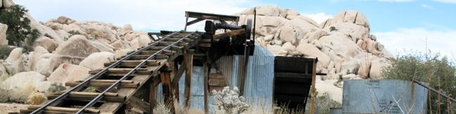
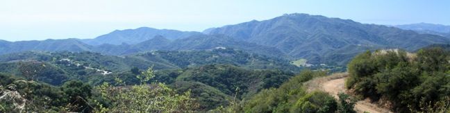
For the first half of the 20th century, the desert land now known as Joshua Tree National Park was scattered with miners on the hunt for gold and silver. When ore was mined, it was sent to a mill to be crushed and have the precious metal extracted. The ore from Desert Queen Mine and other mining operations passed through Wall Street Mill, which is located in Queen Valley near the Wonderland... Read more.
By: Published: Last updated: January 16, 2020
Contact Mine in Joshua Tree National Park: Contact Mine was in operation at the start of the 20th century, extracting gold and silver from the mountains south of Twentynine Palms, California. A hundred years of desert decay have left the mine rusty but recognizable. The old road to the mine is worn down and eroded, now a little-used trail that provides access to hikers. This 3.95-mile round trip trek ascends 710 feet up a wash, a canyon, and an old road to a mountainside mine site that offers a glimpse into the mining history of Joshua Tree National Park.
Contact Mine was in operation at the start of the 20th century, extracting gold and silver from the mountains south of Twentynine Palms, California. A hundred years of desert decay have left the mine rusty but recognizable. The old road to the mine is worn down and eroded, now just a little-used hiking trail. This 3.95-mile round trip trek ascends 700 feet up a wash, a canyon, and an old... Read more.
By: Published: Last updated: January 16, 2020
Arch Rock Trail Joshua Tree National Park White Tank Granite Arch Rock Hike Arch Rock Joshua Tree
Want to see a natural arch in Joshua Tree National Park? Take a short hike to Arch Rock within the granite formations surrounding White Tank Campground. An easy and enjoyable 0.3-mile loop leaving the campground is a must-do stroll for anyone staying at White Tank Campground. Other park visitors can now enjoy a 1.3-mile lollipop loop hike that begins from a trailhead along Pinto Basin... Read more.
By: Published: Last updated: May 13, 2025
Nojoqui Falls Park Trail Solvang Santa Barbara Hike
Nojoqui Falls Parks is located just off Highway 101 north of the Gaviota Tunnel between Santa Barbara and Buellton. In addition to picnic tables and playing fields, the park offers a short hike to an eighty-foot waterfall. This two-thirds of a mile round trip trail ascends 175 feet up a shaded canyon to the enchanting Nojoqui Falls. Nojoqui Falls Trail There are no junctions on the... Read more.
By: Published: Last updated: June 2, 2017
Gaviota Peak Trespass Trail Los Padres Santa Barbara hike - Gaviota Peak sits at the lofty west end of the Santa Ynez Mountains behind Santa Barbara. The 2,458-foot peak is just two miles from the Pacific Ocean, putting it in prime position to offer eye-popping views. There are two routes to the summit from the trailhead in Gaviota State Park. The traditional Gaviota Peak Trail is 3.15 miles one-way, while the immensely scenic Trespass Trail is 3.35 miles one-way - a superb 6.5-mile loop with 2,150 feet of elevation gain
Gaviota Peak sits at the lofty west end of the Santa Ynez Mountains behind Santa Barbara. The 2,458-foot peak is just two miles from the Pacific Ocean, putting it in prime position to offer eye-popping views. There are two routes to the summit from the trailhead in Gaviota State Park. The traditional Gaviota Peak Trail is 3.15 miles one-way, while the immensely scenic Trespass Trail is 3.35... Read more.
By: Published: Last updated: January 9, 2018
McMenemy Trail Montecito hike Los Padres National Forest Overlook Santa Ynez Mountains San Ysidro Canyon Trail, Santa Barbara, California
This 3.7-mile hike combines four trails (San Ysidro Canyon Trail, McMenemy Trail, Girard Trail, and Edison Catway Fire Road) to form a loop through the mountains behind Montecito, California. The trails ascend 1,000 feet, providing good exercise and views. From San Ysidro Trailhead, begin hiking inland on the wide trail that passes through a neighborhood before reaching Los Padres National... Read more.
By: Published: Last updated: June 2, 2017
Santa Barbara Outdoors Tequepis Trail Santa Ynez Mountains hike Lake Cachuma Circle V Camp
Tequepis Trail begins near the shores of Lake Cachuma and ascends the north side of the Santa Ynez Mountains behind Santa Barbara. The trail up offers views of the lake and valley, and there are broader ocean views from the top. This is an invigorating 8.4-mile round trip hike with 2,300 feet of elevation gain. To reach Tequepis Trail, start at the free parking lot at the entrance of... Read more.
By: Published: Last updated: June 2, 2017
Santa Ynez Canyon Trail to Eagle Rock in Topanga State Park in the Santa Monica Mountains, Los Angeles, Vereda de La Montura, Pacific Palisades, Sunset Boulevart, Hike, trail, sandstone summit
The craggy sandstone summit of Eagle Rock rises over Topanga State Park, delivering panoramic views of the Santa Monica Mountains. The shortest trail to awesome prominence is a four-mile hike from Trippet Ranch to Eagle Rock. For a more challenging trek, explore this 7.4-mile round trip hike ascending 1,400 feet from Santa Ynez Canyon to the 1,957-foot summit of Eagle Rock. Begin by... Read more.
By: Published: Last updated: May 13, 2025
Upper Solstice Canyon Trail Malibu Castro Crest from Corral Canyon Road through Upper Solstice Canyon in the Santa Monica Mountains
Between Corral Canyon Road and Castro Crest, the Backbone Trail passes though a remote segment of the Santa Monica Mountains know as Upper Solstice Canyon. While it is possible to feel quite removed at the bottom of this trail, the high ridges on both ends provide such sweeping views as to immediately restore your sense of place. From Corral Canyon Road to Castro Crest is 5.5 miles round... Read more.
By: Published: Last updated: December 7, 2018
Castro Crest from Latigo Canyon Road Malibu hike Castro Crest Backbone Trail Santa Monica Mountains
Castro Crest is located 1.4 miles from Latigo Canyon Road up a pleasant section of the Backbone Trail. The crest offers excellent views over Malibu's Santa Monica Mountains, with the option to continue another half-mile up Castro Peak. The summit may not be reached however, as it is privately owned and extremely closed to the public. Another popular extension is to continue on the Backbone... Read more.
By: Published: Last updated: June 2, 2017