Powell Butte Hike Mountain View Trail Summit Lane Portland Oregon
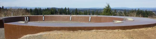
Are you in Portland, Oregon? Is it a clear day? If you answered yes to these questions, start making your way to Powell Butte. Located on the southeast side of the city, the butte is kept green by a 612-acre municipal park that offers several hiking trails for visitors. A short walk up a paved trail from the visitor center leads to the butte's 630-foot summit, which can offer salivating... Read more.
OK! Add to trails I’ve hiked
OK! Add to trails I want to hike
Tagged with · Buttes · Free Trails · Portland · Powell Butte Nature Park · Southeast Portland
Distance: 2.15 miles · Elevation change: 165 feet
By: Published: Last updated: May 13, 2025
White Domes Trail Valley of Fire State Park White Domes Loop Nevada Valley of Fire White Domes Hike
White Domes Trail crosses stunning landscapes that reinvent themselves around every turn. The views on this 1.1-mile loop with 150 feet of elevation change are both varied and extraordinary. The circuit passes sandstone formations with different shapes and colors. The trail also visits an old film set and lets hikers slip through a narrow canyon. The surroundings are diverse and the hike is... Read more.
OK! Add to trails I’ve hiked
OK! Add to trails I want to hike
Tagged with · Arches · Nevada State Parks · Overton
Distance: 1.1 miles · Elevation change: 150 feet
By: Published: Last updated: January 9, 2018
Fire Wave Trail Valley of Fire State Park Nevada Valley of Fire Wave Hike
Stripes are something you don't see too often in nature (unless you live near a bunch of zebras), and the stripes at Fire Wave really stand out. In this isolated area of Valley of Fire State Park in Nevada, the slickrock has interchanging streaks of beige and red-orange colored sandstone. Fire Wave has a bowl-shaped depression with a couple rising points covered with wavy lines. If you... Read more.
OK! Add to trails I’ve hiked
OK! Add to trails I want to hike
Tagged with · Nevada State Parks · Overton
Distance: 1.5 miles · Elevation change: 175 feet
By: Published: Last updated: April 19, 2018
Rainbow Vista Trail Valley of Fire State Park Nevada Rainbow Vista Hike
You have to use some pretty colorful language when describing Rainbow Vista Trail, like vibrant, fiery, and effing extraordinary. The good news about Rainbow Vista Trail is that you get big views right from the start and any hiking you do will be picturesque. The bad news is that Rainbow Vista Trail is not as well marked as it could be and crosses sandy terrain with lots of spurious... Read more.
OK! Add to trails I’ve hiked
OK! Add to trails I want to hike
Tagged with · Nevada State Parks · Overton
Distance: 1.5 miles · Elevation change: 150 feet
By: Published: Last updated: September 11, 2019
Mouse's Tank Trail Petroglyphs Canyon Trail Hike to Mouses Tank Valley of Fire State Park Nevada
The best outing for seeing petroglyphs in Valley of Fire State Park is Petroglyph Canyon Trail. This 0.75-mile round trip hike passes rock faces that are covered in Native American rock art. The abundance of prehistoric petroglyphs on this trail is amazing. To cap things off, the trail ends at Mouse's Tank, a natural basin (or tinaja) of water suspended in sandstone. Mouse's Tank is a nice... Read more.
OK! Add to trails I’ve hiked
OK! Add to trails I want to hike
Tagged with · Desert Canyons · Nevada State Parks · Petroglyphs · Tanks
Distance: 0.75 miles · Elevation change: 25 feet
By: Published: Last updated: November 9, 2018
Atlatl Rock Trail Petroglyphs Hike Valley of Fire State Park Nevada
Valley of Fire State Park is an excellent place to see Native American rock art up close. Atlatl Rock sports a collection of petroglyphs on a boulder about fifty feet off the ground. A metal staircase has been installed on the side of the red sandstone formation to take visitors right up to a viewing area in front of the petroglyphs. Atlatl Rock is on a Scenic Loop Road on the west side of... Read more.
OK! Add to trails I’ve hiked
OK! Add to trails I want to hike
Tagged with · Nevada State Parks · Overton · Petroglyphs
Distance: 0.1 miles · Elevation change: 50 feet
By: Published: Last updated: November 9, 2018
Petrified Logs Loop Petrified Wood Trail Valley of Fire State Park Hike Nevada
Petrified wood is the fossil of a tree that has been turned to stone. Find out how this happens and see partially buried petrified logs in Valley of Fire State Park in Nevada. An easy 0.3-mile loop goes past several good examples of petrified logs, as well as informative panels detailing how the park's petrified logs came to be. Petrified Logs Loop is located on the southwest side of... Read more.
OK! Add to trails I’ve hiked
OK! Add to trails I want to hike
Tagged with · Nevada State Parks · Overton · Petrified Logs
Distance: 0.3 miles · Elevation change: 45 feet
By: Published: Last updated: May 13, 2025
Balancing Rock Trail Valley of Fire State Park Balancing Rock Hike Nevada Valley of Fire State Park Visitor Center Balanced Rock
This short hike begins next to the visitor center for Valley of Fire State Park. Hike just a quarter mile round trip to stand below a formation of red sandstone that seems to be standing quite precariously. The short trail is located near the start of White Domes Road and is an easy and convenient addition to any park visit. Facing the visitor center, turn to the left to spot the start... Read more.
OK! Add to trails I’ve hiked
OK! Add to trails I want to hike
Tagged with · Nevada State Parks · Overton
Distance: 0.25 miles · Elevation change: 10 feet
By: Published: Last updated: April 4, 2017
Elephant Rock Trail Valley of Fire State Park Elephant Rock Hike Nevada Valley of Fire State Park
Elephant Rock is a unique rock formation just off Valley of Fire Highway, next to the east entrance of Valley of Fire State Park. This is the sort of sandstone formation that can't be believed by people who haven't seen it. Is Elephant Rock an oddly shaped natural arch or perhaps a stone encased mastodon trunk? Get a close look at Elephant Rock on an easy 0.3-mile hike. Start from a... Read more.
OK! Add to trails I’ve hiked
OK! Add to trails I want to hike
Tagged with · Arches · Nevada State Parks · Overton
Distance: 0.3 miles · Elevation change: 50 feet
By: Published: Last updated: January 9, 2018
Strawberry Peak Trail San Gabriel Mountains Angeles National Forest Strawberry Peak Hike
Strawberry Peak holds the distinction of being the highest summit in the front range of the San Gabriel Mountains, besting nearby San Gabriel Peak by a just a yard. Measuring 6,164 feet tall, Strawberry Peak is taller than other surrounding mountains like Josephine Peak, Mount Lawlor, and Mount Wilson. A hike to the summit from Red Box Picnic Area on Angeles Crest Highway is 7.5 miles round... Read more.
By: Published: Last updated: May 13, 2025