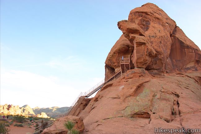
Valley of Fire State Park is an excellent place to see Native American rock art up close. Atlatl Rock sports a collection of petroglyphs on a boulder about fifty feet off the ground. A metal staircase has been installed on the side of the red sandstone formation to take visitors right up to a viewing area in front of the petroglyphs. Atlatl Rock is on a Scenic Loop Road on the west side of the park next to Atlatl Rock Campground and is a great, quick attraction in Valley of Fire State Park.
The trail to Atlatl Rock is only about 250 feet long and most of that is stairs. Get started from Atlatl Rock Picnic Area, which has picnic tables, shade canopies, barbecue grills, water spigots, and vault toilets. The staircase up to the petroglyphs is visible on the drive to the picnic area, so finding the trail won’t be a challenge. Follow the trail south for fifty yards to hit the base of a staircase painted red-orange to match the surrounding stone.

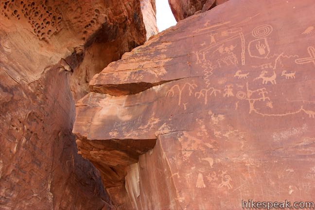
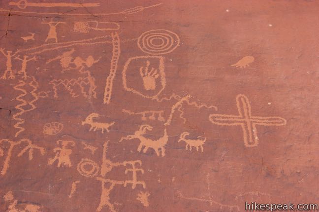
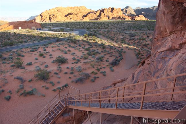
Go up the steps through a couple twists to come up to a viewing platform. Stand on the metal deck in front of a well-preserved collection of symbols carved onto a dark patch of rock. The petroglyphs are easy to see because they were carved into a natural layer of darker material called desert varnish, exposing red-orange rock underneath.

Petroglyphs cover the boulder in front of the viewing platform, depicting people, animals, and symbols. Toward the top of rock, you’ll see a pair of horizontal carvings representing an atlatl and a spear. A panel at Atlatl Rock explains that:
An atlatl is a throwing stick or a dart thrower used by ancient tribes to give more force to their darts or spears. It was usually a wooden stick about two feet long with a handhold on one end and a hook on the other end. A slot cut in the tail end of the dart was set against the hook, allowing the dart to lie along the atlatl so that both could be grasped midway of the dart by the user.

Having tools like atlatls must have been very useful to the people that lived in this tough desert area in centuries past. The petroglyphs on Atlatl Rock are over 4,000 years old. While the meaning of the images has been lost, they offer an interesting link to these ancient cultures. What story do the petroglyphs tell you?
From this perch at the top of the staircase, you can look out from the rock, enjoying a raised perspective across the desert landscape toward surrounding ridges of red sandstone. The park’s main campground, Atlatl Rock Campground, is backed up against the formations to the right.

When you are done checking out the rock art on Atlatl Rock, return the way your came to complete this short hike of a tenth of a mile round trip. Coming down the staircase, look to your right to spot even more petroglyphs. Rock art can be found throughout the area.
An entrance fee is charged to visit Valley of Fire State Park, but no permit is needed to check out Atlatl Rock. Continue down Scenic Loop Road past Atlatl Rock to see Arch Rock, a natural arch in a rock formation right along the road. Do not vandalize the petroglyphs and respect their antiquity. Nevada State Parks requests that visitors help preserve these petroglyphs.
In order to protect these cultural treasures, we ask that you do not walk on, touch, or deface the rock. Help us protect our petroglyphs for others to enjoy for generations to come.
To get to the trailhead: From Las Vegas, take Interstate 15 north for about 35 miles to exit 75 (signs for Valley of Fire State Park and Lake Mead National Recreation Area). At the end of the offramp, continue southeast on Valley of Fire Highway. Reach the park’s west entrance after 14.5 miles. Drive another 1.8 miles and turn left onto Scenic Loop Road (Campground Road), which will be the first paved road on the left, directly across from a gravel road to Petrified Logs Loop. Drive half a mile, passing the entrance to Atlatl Rock Campground, and turn left into the parking area below Atlatl Rock.
Trailhead address: Scenic Loop Road, Valley of Fire State Park, Overton, NV 89040
Trailhead coordinates: 36.42306, -114.550535 (36° 25′ 23.01″N 114° 33′ 01.92″W)
You may also view a regional map of surrounding Nevada trails and campgrounds.
 | Petrified Logs Loop This 0.3-mile hike gets close to petrified logs on the desert floor passing panels that explain how wood is petrified. |
 | Balancing Rock This 0.25-mile hike, which begins next to the Valley of Fire State Park Visitor Center, approaches a rock formation that appears to stand with a bit of magic. |
 | Elephant Rock This 0.3-mile hike at the east entrance of Valley of Fire State Park leads to a sandstone formation resembling an elephant with a unique natural arch for a trunk. |
 | Petroglyph Canyon Trail to Mouse's Tank This 0.75-mile hike travels down a sandy path lined with petroglyphs to a natural basin formed in the sandstone. |
 | Rainbow Vista This scenic hike of up to 1.5 miles explores multi-colored landscapes, crossing through sandstone formations to summit a short crest with tremendous 360-degree views and the option to continue to Fire Canyon Overlook. |
 | Fire Wave This 1.5-mile hike reaches a sensational striped creation where a slickrock depression is painted in waves of orange and beige. |
 | White Domes This 1.1-mile loop is impressive from start to finish as it explores colorful, intricate rock formations, passes and old film set, and slips through a narrow slot canyon. |
 | Hikes in Nevada Explore more trails in Nevada and the picturesque parks around Las Vegas. |
 | Atlatl Rock Campground and Arch Rock Campground Valley of Fire State Park has great places to camp surrounded by formations of red sandstone. |
 | Petroglyphs near Seventeen Mile Point in Mojave National Preserve (California) This quarter-mile path visits ancient engravings in the volcanic rock at the western rim of the cinder fields just off Kelbaker Road. |
 | Pictograph Trail in Anza-Borrego Desert State Park (California) This 1.8-mile hike visits rock paintings drawn by Kumeyaay Indians who lived in the Anza-Borrego Desert thousands of years ago. |
 | Barker Dam in Joshua Tree National Park (California) This level 1.5-mile loop visits a foreign-looking reservoir and petroglyphs engravings within the Wonderland of Rocks. |
 | Malama Trail (Hawaii) This 0.2 to 1.2-mile hike visits rare rock carvings in Puakō Petroglyph Archeological District on the west coast of the Big Island of Hawai'i. |


Is it worthy to visit this park and do some short hike like this one in First week of June?
[…] Petroglyphs at Atlatl Rock […]
[…] leading up the face of Atlatl Rock, where one can view ancient petroglyphs at Valley of Fire, […]
[…] that offer more than 70 campsites, all of which are equipped with fire rings and picnic tables. The Atlatl Rock campground is the most popular and has RV hookups, showers, and flush […]
[…] Atlatl Rock is known for its ancient petroglyphs. These carvings provide unique photographic opportunities as they tell stories of the park’s rich history […]