Hazard Peak Bloody Nose Trail Hiedra Trail Hazard Peak Trail Hike Montaña de Oro State Park Hike California
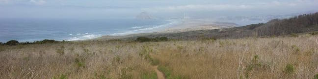
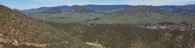
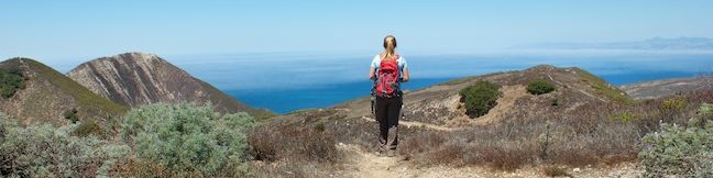
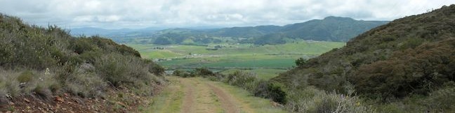
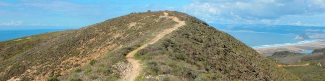
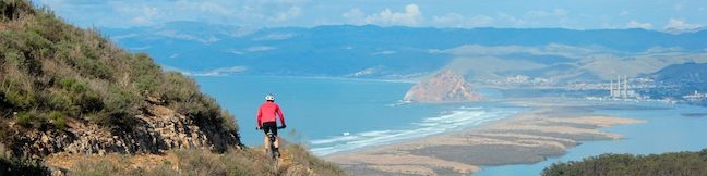
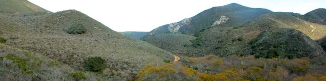
The panoramic summit of Hazard Peak in Montaña de Oro State Park has excellent coastal views. Hazard Peak Trail is the most obvious route to the top and a great choice, rising to the 1,076-foot summit over 3 miles. A junction partway up Hazard Peak Trail makes it possible to add a couple other trails to the approach. Bloody Nose Trail and Hiedra Trail are a combined 0. ...Read more.
My Hikes: Completed hikeA green icon of shows a picture of a landscape with a check mark in the upper right corner, signifying that this is a hike you would like to put on your completed list.OK! Add to trails I've hiked
My Hikes: Want to hikeA green icon of shows a picture of a landscape with a heart in the upper right corner, signifying that this is a hike you would like to put on your to-do list.OK! Add to trails I want to hike
TagsA green icon depicting a tags represents a list of words and phrases that this content is tagged with Tagged with · California State Parks · Free Trails · Irish Hills · Los Osos · Ocean Views · Montaña de Oro State Park
Hike DistanceA green icon of a hiker used to label information about the length of the hike Distance: 5.55 miles · Elevation change: 950 feet
By: Published: Last updated: December 6, 2025
South Dune Trail Bloody Nose Trail Hiedra Trail Hazard Peak Trail Loop Montaña de Oro State Park Hike Hiedra Trail Loop Los Osos California
Hikes in Montaña de Oro State Park travel along the coast or delve inland into canyons and up peaks. If you want a mix of hiking environments, consider this four-trail loop, which combines South Dune Trail, Bloody Nose Trail, Hiedra Trail, and Hazard Peak Trail for a 2 2/3 mile round trip hike with a little over 300 feet of elevation change. This loop can be added to the hike up Hazard Peak, adding a loop to summit hike for a just over 6. ...Read more.
My Hikes: Completed hikeA green icon of shows a picture of a landscape with a check mark in the upper right corner, signifying that this is a hike you would like to put on your completed list.OK! Add to trails I've hiked
My Hikes: Want to hikeA green icon of shows a picture of a landscape with a heart in the upper right corner, signifying that this is a hike you would like to put on your to-do list.OK! Add to trails I want to hike
TagsA green icon depicting a tags represents a list of words and phrases that this content is tagged with Tagged with · California State Parks · Free Trails · Irish Hills · Los Osos · Ocean Views · Montaña de Oro State Park
Hike DistanceA green icon of a hiker used to label information about the length of the hike Distance: 2.67 miles · Elevation change: 310 feet
By: Published: Last updated: December 5, 2025
Old Prospector Trail Pond Trail Loop Irish Hills Natural Area San Luis Obispo Prospector Hill Hike
Today the Irish Hills are like a gold mine for hikers, but the small mountain range in San Luis Obispo historically hosted several mines for chromium and mercury. The ruins of one of these mines can be visited on Old Prospector Trail, which opened in 2015 to join the growing group of trails in Irish Hills Natural Reserve. This hikers-only single track starts in Froom Canyon and is 0. ...Read more.
My Hikes: Completed hikeA green icon of shows a picture of a landscape with a check mark in the upper right corner, signifying that this is a hike you would like to put on your completed list.OK! Add to trails I've hiked
My Hikes: Want to hikeA green icon of shows a picture of a landscape with a heart in the upper right corner, signifying that this is a hike you would like to put on your to-do list.OK! Add to trails I want to hike
TagsA green icon depicting a tags represents a list of words and phrases that this content is tagged with Tagged with · Free Trails · Irish Hills · Mines · Ruins
Hike DistanceA green icon of a hiker used to label information about the length of the hike Distance: 4.4 miles · Elevation change: 650 feet
By: Published: Last updated: December 5, 2025
Oats Peak Trail Montaña de Oro State Park summit hike New Oats Peak Trail San Luis Obispo California
Oats Peak is the second highest summit in Montaña de Oro State Park, a full 26 feet taller than Valencia Peak, which is probably the park's favorite summit for hikers. Oats Peak is located a couple miles inland of Valencia Peak, sporting smaller ocean views and greater views over the Irish Hills, the canyons and ridges making up the interior of the Montaña de Oro State Park. ...Read more.
My Hikes: Completed hikeA green icon of shows a picture of a landscape with a check mark in the upper right corner, signifying that this is a hike you would like to put on your completed list.OK! Add to trails I've hiked
My Hikes: Want to hikeA green icon of shows a picture of a landscape with a heart in the upper right corner, signifying that this is a hike you would like to put on your to-do list.OK! Add to trails I want to hike
TagsA green icon depicting a tags represents a list of words and phrases that this content is tagged with Tagged with · California State Parks · Free Trails · Irish Hills · Los Osos · Summits · Montaña de Oro State Park
Hike DistanceA green icon of a hiker used to label information about the length of the hike Distance: 10.8 miles · Elevation change: 1325 feet
By: Published: Last updated: December 5, 2025
Reservoir Flats Trail Montaña de Oro State Park Islay Creek Canyon Islay Creek Campground hike
Montaña de Oro State Park has every type of hike you could want, ranging from easy oceanfront strolls to difficult summit ascents. If you're feeling like Goldilocks and want something in the middle (just right), check out Reservoir Flats Trail, a 2-mile loop with 200 feet of elevation gain that is conveniently located just behind the park visitor center. ...Read more.
My Hikes: Completed hikeA green icon of shows a picture of a landscape with a check mark in the upper right corner, signifying that this is a hike you would like to put on your completed list.OK! Add to trails I've hiked
My Hikes: Want to hikeA green icon of shows a picture of a landscape with a heart in the upper right corner, signifying that this is a hike you would like to put on your to-do list.OK! Add to trails I want to hike
TagsA green icon depicting a tags represents a list of words and phrases that this content is tagged with Tagged with · California State Parks · Free Trails · Irish Hills · Los Osos · Ocean Views · Montaña de Oro State Park
Hike DistanceA green icon of a hiker used to label information about the length of the hike Distance: 2 miles · Elevation change: 200 feet
By: Published: Last updated: December 9, 2025
Islay Creek Campground Montaña de Oro State Park Camping Los Osos Camp San Luis Obispo California
Montaña de Oro State Park preserves a stunning stretch of the California's Central Coast where the Irish hills meet the Pacific Ocean. Picturesque bluffs and sandy coves dominate the coastline. The inland side of the park has charming peaks and canyons. Within the park's largest canyon, Islay Creek Canyon, you'll find Islay Creek Campground. The conveniently-located campground is just a short walk from the beach at Spooner's Cove and can serve as a base camp for hikes on nearby trails like the Bluff Trail, Valencia Peak Trail, Hazard Peak Trail, Islay Creek Trail, and Oats Peak Trail. ...Read more.
TagsA green icon depicting a tags represents a list of words and phrases that this content is tagged with Tagged with · Irish Hills · Los Osos · Tent Camping · Montaña de Oro State Park
By: Published: Last updated: May 13, 2025
Johnson Ranch Open Space to Irish Hills Natural Reserve Connector Trail hike Froom Canyon San Luis Obispo California Froom Ranch to Johnson Ranch Connector
If one park is good, than two parks are better, and a trail between those parks brings out the best of both. Opened in the spring of 2013, the Connector Trail between Johnson Ranch Open Space and the Irish Hills Natural Reserve links two of San Luis Obispo County's great parks. The new trail also connects hikers with grassy slopes and oak-covered ridges with views across San Luis Obispo and Edna Valley. ...Read more.
My Hikes: Completed hikeA green icon of shows a picture of a landscape with a check mark in the upper right corner, signifying that this is a hike you would like to put on your completed list.OK! Add to trails I've hiked
My Hikes: Want to hikeA green icon of shows a picture of a landscape with a heart in the upper right corner, signifying that this is a hike you would like to put on your to-do list.OK! Add to trails I want to hike
TagsA green icon depicting a tags represents a list of words and phrases that this content is tagged with Tagged with · Free Trails · Irish Hills
Hike DistanceA green icon of a hiker used to label information about the length of the hike Distance: 5 miles · Elevation change: 575 feet
By: Published: Last updated: December 5, 2025
Hazard Peak Loop Hazard Peak Trail East Boundary Barranca Trail Islay Creek Trail Montaña de Oro State Park hike
The hike up and down Hazard Peak Trail delivers a heavy dose of ocean views. While it could be argued that this 6-mile round trip hike is the finest trek to the summit of Hazard Peak, you may wish to consider elongating that hike to a 9.2-mile loop that returns to the coast via Islay Creek Trail in the adjacent Islay Creek Canyon. Sacrificing a second helping of ocean views, the loop explores the secluded interior of Montaña de Oro State Park and finishes with a cool down on a wide, gradual trail in a canyon flanked by thousand foot peaks (including the 1,076-foot Hazard Peak). ...Read more.
My Hikes: Completed hikeA green icon of shows a picture of a landscape with a check mark in the upper right corner, signifying that this is a hike you would like to put on your completed list.OK! Add to trails I've hiked
My Hikes: Want to hikeA green icon of shows a picture of a landscape with a heart in the upper right corner, signifying that this is a hike you would like to put on your to-do list.OK! Add to trails I want to hike
TagsA green icon depicting a tags represents a list of words and phrases that this content is tagged with Tagged with · California State Parks · Free Trails · Irish Hills · Los Osos · Ocean Views · Summits · Montaña de Oro State Park
Hike DistanceA green icon of a hiker used to label information about the length of the hike Distance: 9.2 miles · Elevation change: 1000 feet
By: Published: Last updated: December 5, 2025
Hazard Peak Trail Montaña de Oro State Park summit hike
Montaña de Oro State Park is packed with so many picturesque places that it can be difficult to settle on just one day hike. However, if you are looking for broad, unobstructed view over Morro Bay, you should feel compelled to set out for the top of Hazard Peak. Looking north from this coastal 1,076-foot summit, you won't see anything even half as tall as Hazard Peak for about 15 miles, giving you a full view of the dune-lined coast backed by the iconic Morro Rock. ...Read more.
My Hikes: Completed hikeA green icon of shows a picture of a landscape with a check mark in the upper right corner, signifying that this is a hike you would like to put on your completed list.OK! Add to trails I've hiked
My Hikes: Want to hikeA green icon of shows a picture of a landscape with a heart in the upper right corner, signifying that this is a hike you would like to put on your to-do list.OK! Add to trails I want to hike
TagsA green icon depicting a tags represents a list of words and phrases that this content is tagged with Tagged with · California State Parks · Free Trails · Irish Hills · Los Osos · Ocean Views · Summits · Montaña de Oro State Park
Hike DistanceA green icon of a hiker used to label information about the length of the hike Distance: 6 miles · Elevation change: 950 feet
By: Published: Last updated: December 5, 2025
Islay Creek Trail Montaña de Oro State Park hike
Montaña de Oro State Park has a couple lengthy level hikes. If you desire ocean views, you can't do any better than the Bluff Trail. If you would rather hike up a canyon flanked by thousand foot peaks along a creek that even has a small waterfall, the fitting trail is Islay Creek Trail. The rolling 3-mile long dirt road has 300-feet of easy elevation change. ...Read more.
My Hikes: Completed hikeA green icon of shows a picture of a landscape with a check mark in the upper right corner, signifying that this is a hike you would like to put on your completed list.OK! Add to trails I've hiked
My Hikes: Want to hikeA green icon of shows a picture of a landscape with a heart in the upper right corner, signifying that this is a hike you would like to put on your to-do list.OK! Add to trails I want to hike
TagsA green icon depicting a tags represents a list of words and phrases that this content is tagged with Tagged with · California State Parks · Free Trails · Irish Hills · Los Osos · Ocean Views · Montaña de Oro State Park
Hike DistanceA green icon of a hiker used to label information about the length of the hike Distance: 6 miles · Elevation change: 300 feet
By: Published: Last updated: December 9, 2025

Tag!

You've come to a tag page, one of the blogiest ways to browse hikespeak.com.

Here are some more tags. The most common tags are the big ones at the top of the list. Have a look around. You may also find what you seek with the search feature on the Hike Finder Map.

Free TrailsNational ParksOcean ViewsCalifornia State ParksSummitsWaterfallsTent CampingCreeksLakesNature TrailsAngeles National ForestMalibuAdventure PassCascade RangeNew Zealand Department of ConservationDesert CanyonsOff TrailWildflowersBeachesLos Padres National ForestNew Zealand National ParksMountains Recreation and Conservation AuthoritySan Gabriel Mountains National MonumentGriffith ParkBig SurWheelchair-FriendlyCampervan CampingRuinsSequoia GrovesOregon State ParksLos OsosPacific Crest TrailHydrothermalCavesHollywoodBackpackingMontaña de Oro State ParkAustralian National ParksTopanga State ParkYosemite ValleyRedwood GrovesAltadenaSanta Ynez MountainsSanta Monica Mountains National Recreation AreaTopangaIrish HillsLone PineMalibu Creek State ParkBorrego SpringsAgoura HillsTrail CampArchesBureau of Land ManagementLookout TowersPacific PalisadesBoulderingDeschutes National ForestColumbia River Gorge National Scenic AreaBackbone TrailLavaWest Hills of PortlandMorrosTualatin MountainsArthur's Pass VillageMinesNevada State ParksTongariro National ParkMammoth LakesWalk-in CampingFruitaGrand JunctionArthur's Pass National ParkBendGiant ForestLa Cañada FlintridgeTide PoolsMorro BayCleveland National ForestRotoruaAzusaJohn Muir TrailAccommodationsOvertonArcadiaPasadenaZion CanyonLava TubesGoletaIsland in the SkyCalabasasTasmania's 60 Great Short WalksHot SpringsSanta Lucia MountainsClaremontGaviota State ParkBadlandsVerdugo MountainsBoardwalksGolden Trout WildernessClosedTillamookPhillip IslandAoraki Mount Cook National ParkRainforestsShasta-Trinity National ForestClosed SeasonallyVolcanoesNorthwest PortlandLas VegasSan Bernardino National ForestGrand Canyon of the YellowstoneForest ParkMount CookVolcanoNewbury ParkPetroglyphsGrant GroveGeyser BasinsStairsButtesBrentwoodGifford Pinchot National ForestFreycinet PeninsulaSan Ysidro MountainsColes BayMorro Bay State ParkTopatopa MountainsThousand OaksPalos Verdes PeninsulaSand DunesOakhurstOnondaga CountyAdirondack ParkAdirondack MountainsMorterosGiant Sequoia National MonumentAnsel Adams WildernessOhakuneOjaiMemorialsFreycinet National ParkLighthousesJohn Muir WildernessTasman PeninsulaTrabuco Ranger DistrictSan Bernardino MountainsWestern DivideSanta Ana MountainsSilver Moccasin TrailOrange County ParksPoint Mugu State ParkWestridge-Canyonback Wilderness ParkPaicinesSunriverWestern Divide Ranger DistrictNatural BridgesWill Rogers State ParkCratersNelder GroveTopanga CanyonStevensonWhakapapa VillageLava Butte Lava FlowWashington State ParksMount Hood National ForestCastle Crags State ParkMount ShastaThree Capes Scenic RouteNewberry National Volcanic MonumentWater SlidesMount HoodTarzanaContinental DivideSouth Lake TahoeSistersHobartReservoir Canyon Natural ReserveDomesPfeiffer Big Sur State ParkHumboldt Redwoods State ParkSouthwest PortlandOasesLeo Carrillo State ParkMoabGovernment CampNewhallLaguna BeachJulianSouth Coast WildernessTemescal Gateway ParkSilver Falls State ParkCambriaHutsSublimityGlacier LakesCliff JumpingGoing-to-the-Sun RoadPearblossomMontecitoHawaii State ParksKlamath MountainsSpringvilleRancho Palos VerdesWawonaDeschutes RiverCamp ShermanWildlife ViewingBeacon Rock State ParkLos Robles Open SpaceTanksYellowstone RiverSan Vicente Mountain ParkSwimming HolesObservatoriesIdyllwildSan Jacinto Ranger DistrictWaiotapuBurbankPalomar Ranger DistrictCalifornia Coastal TrailTasman National ParkLabrador Hollow Unique AreaCortland CountyTullyNew York State ForestsMount William National ParkVestalPicnic AreaWind CavesSan Jacinto MountainsSilver Peak WildernessBinghamton University Nature PreserveCedar GroveBlack HillsAvila BeachJulia Pfeiffer Burns State ParkCinder ConesLake ElsinoreMurrietaWenatche National ForestElephant SealsGlendaleSnowshoeingSan Mateo Canyon WildernessWilsons Promontory National ParkCrestlineEmma Wood State BeachWhananaki NorthCarpinteriaPlacerita Canyon Natural AreaPlacerita Canyon State ParkBike TrailSan PedroTujungaSanta Susana MountainsNew York State ParksSun ValleyCrescent CityRedwood Mountain GroveBishop Peak Natural ReserveAvila ValleySimi HillsSheep Mountain WildernessCrystal Cove State ParkSierra Pelona MountainsSanta MargaritaBeverly HillsConejo ValleyBlue Mountain LakeNicholas Flat Natural PreserveHume Lake Ranger DistrictGlaciersTe AwamutuRangitikeiSummit ValleySummit Valley Edmund D. Edelman ParkFish HatcheryWoodland HillsCastle Crags WildernessPepperwoodTryon Creek State Natural AreaTaurangaTaupoLodgeSanta PaulaTwentynine PalmsSherman OaksWillamette National ForestSouthern AlpsPortlandMount Thomas Forest Conservation AreaOkukuCusterCal PolyMacleay ParkWaimangu Volcanic ValleyPictographsOkere Falls Scenic ReserveOkere FallsArroyo GrandeMarvin Braude Mulholland Gateway ParkHood RiverEaglehawk NeckCampervan ReviewMount WellingtonWellington ParkTree MoldsLauncestonWaipio ValleyAndrew Molera State ParkCatalina IslandLimekiln State ParkHiloMount Field National ParkBritzRichardson Grove Redwoods State ParkColumbia River GorgeLake Tahoe Basin National Forest LandsPuakoCampervan RentalRocky MountainsLyleSaltwater RiverDeschutes River State Recreation AreaBlowholesWascoLord of the RingsBoat CruiseHarmony Headlands State ParkCayucosSanta Clarita Woodlands ParkAgua DulceCrazy Horse MemorialMonrovia Canyon ParkMonroviaRefugio State BeachPrimitive CampingSatellite CommunicatorsSOS BeaconsMount MaunganuiCulver CityHigh LineMatamataMount San Jacinto State ParkSan Jacinto WildernessMuruparaBanningFiscalini Ranch PreserveKings CanyonWhitewater RaftingTop 10 Holiday ParkPapamoaAerial GreenwayManhattanGPS NavigatorsPalomar MountainsAmboy Crater National Natural LandmarkPetrified LogsPowell Butte Nature ParkSoutheast PortlandBig Bear LakeCross Country SkiingCarpinteria Salt Marsh Nature ParkSonoraCarpinteria Bluffs Nature PreserveLas CrucesVentura RiverPilot Butte State ParkOak ParkMount Lowe RailwayLaguna Coast Wilderness ParkWarner SpringsOrangePeters Canyon Regional ParkSanta Lucia WildernessCarpinteria Seal SanctuaryGetty View ParkHearst San Simeon State ParkMalibu Lagoon State BeachKura Tawhiti / Castle Hill Conservation AreaCastle HillCentral ParkHuntington BeachAwbrey ButteHobbitonLiffeyFallbrookBerriedaleVasquez Rocks Natural Area ParkJamesvilleClark Reservation State ParkBeaver Lake Nature CenterBaldwinsvilleOnondaga County ParkWhitewater PreserveDocent-led HikesPlaya VistaAnaheimCataract Gorge ReserveSan SimeonTauwhara BayLiffey Falls State ReserveGreat Western TiersCape Woolamai State Faunal ReserveKoalasSaint Columba Falls State ReservePyenganaFallbrook Land ConservancyHokianga HarbourDouglas-Apsley National ParkBechinoOtamure BayOtamure Recreation ReserveYucca ValleySan Rafael HillsApp ReviewGuy W. Talbot State ParkEugeneMission Trails Regional ParkTurangiSanteeSanta Rosa and San Jacinto Mountains National MonumentGreen Lakes State ParkFayettevilleConcretionsMangawekaHuntervilleBel AirNewport BeachNewport BayJedediah Smith Redwoods State ParkSantiago Oaks Regional ParkMacKerricher State ParkSalt Point State ParkWeir Canyon Wilderness ParkB&BEl Capitán State BeachFreeride TrailsWest HillsBackpackers LodgeUpper Newport Bay Nature PreserveLake Tikitapu Scenic ReserveMotor LodgeSespe WildernessMyers FlatKlamath National ForestSeasideBaldwin Hills Scenic Overlook State ParkLaCrosseLas Virgines View ParkPalouse Falls State ParkArcoEl Chorro Regional ParkOregon CityWillamette RiverHappy ValleyCamassia Natural AreaWest LinnMontagueWeedCorbettGeorge Himes Nature ParkWeottOrickFort BraggJennerWhite SalmonCamasLacamas Lake Regional ParkPrairie Creek Redwoods State ParkMcKenzie BridgeDuartePalos Verdes EstatesThe Nature ConservancyLincoln CityDepoe BayCooke CityClatskanieGlenbrookCarson CityDevils TowerLake MichiganTuna Canyon ParkWelchesRhododendronOceansideNative American HeritageBass LakeStroller-FriendlyBisonDunsmuirSiletz Bay National Wildlife RefugeSanta ClaritaFishpondsKonaCastaicKohala Forest ReserveKenneth Hahn State Recreation AreaHonomuHollywood HillsStudio CityPu‘uhonua O Hōnaunau National Historical ParkHonaunauLongridge ParkYurtsBreaCape Meares State ParkArroyo Sequit ParkOceano Dunes State Vehicular Recreation AreaCape Lookout State ParkNipomoCannon BeachEldorado State ParkColorado State ParksBoulderMarquam Nature ParkShasta LakeCalaveras Big Trees State ParkMojave Trails National MonumentAtascaderoCape Kiwanda Natural AreaCucamonga WildernessPacific CityCarbon Canyon Regional ParkCape Meares State Scenic ViewpointEcola State ParkMosierSimi ValleyCanoe & KayakAdirondack High PeaksMonserate Mountain PreserveTumalo CreekMaricopaShevlin ParkKlamathPortervilleTualatin Hills Nature ParkBeavertonGarbervilleUpper Ojai ValleyArchie Briggs Natural AreaArboretumsPismo BeachAmboySan BernardinoSkyforestCascade LocksLake ArrowheadLake Placid