Marquam Nature Park Loop Hike West Hills Southwest Portland Oregon Marquam Trail
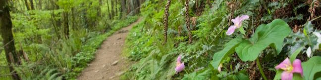
Marquam Nature Park is walking distance from downtown Portland, but is tucked away and remains less well known than other parks in the West Hills. Marquam Nature Park provides ample woodland solitude, despite its proximity to downtown. Explore this underused parcel of the West Hills near OHSU on a multi-trail loop hike. To see most of the park, combine Shelter Loop Trail, Marquam Trail, Flicker Trail, Towhee Trail, and Upper Marquam Hill Trail for a 4. ...Read more.
My Hikes: Completed hikeA green icon of shows a picture of a landscape with a check mark in the upper right corner, signifying that this is a hike you would like to put on your completed list.OK! Add to trails I've hiked
My Hikes: Want to hikeA green icon of shows a picture of a landscape with a heart in the upper right corner, signifying that this is a hike you would like to put on your to-do list.OK! Add to trails I want to hike
TagsA green icon depicting a tags represents a list of words and phrases that this content is tagged with Tagged with · Free Trails · Marquam Nature Park · Southwest Portland · Tualatin Mountains · West Hills of Portland
Hike DistanceA green icon of a hiker used to label information about the length of the hike Distance: 4.25 miles · Elevation change: 500 feet
By: Published: Last updated: May 13, 2025
Shevlin Loop Trail Bend Oregon Hike Shevlin Park Tumalo Creek
Shevlin Loop Trail explores pine forests along Tumalo Creek in Shevlin Park, which is just four miles west of downtown Bend. This pleasant woodland trail is mostly easy with a few rolling sections along the bluffs that border the creek. The loop is 4.75 miles long and explores much of Shevlin Park's 647 acres. The hike has 240 feet of elevation change and crosses lovely Tumalo Creek at two points. ...Read more.
My Hikes: Completed hikeA green icon of shows a picture of a landscape with a check mark in the upper right corner, signifying that this is a hike you would like to put on your completed list.OK! Add to trails I've hiked
My Hikes: Want to hikeA green icon of shows a picture of a landscape with a heart in the upper right corner, signifying that this is a hike you would like to put on your to-do list.OK! Add to trails I want to hike
TagsA green icon depicting a tags represents a list of words and phrases that this content is tagged with Tagged with · Bend · Cascade Range · Creeks · Free Trails · Shevlin Park · Tumalo Creek
Hike DistanceA green icon of a hiker used to label information about the length of the hike Distance: 4.75 miles · Elevation change: 240 feet
By: Published: Last updated: September 3, 2025
Archie Briggs Canyon Trail Bend Oregon Hike Deschutes River Trail Overlook
Archie Briggs Natural Area presents views over a dramatic stretch of the Deschutes River north of Bend. The river makes a sweeping curve beneath tall cliffs of volcanic rock and is backed by grand mountains like Black Butte and Mount Jefferson. Gaze down the canyon from atop cliffs on the south side of the curve in the river by an intersection of Deschutes River Trail and Archie Briggs Canyon Trail. ...Read more.
My Hikes: Completed hikeA green icon of shows a picture of a landscape with a check mark in the upper right corner, signifying that this is a hike you would like to put on your completed list.OK! Add to trails I've hiked
My Hikes: Want to hikeA green icon of shows a picture of a landscape with a heart in the upper right corner, signifying that this is a hike you would like to put on your to-do list.OK! Add to trails I want to hike
TagsA green icon depicting a tags represents a list of words and phrases that this content is tagged with Tagged with · Archie Briggs Natural Area · Awbrey Butte · Bend · Cascade Range · Deschutes River · Free Trails
Hike DistanceA green icon of a hiker used to label information about the length of the hike Distance: 1.25 miles · Elevation change: 325 feet
By: Published: Last updated: July 23, 2025
Pilot Butte Trail Bend Oregon Hike Pilot Butte Nature Trail Pilot Butte State Park
Pilot Butte is the biggest landmark in the city of Bend. This extinct cinder volcano is visible from almost everywhere in the city and its summit surpasses expectations with knock-out views of over Bend toward high desert landscapes and snowcapped Cascade Mountains. An extraordinary collection of mountains that includes Mount Hood, Mount Jefferson, Three Fingered Jack, the Three Sisters and Mount Bachelor are visible on clear days. ...Read more.
My Hikes: Completed hikeA green icon of shows a picture of a landscape with a check mark in the upper right corner, signifying that this is a hike you would like to put on your completed list.OK! Add to trails I've hiked
My Hikes: Want to hikeA green icon of shows a picture of a landscape with a heart in the upper right corner, signifying that this is a hike you would like to put on your to-do list.OK! Add to trails I want to hike
TagsA green icon depicting a tags represents a list of words and phrases that this content is tagged with Tagged with · Bend · Buttes · Free Trails · Pilot Butte State Park · Summits
Hike DistanceA green icon of a hiker used to label information about the length of the hike Distance: 1.8 miles · Elevation change: 475 feet
By: Published: Last updated: January 9, 2018
Head of the Metolius Springs Metolius River Headwaters Deschutes National Forest Central Oregon Hike
Gaze north from the observation site at the end of Head of the Metolius Trail and you'll have a beautiful (if traditional) view of a river flowing through a pine forest toward Mount Jefferson. Look in the other direction to see something surprising. The river springs to live all at once from a gushing source. The trail to Head of the Metolius in Deschutes National Forest is a quarter mile long and paved. ...Read more.
My Hikes: Completed hikeA green icon of shows a picture of a landscape with a check mark in the upper right corner, signifying that this is a hike you would like to put on your completed list.OK! Add to trails I've hiked
My Hikes: Want to hikeA green icon of shows a picture of a landscape with a heart in the upper right corner, signifying that this is a hike you would like to put on your to-do list.OK! Add to trails I want to hike
TagsA green icon depicting a tags represents a list of words and phrases that this content is tagged with Tagged with · Camp Sherman · Cascade Range · Deschutes National Forest · Free Trails · Sisters
Hike DistanceA green icon of a hiker used to label information about the length of the hike Distance: 0.5 miles · Elevation change: 35 feet
By: Published: Last updated: July 23, 2025
Scenic Drive Red Rock Canyon National Conservation Area Las Vegas Nevada Scenic Loop Road Red Rock Canyon
Scenic Drive is a picturesque loop road through Red Rock Canyon National Conservation Area. The road offers a memorable drive or bike ride with access to numerous trails and overlooks. Scenic Drive is 12.5 miles long if you drive straight through and about 13 miles long if you pull off at each of the various overlooks. A few things to know from the start: Scenic Drive is a one-way road. ...Read more.
TagsA green icon depicting a tags represents a list of words and phrases that this content is tagged with Tagged with · Bureau of Land Management · Las Vegas
By: Published: Last updated: May 13, 2025
Calico Hills Red Rock Canyon National Conservation Area Las Vegas Nevada Calico I and Calico II Hike Calico One to Calico Two
The whimsically concocted concentration of vibrant red-orange Aztec sandstone known as the Calico Hills is a must-see destination in Red Rock Canyon National Conservation Area. After leaving the visitor center, the Scenic Drive heads straight to the Calico Hills, passing three overlooks and trailheads, Calico I, Calico II, and Sandstone Quarry (the start of Calico Tanks Trail). ...Read more.
My Hikes: Completed hikeA green icon of shows a picture of a landscape with a check mark in the upper right corner, signifying that this is a hike you would like to put on your completed list.OK! Add to trails I've hiked
My Hikes: Want to hikeA green icon of shows a picture of a landscape with a heart in the upper right corner, signifying that this is a hike you would like to put on your to-do list.OK! Add to trails I want to hike
TagsA green icon depicting a tags represents a list of words and phrases that this content is tagged with Tagged with · Bureau of Land Management · Las Vegas
Hike DistanceA green icon of a hiker used to label information about the length of the hike Distance: 2.1 miles · Elevation change: 200 feet
By: Published: Last updated: May 13, 2025
Willow Springs Loop Pictographs Red Rock Canyon National Conservation Area Las Vegas Nevada Lost Creek Canyon Willow Springs Picnic Area Hike
Willow Springs Loop explores an area off the northwest side of the Scenic Drive through Red Rock Canyon National Conservation Area. While it is bordered by steep mountains, the loop actually crosses easy terrain along Red Rock Wash. Visit pictographs left behind by Native American's near Willow Springs Picnic Area and meander through desert landscapes. ...Read more.
My Hikes: Completed hikeA green icon of shows a picture of a landscape with a check mark in the upper right corner, signifying that this is a hike you would like to put on your completed list.OK! Add to trails I've hiked
My Hikes: Want to hikeA green icon of shows a picture of a landscape with a heart in the upper right corner, signifying that this is a hike you would like to put on your to-do list.OK! Add to trails I want to hike
TagsA green icon depicting a tags represents a list of words and phrases that this content is tagged with Tagged with · Bureau of Land Management · Desert Canyons · Las Vegas · Pictographs · Waterfalls
Hike DistanceA green icon of a hiker used to label information about the length of the hike Distance: 1.33 miles · Elevation change: 165 feet
By: Published: Last updated: May 13, 2025
Lost Creek Canyon Trail Red Rock Canyon National Conservation Area Las Vegas Nevada Lost Creek Waterfall
This short hike ventures into a canyon to Lost Creek Waterfall, a seasonal desert falls. Cross through a riparian area below tall cliffs in the Spring Mountains of Red Rock Canyon National Conservation Area. Lost Creek Canyon Trail is 0.35 miles long and can be done as a 0.7-mile out and back hike with 165 feet of elevation change. Form a circuit with Lost Creek Children's Discovery Loop Trail to explore surrounding rock formations (including a pictograph) on a 0. ...Read more.
My Hikes: Completed hikeA green icon of shows a picture of a landscape with a check mark in the upper right corner, signifying that this is a hike you would like to put on your completed list.OK! Add to trails I've hiked
My Hikes: Want to hikeA green icon of shows a picture of a landscape with a heart in the upper right corner, signifying that this is a hike you would like to put on your to-do list.OK! Add to trails I want to hike
TagsA green icon depicting a tags represents a list of words and phrases that this content is tagged with Tagged with · Bureau of Land Management · Desert Canyons · Las Vegas · Waterfalls
Hike DistanceA green icon of a hiker used to label information about the length of the hike Distance: 0.7 miles · Elevation change: 165 feet
By: Published: Last updated: January 16, 2018
Calico Tanks Trail Red Rock Canyon National Conservation Area Las Vegas Nevada Sandstone Quarry Hike to Calico Tanks
Calico Tanks Trail is one of the most popular hikes in Red Rock Canyon National Conservation Area, and for good reason. The trail ventures up a canyon colored in both yellow and red sandstone. Add the gray-blue mountains to the northwest and you get some seriously vibrant views. The trail ends with two rewards, a hopefully-not-dry pond and an overlook of Las Vegas. ...Read more.
My Hikes: Completed hikeA green icon of shows a picture of a landscape with a check mark in the upper right corner, signifying that this is a hike you would like to put on your completed list.OK! Add to trails I've hiked
My Hikes: Want to hikeA green icon of shows a picture of a landscape with a heart in the upper right corner, signifying that this is a hike you would like to put on your to-do list.OK! Add to trails I want to hike
TagsA green icon depicting a tags represents a list of words and phrases that this content is tagged with Tagged with · Bureau of Land Management · Desert Canyons · Las Vegas · Tanks
Hike DistanceA green icon of a hiker used to label information about the length of the hike Distance: 2.5 miles · Elevation change: 420 feet
By: Published: Last updated: September 11, 2019