Red Rock Canyon Campground in Red Rock Canyon National Conservation Area
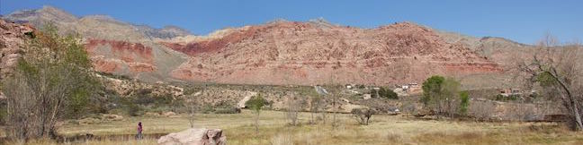
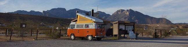
Red Rock Canyon National Conservation Area is a fantastic park to explore, with grand mountains and sandstone formations risings from the desert west of Las Vegas, Nevada. For those staying overnight in the park, Red Rock Canyon NCA has one campground with 72 sites. Like the rest of the park, the campground is managed by the Bureau of Land Management, which has established a well-developed campground for visitors. ...Read more.
By: Published: April 14, 2016 Last updated: April 12, 2026
Red Spring Boardwalk in Red Rock Canyon National Conservation Area
How significant is water in the desert? Head to Read Spring to find out, where a 0.55-mile boardwalk circles an out-of-place meadow fed by a small spring. Red Spring spills from the base of the Calico Hills beneath a ridge of wildly shaped sandstone. While most of the trails in Red Rock Canyon NCA begin along the Scenic Drive, Red Spring Boardwalk sets out from a picnic area off Calico Basin Road on the east side of the park closest to Las Vegas. ...Read more.
Distance: 0.55 miles · Elevation change: 50 feet
By: Published: April 14, 2016 Last updated: December 5, 2025
Lower Macleay Trail to Stone House (Witch’s Castle) in Forest Park, Portland
Do you like to hike but suffer from a little bit of fomo (fear of missing out)? Make your way to Northwest Portland for an outing in Forest Park that has a bit of everything. Start up Lower Macleay Trail along Balch Creek, the park's biggest year-round stream. Hike less than a mile through a verdant rainforest to arrive at Stone House (imaginatively nicknamed the Witch's Castle), where the ruins of an old building are alluringly grown over with moss and ferns. ...Read more.
Distance: 2 miles · Elevation change: 400 feet
By: Published: April 12, 2016 Last updated: April 9, 2026
Lower Macleay Park to Pittock Mansion in Forest Park, Portland
Hike a couple miles through the temperate rainforest in Forest Park and you could easily forget how close you are to downtown Portland. Jog your memory by hiking up to Pittock Mansion for a major view over the city. This 5.4-mile hike with 850 feet of elevation change starts from Lower Macleay Park in Northwest Portland. Stroll along Balch Creek on Lower Macleay Trail to Stone House and examine captivating ruins that make a fine destination on their own. ...Read more.
Distance: 5.4 miles · Elevation change: 850 feet
By: Published: April 12, 2016 Last updated: April 10, 2026
Mountain View Trail and Summit Lane in Powell Butte Nature Park
Are you in Portland, Oregon? Is it a clear day? If you answered yes to these questions, start making your way to Powell Butte. Located on the southeast side of the city, the butte is kept green by a 612-acre municipal park that offers several hiking trails for visitors. A short walk up a paved trail from the visitor center leads to the butte's 630-foot summit, which can offer salivating views of Mount Saint Helens, Mount Hood, and other peaks. ...Read more.
Distance: 2.15 miles · Elevation change: 165 feet
By: Published: April 9, 2016 Last updated: December 5, 2025
White Domes Trail in Valley of Fire State Park
White Domes Trail crosses stunning landscapes that reinvent themselves around every turn. The views on this 1.1-mile loop with 150 feet of elevation change are both varied and extraordinary. The circuit passes sandstone formations with different shapes and colors. The trail also visits an old film set and lets hikers slip through a narrow canyon. The surroundings are diverse and the hike is thrilling, making White Domes Trail one of the best places to experience Valley of Fire State Park's awesome beauty. ...Read more.
Tagged with · Arches · Nevada State Parks · Overton
Distance: 1.1 miles · Elevation change: 150 feet
By: Published: April 7, 2016 Last updated: December 5, 2025
Fire Wave Trail in Valley of Fire State Park
Stripes are something you don't see too often in nature (unless you live near a bunch of zebras), and the stripes at Fire Wave really stand out. In this isolated area of Valley of Fire State Park in Nevada, the slickrock has interchanging streaks of beige and red-orange colored sandstone. Fire Wave has a bowl-shaped depression with a couple rising points covered with wavy lines. ...Read more.
Tagged with · Nevada State Parks · Overton
Distance: 1.5 miles · Elevation change: 175 feet
By: Published: April 5, 2016 Last updated: December 5, 2025
Rainbow Vista in Valley of Fire State Park
You have to use some pretty colorful language when describing Rainbow Vista Trail, like vibrant, fiery, and effing extraordinary. The good news about Rainbow Vista Trail is that you get big views right from the start and any hiking you do will be picturesque. The bad news is that Rainbow Vista Trail is not as well marked as it could be and crosses sandy terrain with lots of spurious footpaths. ...Read more.
Tagged with · Nevada State Parks · Overton
Distance: 1.5 miles · Elevation change: 150 feet
By: Published: April 4, 2016 Last updated: December 5, 2025
Petroglyph Canyon Trail to Mouse’s Tank in Valley of Fire State Park
The best outing for seeing petroglyphs in Valley of Fire State Park is Petroglyph Canyon Trail. This 0.75-mile round trip hike passes rock faces that are covered in Native American rock art. The abundance of prehistoric petroglyphs on this trail is amazing. To cap things off, the trail ends at Mouse's Tank, a natural basin (or tinaja) of water suspended in sandstone. ...Read more.
Distance: 0.75 miles · Elevation change: 25 feet
By: Published: April 1, 2016 Last updated: December 5, 2025
Scenic Roads in Valley of Fire State Park
Every road through Valley of Fire State Park is scenic. The biggest wows come on White Domes Road, an official state and national scenic byway. The main road through the park, Valley of Fire Highway, is honored for its surrounding beauty as well. Scenic Loop Road branches off Valley of Fire Highway and can be used to bike or drive a 3-mile circuit past numerous natural attractions. ...Read more.
Tagged with · Arches · Nevada State Parks · Overton
By: Published: March 31, 2016 Last updated: April 8, 2026