Trail of two forests hike Washington lava forest tunnel Mount Saint Helens National Volcanic Monument Washington Gifford Pinchot National Forest
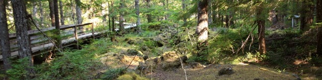
Trail of Two Forests offers a window into two time periods of forestation shaped by nearby Mount Saint Helens. The current forest is obvious - moss, fern, trees, and fighting shrubs that have regrown over lava that covered this land approximately 2,000 years ago. The second forest is ghosts of trees that once stood here. As slow-moving molten lava cooled, it surrounded trees and began to harden. ...Read more.
My Hikes: Completed hikeA green icon of shows a picture of a landscape with a check mark in the upper right corner, signifying that this is a hike you would like to put on your completed list.OK! Add to trails I've hiked
My Hikes: Want to hikeA green icon of shows a picture of a landscape with a heart in the upper right corner, signifying that this is a hike you would like to put on your to-do list.OK! Add to trails I want to hike
TagsA green icon depicting a tags represents a list of words and phrases that this content is tagged with Tagged with · Cascade Range · Gifford Pinchot National Forest · Lava · Lava Tubes · Nature Trails · Tree Molds
Hike DistanceA green icon of a hiker used to label information about the length of the hike Distance: 0.25 miles · Elevation change: 25 feet
By: Published: Last updated: September 2, 2025
Wahclella Falls Trail Waterfall hike Portland Oregon Columbia River Gorge Tanner Creek
If you were designing a landscape just for waterfalls, you would end up with something not unlike the Columbia River Gorge. Dozens of waterfalls spill from the basalt cliffs in this region. The abundance of water creates mossy natural retreats that could barely be matched even if you were designing a landscape from scratch. Multnomah Falls is the tallest waterfall in the area, and while Wahclella Falls is not as grand (its two tiers total 130 feet), it is quite charming and the trail to the waterfall is a lot less crowded. ...Read more.
My Hikes: Completed hikeA green icon of shows a picture of a landscape with a check mark in the upper right corner, signifying that this is a hike you would like to put on your completed list.OK! Add to trails I've hiked
My Hikes: Want to hikeA green icon of shows a picture of a landscape with a heart in the upper right corner, signifying that this is a hike you would like to put on your to-do list.OK! Add to trails I want to hike
TagsA green icon depicting a tags represents a list of words and phrases that this content is tagged with Tagged with · Cascade Range · Columbia River Gorge National Scenic Area · Free Trails · Waterfalls
Hike DistanceA green icon of a hiker used to label information about the length of the hike Distance: 2 miles · Elevation change: 250 feet
By: Published: Last updated: July 24, 2025
Multnomah Falls Trail Waterfall hike Portland Oregon Columbia River Gorge
Multnomah Falls is the tallest waterfall in Oregon and one of the tallest year-round waterfalls in the United States. The 620-foot waterfall is grand, beautiful, and easy to reach, making it one of the most popular outdoor attractions in the Pacific Northwest. Located in the Columbia River Gorge on the Washington - Oregon border, 30 miles east of Portland, Multnomah Falls offers something for hikers of all abilities. ...Read more.
My Hikes: Completed hikeA green icon of shows a picture of a landscape with a check mark in the upper right corner, signifying that this is a hike you would like to put on your completed list.OK! Add to trails I've hiked
My Hikes: Want to hikeA green icon of shows a picture of a landscape with a heart in the upper right corner, signifying that this is a hike you would like to put on your to-do list.OK! Add to trails I want to hike
TagsA green icon depicting a tags represents a list of words and phrases that this content is tagged with Tagged with · Cascade Range · Columbia River Gorge National Scenic Area · Free Trails · Waterfalls
Hike DistanceA green icon of a hiker used to label information about the length of the hike Distance: 0.4 miles · Elevation change: 25 feet
By: Published: Last updated: May 13, 2025
Watchman Trail Zion National Park hike
The closest trail to the south entrance of Zion Nation Park, and one of the best introductions to Zion, is Watchman Trail. This 3.5-mile lollipop loop climbs 500 feet to a rocky bench on the east side of Zion Canyon. The destination serves up stunning views of a nearby tower named The Watchman and several standout rock formations on the walls of Zion Canyon. ...Read more.
My Hikes: Completed hikeA green icon of shows a picture of a landscape with a check mark in the upper right corner, signifying that this is a hike you would like to put on your completed list.OK! Add to trails I've hiked
My Hikes: Want to hikeA green icon of shows a picture of a landscape with a heart in the upper right corner, signifying that this is a hike you would like to put on your to-do list.OK! Add to trails I want to hike
TagsA green icon depicting a tags represents a list of words and phrases that this content is tagged with Tagged with · Desert Canyons · National Parks · Zion Canyon
Hike DistanceA green icon of a hiker used to label information about the length of the hike Distance: 3.5 miles · Elevation change: 500 feet
By: Published: Last updated: December 31, 2017
Canyon Overlook Trail Zion National Park hike
Rarely is a mile-long hike as action packed and rewarding as Canyon Overlook Trail. The overlook sits on the rim of Pine Creek Canyon, which adjoins Zion Canyon to provide massive views of thousand-foot tall sandstone bluffs. There are ravines and overhangs along the short trail that will keep you entertained along the way. This excellent hike is appealing to all, especially those with limited time in Zion National Park. ...Read more.
My Hikes: Completed hikeA green icon of shows a picture of a landscape with a check mark in the upper right corner, signifying that this is a hike you would like to put on your completed list.OK! Add to trails I've hiked
My Hikes: Want to hikeA green icon of shows a picture of a landscape with a heart in the upper right corner, signifying that this is a hike you would like to put on your to-do list.OK! Add to trails I want to hike
TagsA green icon depicting a tags represents a list of words and phrases that this content is tagged with Tagged with · Desert Canyons · National Parks · Zion Canyon
Hike DistanceA green icon of a hiker used to label information about the length of the hike Distance: 1 mile · Elevation change: 150 feet
By: Published: Last updated: December 31, 2017
Riverside Walk Zion National Park trail river narrows hike
Riverside Walk accesses the notorious narrows north of Zion Canyon, making it one of the most popular trails in Zion National Park. To the end of the trail (at the start of the narrows) and back is a 1.8-mile hike over a level walkway bordering the Virgin River. Those looking to escape the Utah summer heat can leave the trail at any of several river access points to take a refreshing swim. ...Read more.
My Hikes: Completed hikeA green icon of shows a picture of a landscape with a check mark in the upper right corner, signifying that this is a hike you would like to put on your completed list.OK! Add to trails I've hiked
My Hikes: Want to hikeA green icon of shows a picture of a landscape with a heart in the upper right corner, signifying that this is a hike you would like to put on your to-do list.OK! Add to trails I want to hike
TagsA green icon depicting a tags represents a list of words and phrases that this content is tagged with Tagged with · Creeks · Desert Canyons · National Parks · Zion Canyon
Hike DistanceA green icon of a hiker used to label information about the length of the hike Distance: 1.8 miles · Elevation change: 60 feet
By: Published: Last updated: December 31, 2017
Devils Kitchen Trail is located near the south end of Colorado National Monument at the bottom of rugged No Thoroughfare Canyon. This 1.2-mile hike ascends 225 feet to visits an intriguing rock formation on the side of the canyon where tall boulders have enclosed a rock grotto
Devils Kitchen Trail is located near the south end of Colorado National Monument at the bottom of rugged No Thoroughfare Canyon. This 1.2-mile hike ascends 225 feet to visits an intriguing rock formation on the side of the canyon where tall boulders have enclosed a rock grotto. No Thoroughfare Canyon Two junctions are along the way and the path gets faint toward the end, so follow the directions on this one. ...Read more.
My Hikes: Completed hikeA green icon of shows a picture of a landscape with a check mark in the upper right corner, signifying that this is a hike you would like to put on your completed list.OK! Add to trails I've hiked
My Hikes: Want to hikeA green icon of shows a picture of a landscape with a heart in the upper right corner, signifying that this is a hike you would like to put on your to-do list.OK! Add to trails I want to hike
TagsA green icon depicting a tags represents a list of words and phrases that this content is tagged with Tagged with · Desert Canyons · Fruita · Grand Junction
Hike DistanceA green icon of a hiker used to label information about the length of the hike Distance: 1.2 miles · Elevation change: 225 feet
By: Published: Last updated: June 3, 2017
Monument Canyon Trail to Independence Monument in Colorado National Monument near Grand Junction Colorado
Monument Canyon Trail is six miles long in one direction, dropping from Rim Rock Drive across Monument Canyon to a second trailhead on the eastern edge of the park. Three and a half miles (and 850 vertical feet) from the top, the trail passes Independence Monument, the largest freestanding rock formation in the park. A popular hike along Monument Canyon Trail is a 7-mile out and back from Rim Rock Drive to Independence Monument. ...Read more.
My Hikes: Completed hikeA green icon of shows a picture of a landscape with a check mark in the upper right corner, signifying that this is a hike you would like to put on your completed list.OK! Add to trails I've hiked
My Hikes: Want to hikeA green icon of shows a picture of a landscape with a heart in the upper right corner, signifying that this is a hike you would like to put on your to-do list.OK! Add to trails I want to hike
TagsA green icon depicting a tags represents a list of words and phrases that this content is tagged with Tagged with · Desert Canyons · Fruita · Grand Junction
Hike DistanceA green icon of a hiker used to label information about the length of the hike Distance: 7 miles · Elevation change: 850 feet
By: Published: Last updated: June 3, 2017
Coke Ovens Trail hike Colorado National Monument Canyon
Coke Oven's Trail shares a trailhead with Monument Canyon Trail and the collection of rock domes can be visited as their own destination or as a side attraction on a longer trek into Monument Canyon. The hike to Coke Ovens is one-mile round trip with 180 feet of elevation loss. From the turnout along Rim Rock Drive, begin hiking east into the canyon. ...Read more.
My Hikes: Completed hikeA green icon of shows a picture of a landscape with a check mark in the upper right corner, signifying that this is a hike you would like to put on your completed list.OK! Add to trails I've hiked
My Hikes: Want to hikeA green icon of shows a picture of a landscape with a heart in the upper right corner, signifying that this is a hike you would like to put on your to-do list.OK! Add to trails I want to hike
TagsA green icon depicting a tags represents a list of words and phrases that this content is tagged with Tagged with · Desert Canyons · Fruita · Grand Junction
Hike DistanceA green icon of a hiker used to label information about the length of the hike Distance: 1 mile · Elevation change: 180 feet
By: Published: Last updated: June 4, 2017
Otto's Trail Colorado National Monument Ottos Trail Hike
Otto's Trail is one of the shorter hikes along Rim Rock Drive in Colorado National Monument. Like Window Rock Trail, this 0.75-mile stroll descends gradually to a cliff overlooking Monument Canyon. The view showcases Independence Monument, the tallest freestanding formation in the canyon, and a point of fascination for visitors dating back to the first park supervisor, John Otto, for whom this trail is named. ...Read more.
My Hikes: Completed hikeA green icon of shows a picture of a landscape with a check mark in the upper right corner, signifying that this is a hike you would like to put on your completed list.OK! Add to trails I've hiked
My Hikes: Want to hikeA green icon of shows a picture of a landscape with a heart in the upper right corner, signifying that this is a hike you would like to put on your to-do list.OK! Add to trails I want to hike
TagsA green icon depicting a tags represents a list of words and phrases that this content is tagged with Tagged with · Desert Canyons · Fruita · Grand Junction
Hike DistanceA green icon of a hiker used to label information about the length of the hike Distance: 0.75 miles · Elevation change: 85 feet
By: Published: Last updated: June 4, 2017