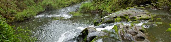
Beaver Falls in Clatskanie, Oregon
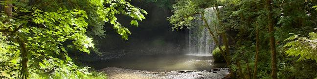
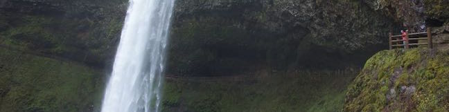
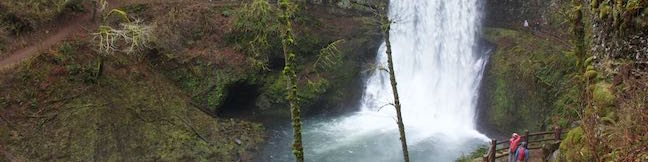
Just off Route 30 between Portland and Astoria, travelers can gush over a short hike to a lovely waterfall. Beaver Falls (a.k.a. Beaver Creek Falls) takes a single-drop plunge off a basalt ledge. The waterfall is nearly 50 feet tall and swells to 40 feet wide. This quick delight of a hike descends 100 feet through forest for a 0.7-mile round trip outing. ...Read more.
Tagged with · Clatskanie · Free Trails · Waterfalls
Distance: 0.7 miles · Elevation change: 100 feet
By: Published: December 19, 2017 Last updated: December 5, 2025
Round Lake Loop & Pothole Falls in Lacamas Lake Regional Park
Potholes aren't always bad. The creatively carved-out bedrock at Pothole Falls adds to the allure of the cascades. Pothole Falls is just a stone's throw from Round Lake, a 26-acre body in Lacamas Lake Regional Park in Camas, Washington. Round Lake Loop Trail offers a relaxing nature trail through lake-edge forest. Circle Round Lake and check out Pothole Falls on a 1. ...Read more.
Distance: 1.6 miles · Elevation change: 200 feet
By: Published: December 14, 2017 Last updated: April 9, 2026
Dog Mountain in Columbia River Gorge National Scenic Area
It isn't pack mentality that makes Dog Mountain one of the most popular hikes on the Washington side of the Columbia River Gorge. The grassy slopes near the summit put on a winning display of spring wildflowers, enhancing year-round views over the gorge's beautiful surroundings. Dog Mountain Trail is steep and largely forested, ascending 2,825 feet in 3 1/3 miles. ...Read more.
Distance: 7.4 miles · Elevation change: 2825 feet
By: Published: September 2, 2017 Last updated: April 18, 2026
Coyote Wall in Columbia River Gorge National Scenic Area
Take a drive through the Columbia River Gorge and you're sure to be impressed by a diagonal band of cliffs on the Washington side of the gorge that rise from the river toward the mountains above. These grand and daunting cliffs are called Coyote Wall or the Syncline. A network of single-track trails and old jeep roads extend up alongside the columnar basalt ledge. ...Read more.
Distance: 5.8 miles · Elevation change: 1575 feet
By: Published: July 28, 2017 Last updated: April 18, 2026
Reservoir Canyon Trail – Summit Trail Loop in Reservoir Canyon Natural Reserve
If you've hiked up the hill east of downtown San Luis Obispo on Reservoir Canyon Trail or Summit Trail, you've probably pondered the prospect of connecting the two hikes in order to spend more time enjoying grand views over San Luis Obispo County. Follow Reservoir Canyon Trail up to a stone bench viewpoint, cross Ridge Trail to an old tower housing a bell, and descend Summit Trail to complete a 5. ...Read more.
Distance: 5.6 miles · Elevation change: 1350 feet
By: Published: July 13, 2017 Last updated: December 5, 2025
Summit Trail in Reservoir Canyon Natural Reserve
You'll give a ringing endorsement to this San Luis Obispo hike! Reservoir Canyon's Summit Trail ascends to sweeping panoramas over San Luis Obispo and an old tower with a bell that you can ring with a pebble. The hike from Reservoir Canyon to the High School Hill Tower is 4.1 miles round trip with 1,175 feet of elevation change. Expand your horizons from there by following Ridge Trail up to the high point of Murray Hill and descend Reservoir Canyon Trail on the 5. ...Read more.
Distance: 4.1 miles · Elevation change: 1175 feet
By: Published: July 12, 2017 Last updated: April 8, 2026
South Falls in Silver Falls State Park
South Falls is the tallest waterfall in Silver Falls State Park, dropping a spectacular 177 feet off a basalt shelf. South Falls can be visited (along with nine other waterfalls) on the park's great loop, the Trail of Ten Falls. When this 7.9-mile loop is too much, a 1.1-mile lollipop loop can be hiked to visit South Falls on its own. The short hike has 200 feet of elevation change. ...Read more.
Distance: 1.1 miles · Elevation change: 200 feet
By: Published: July 10, 2017 Last updated: April 18, 2026
Hamilton Mountain Loop in Beacon Rock State Park
Only hike Hamilton Mountain Trail if you like charming forests, bold waterfalls, and awesome cliff-top views. Hamilton Mountain Trail passes a viewpoint for the Pool of the Winds, where Rodney Falls plunges into a rock-wrapped punchbowl. The trail rises to a summit along the Columbia River Gorge, ascending 2,025 feet on a 7.75-mile lollipop loop. Some of Hamilton Mountain's best views come from a perch below the summit and a saddle after the summit. ...Read more.
Distance: 7.75 miles · Elevation change: 2025 feet
By: Published: July 9, 2017 Last updated: April 25, 2026
Beacon Rock Trail in Beacon Rock State Park
Beacon Rock rises like a stone tower with sheer cliffs dropping to the Columbia River. Beacon Rock Trail could be the Columbia River Gorge relative of Moro Rock Trail in Sequoia National Park. The trail is built right up the side of the basalt monolith, using over fifty switchbacks and at least a dozen cliff-straddling bridges to reach a pointed summit. ...Read more.
Distance: 1.6 miles · Elevation change: 600 feet
By: Published: June 24, 2017 Last updated: April 25, 2026
Trail of Ten Falls in Silver Falls State Park
Silver Falls State Park has one of the most incredible waterfall hikes to be found in Oregon or anywhere else in North America. Trail of Ten Falls takes a tour of Silver Creek Canyon, passing ten beautiful waterfalls and a high number of cascades and other waterfalls that pop up in winter and spring. The 7.9-mile loop was built to deliver plenty of excitement along the way and actually takes hikers behind four of the waterfalls as they pour over basalt cliffs. ...Read more.
Distance: 7.9 miles · Elevation change: 600 feet
By: Published: June 22, 2017 Last updated: December 5, 2025