Riverside Walk Zion National Park trail river narrows hike
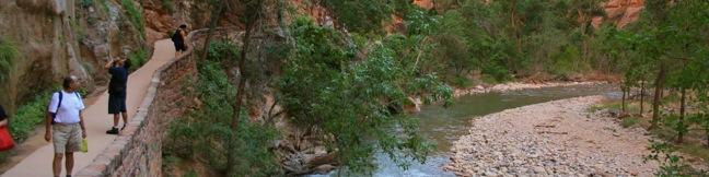
Riverside Walk accesses the notorious narrows north of Zion Canyon, making it one of the most popular trails in Zion National Park. To the end of the trail (at the start of the narrows) and back is a 1.8-mile hike over a level walkway bordering the Virgin River. Those looking to escape the Utah summer heat can leave the trail at any of several river access points to take a refreshing swim. ... Read more.
OK! Add to trails I’ve hiked
OK! Add to trails I want to hike
Tagged with · Creeks · Desert Canyons · National Parks · Zion Canyon
Distance: 1.8 miles · Elevation change: 60 feet
By: Published: Last updated: December 31, 2017
Froom Creek Trail Irish Hills San Luis Obispo hike Froom Canyon
On the east side of the Irish Hills, there is a canyon with a surprisingly southwestern feel. Though surrounded by traditional coastal chaparral, the trail follows an old road up a canyon akin to the old mining roads converted into hiking trails found in the California desert. Above the canyon, there are broad views of San Luis Obispo's most prominent Morros, Bishop Peak and Cerro San Luis. ... Read more.
OK! Add to trails I’ve hiked
OK! Add to trails I want to hike
Tagged with · Free Trails · Irish Hills
Distance: 3 miles · Elevation change: 500 feet
By: Published: Last updated: April 2, 2019
Morro View Irish Hills hike San Luis Obispo Mariposa Trail Prefumo Canyon Irish Hills Natural Reserve hiking SLO
An expansive network of trails explore the thousand-foot ridges that make up the Irish Hills southwest of San Luis Obispo. While the regions notable chain of volcanic peaks gather greater attention from hikers, you can actually get a great view of the Morros from the Irish Hills, with smaller crowds. From Prefumo Canyon, one of the two main trailheads in the Irish Hills Natural Reserve,... Read more.
OK! Add to trails I’ve hiked
OK! Add to trails I want to hike
Tagged with · Free Trails · Irish Hills
Distance: 3.15 miles · Elevation change: 850 feet
By: Published: Last updated: April 2, 2019
Reservoir Canyon Trail summit hike Reservoir Creek Falls San Luis Obispo California Reservoir Canyon Natural Reserve hiking Murray Hill
From a less heralded summit in the Santa Lucia Foothills northeast of San Luis Obispo, you will find triumphant views of the peaks and valleys surrounding this gem on the Central Coast. The hike from Reservoir Canyon to this 1,715-foot crown is not for the meek. The 5.35-mile round trip hike ascends 1,350 feet, and over 800 of those feet come in the final grueling mile. The effort is... Read more.
OK! Add to trails I’ve hiked
OK! Add to trails I want to hike
Tagged with · Creeks · Free Trails · Reservoir Canyon Natural Reserve · Summits · Waterfalls
Distance: 5.35 miles · Elevation change: 1350 feet
By: Published: Last updated: February 13, 2019
Knapps Castle Trail Santa Barbara ruins Camino Cielo hike
In the mountains above Santa Barbara, a plot of privately owned land surrounded by the Los Padres National Forest. On that land stand the remains of a palatial estate that burned down seventy years ago, the so-called Knapp's Castle. To the ruins and back is a 0.8-mile round trip hike with 50 feet of elevation change. The majestic views from this unique spot far exceed the effort. From... Read more.
OK! Add to trails I’ve hiked
OK! Add to trails I want to hike
Tagged with · Los Padres National Forest · Ruins · Santa Ynez Mountains
Distance: 0.8 miles · Elevation change: 50 feet
By: Published: Last updated: January 17, 2018
Gaviota Hot Springs Trail Los Padres Santa Barbara hike Gaviota State Park spring
Driving up Highway 101 through the Gaviota Tunnel west of Santa Barbara, you might be unaware that a natural hot springs is less than a mile from the roadway. Gaviota Hot Springs is more warm than it is hot, but the blue sulfery water attracts its share of bathers. The springs are half a mile from the trailhead and only a tenth of a mile off the trail to Gaviota Peak, making it a nice... Read more.
OK! Add to trails I’ve hiked
OK! Add to trails I want to hike
Tagged with · California State Parks · Gaviota State Park · Goleta · Hot Springs · Santa Ynez Mountains
Distance: 1 mile · Elevation change: 400 feet
By: Published: Last updated: May 22, 2017
Hetch Hetchy Reservoir hike Wapama Falls Rancharia Tueeulala Waterfall Kolana Rock Yosemite National Park Trail
In the northwest corner of Yosemite National Park is a valley that John Muir described as “a wonderfully exact counterpart of the great Yosemite.” Since Muir's time, Hetch Hetchy Valley has changed. It was dammed in 1923 and a large blue reservoir now covers the valley. Muir opposed the dam, and fellow conservationists lost a long battle to preserve the valley. An effort... Read more.
OK! Add to trails I’ve hiked
OK! Add to trails I want to hike
Tagged with · Backpacking · Lakes · National Parks · Waterfalls
Distance: 5 miles · Elevation change: 200 feet
By: Published: Last updated: January 30, 2018
May Lake hike Yosemite National Park Trail
May Lake is a high elevation lake off Tioga Road in Yosemite National Park north of Yosemite Valley. This 2.4-mile hike with 475 feet of elevation gain is a perfect outing for summer and early fall when the road and trail are free of snow. Stroll along a wide trail through a lovely pine forest. As you near the lake, gradually ascend a granite floor with sparser tree cover. When you... Read more.
OK! Remove from my hikes
OK! Add to trails I want to hike
Tagged with · Lakes · National Parks
Distance: 2.4 miles · Elevation change: 475 feet
By: Published: Last updated: August 14, 2021
Half Dome hike Yosemite National Park John Muir Trail Half Dome Trail
It might be half a dome, but it's a full day's hike - 16 miles round trip from Yosemite Valley with 4,800 feet of elevation gain. Is Yosemite's much heralded bucket-list hike worth all the hoopla? You bet it is. Half Dome is an iconic element of the Yosemite landscape and the trail to its summit is a one of a kind. The hike up Half Dome is a major challenge (and a major reward). ... Read more.
OK! Add to trails I’ve hiked
OK! Add to trails I want to hike
Tagged with · Backpacking · John Muir Trail · National Parks · Summits · Waterfalls · Yosemite Valley
Distance: 16 miles · Elevation change: 4800 feet
By: Published: Last updated: September 9, 2019
Mist Trail Vernal Fall hike Yosemite National Park Nevada Falls John Muir Trail Loop
On the path to Half Dome, Yosemite's most imposing bucket list hike, are two impressive waterfalls coursing down the Merced River. The Mist Trail provides the steepest most intimate experience of Vernal Fall and Nevada Fall. John Muir Trail takes a more gradual route to the top of Nevada Fall and is the most practical route for those continuing to Half Dome. Day hikes on the Mist Trail... Read more.
OK! Add to trails I’ve hiked
OK! Add to trails I want to hike
Tagged with · John Muir Trail · National Parks · Waterfalls · Yosemite Valley
Distance: 6.1 miles · Elevation change: 1925 feet
By: Published: Last updated: April 8, 2023