Coal Mines Historic Site Convict Precinct Walk Tasman Peninsula Tasmania Australia Hike Penal Colony Tour
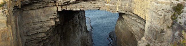
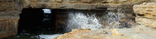
If you think being a prisoner at a Tasmanian penal colony sounds bad, add coal mining to that prison sentence and you get something truly awful. Such was the case in the 1830s and 40s when, just after the famous Port Arthur Penal Colony was established, convict laborers were sent to another part of the Tasman Peninsula to work in coal mines (and you can imagine that working conditions in the... Read more.
My Hikes: Completed hikeA green icon of shows a picture of a landscape with a check mark in the upper right corner, signifying that this is a hike you would like to put on your completed list.OK! Add to trails I've hiked
My Hikes: Want to hikeA green icon of shows a picture of a landscape with a heart in the upper right corner, signifying that this is a hike you would like to put on your to-do list.OK! Add to trails I want to hike
TagsA green icon depicting a tags represents a list of words and phrases that this content is tagged with Tagged with · Mines · Ocean Views · Ruins · Saltwater River · Tasman Peninsula
Hike DistanceA green icon of a hiker used to label information about the length of the hike Distance: 0.8 kilometers / 0.5 miles · Elevation change: 10 meters / 30 feet
By: Published: Last updated: May 6, 2017
Cape Raoul Track Tasman Peninsula Bushwalk Tasman National Park Stormlea Tasmania Cape Raoul Cliffs Walk
With some of the tallest sea cliffs in Australia, Cape Raoul is a daunting promontory jutting south from the Tasman Peninsula. While it is listed as one of Tasmania's 60 Great Short Walks, this hike is longer and harder than other tracks on that list at 12 to 14 kilometers (7.45 to 8.7 miles) round trip. The out and back bushwalk follows a track through wild vegetation in Tasman National... Read more.
My Hikes: Completed hikeA green icon of shows a picture of a landscape with a check mark in the upper right corner, signifying that this is a hike you would like to put on your completed list.OK! Add to trails I've hiked
My Hikes: Want to hikeA green icon of shows a picture of a landscape with a heart in the upper right corner, signifying that this is a hike you would like to put on your to-do list.OK! Add to trails I want to hike
TagsA green icon depicting a tags represents a list of words and phrases that this content is tagged with Tagged with · Ocean Views · Tasman National Park · Tasman Peninsula · Tasmania's 60 Great Short Walks
Hike DistanceA green icon of a hiker used to label information about the length of the hike Distance: 14 kilometers / 8.7 miles · Elevation change: 240 meters / 790 feet
By: Published: Last updated: May 19, 2024
Tasmans Arch Devils Kitchen Lookout Tasman Peninsula Walk Tasman National Park Eaglehawk Neck Devil's Kitchen Tasman's Arch Sea Cliffs
The Tasman Peninsula extends into the Tasman Sea in the southeast corner of Tasmania. While the peninsula was once used as a penitentiary, a visit to the peninsula's impressive coastline today will feel like anything but prison. Just south of the narrow isthmus at Eaglehawk Neck, the east coast of the peninsula has several easy-to-reach wonders, including Tasmans Arch and Devils Kitchen (as... Read more.
My Hikes: Completed hikeA green icon of shows a picture of a landscape with a check mark in the upper right corner, signifying that this is a hike you would like to put on your completed list.OK! Add to trails I've hiked
My Hikes: Want to hikeA green icon of shows a picture of a landscape with a heart in the upper right corner, signifying that this is a hike you would like to put on your to-do list.OK! Add to trails I want to hike
TagsA green icon depicting a tags represents a list of words and phrases that this content is tagged with Tagged with · Australian National Parks · Eaglehawk Neck · Natural Bridges · Ocean Views · Tasman National Park · Tasman Peninsula
Hike DistanceA green icon of a hiker used to label information about the length of the hike Distance: 0.9 kilometers / 0.55 miles · Elevation change: 5 meters / 15 feet
By: Published: Last updated: May 19, 2024
Tasman Blowhole Fossil Bay Lookout Tasman Peninsula Tasman National Park The Blowhole Eaglehawk Neck Doo Town Fossil Bay Walk
The Tasman Peninsula extends into the Tasman Sea in the southeast corner of Tasmania. While the peninsula was once used as a penitentiary, a visit to the peninsula's impressive coastline today will feel like anything but prison. Just south of the narrow isthmus at Eaglehawk Neck, the east coast of the peninsula has several easy-to-reach wonders, including the Blowhole and Fossil Bay Lookout... Read more.
My Hikes: Completed hikeA green icon of shows a picture of a landscape with a check mark in the upper right corner, signifying that this is a hike you would like to put on your completed list.OK! Add to trails I've hiked
My Hikes: Want to hikeA green icon of shows a picture of a landscape with a heart in the upper right corner, signifying that this is a hike you would like to put on your to-do list.OK! Add to trails I want to hike
TagsA green icon depicting a tags represents a list of words and phrases that this content is tagged with Tagged with · Australian National Parks · Blowholes · Eaglehawk Neck · Ocean Views · Tasman National Park · Tasman Peninsula
Hike DistanceA green icon of a hiker used to label information about the length of the hike Distance: 0.45 kilometers / 0.3 miles · Elevation change: 10 meters / 30 feet
By: Published: Last updated: May 19, 2024
Camping Lime Bay State Reserve Campground Tasmania Australia Lime Bay Campsites Tasman Peninsula
If you're on the lookout for a campground on the Tasmanian coast with grassy plots shaded by eucalyptus trees, don't overlook Lime Bay State Reserve. This off-the-beaten-path campground is located on a remote thumb of the Tasman Peninsula, set in a picturesque bay with light sand beaches framing the campground on both sides. Lime Bay State Reserve Campground Lime Bay State Reserve... Read more.
TagsA green icon depicting a tags represents a list of words and phrases that this content is tagged with Tagged with · Beaches · Campervan Camping · Ocean Views · Saltwater River · Tasman Peninsula · Tent Camping
By: Published: Last updated: May 19, 2024
Hazards Beach Wineglass Bay Circuit Freycinet National Park Wineglass Bay Track Loop Tasmania Australia Freycinet Peninsula Hazards Beach Track Wineglass Bay Lookout Hike
Wineglass Bay is one of the top-rate beaches in Australia, and a premier destination for hikers in Freycinet National Park. A great way to see Wineglass Bay and the beautiful beach on the opposite side of the peninsula is to hike Wineglass Bay and Hazards Beach Circuit. This loop loop is 11.5 kilometers (7.15 miles) long, or a bit farther if you walk out along the beach at Wineglass Bay and... Read more.
My Hikes: Completed hikeA green icon of shows a picture of a landscape with a check mark in the upper right corner, signifying that this is a hike you would like to put on your completed list.OK! Add to trails I've hiked
My Hikes: Want to hikeA green icon of shows a picture of a landscape with a heart in the upper right corner, signifying that this is a hike you would like to put on your to-do list.OK! Add to trails I want to hike
TagsA green icon depicting a tags represents a list of words and phrases that this content is tagged with Tagged with · Australian National Parks · Beaches · Coles Bay · Freycinet National Park · Freycinet Peninsula · Ocean Views
Hike DistanceA green icon of a hiker used to label information about the length of the hike Distance: 12 kilometers / 7.45 miles · Elevation change: 213 meters / 700 feet
By: Published: Last updated: May 19, 2024
Richardsons Beach Campground Freycinet National Park Coles Bay camping Freycinet Peninsula Tasmania Australia
Freycinet National Park's main campground is popular for a reason. Its campsites are spaced out behind an inviting sandy beach in a bay at the top of Freycinet Peninsula's sheltered west coast. Richardsons Beach Campground boast fine bay views and is close to the town of Coles Bay and walking tracks in Freycinet National Park. With both powered and non-powered sites, Richardsons Beach... Read more.
TagsA green icon depicting a tags represents a list of words and phrases that this content is tagged with Tagged with · Australian National Parks · Beaches · Campervan Camping · Coles Bay · Freycinet National Park · Freycinet Peninsula · Ocean Views · Tent Camping
By: Published: Last updated: February 5, 2025
Cape Tourville Lighthouse Freycinet National Park Tasmania Australia Freycinet Peninsula Cape Tourville Track
Freycinet National Park preserves a picturesque peninsula on Tasmania's east coast. The park's beaches are the pride of Tasmania, and if you've got slightly loftier ambitions, and you can get a great overview of the peninsula from Cape Tourville. An easy 600-meter long trail loops around this promontory on the peninsula's east coast, crossing 100-meter tall granite bluffs to reach the Cape... Read more.
My Hikes: Completed hikeA green icon of shows a picture of a landscape with a check mark in the upper right corner, signifying that this is a hike you would like to put on your completed list.OK! Add to trails I've hiked
My Hikes: Want to hikeA green icon of shows a picture of a landscape with a heart in the upper right corner, signifying that this is a hike you would like to put on your to-do list.OK! Add to trails I want to hike
TagsA green icon depicting a tags represents a list of words and phrases that this content is tagged with Tagged with · Australian National Parks · Coles Bay · Freycinet National Park · Freycinet Peninsula · Lighthouses · Ocean Views · Tasmania's 60 Great Short Walks
Hike DistanceA green icon of a hiker used to label information about the length of the hike Distance: 0.65 kilometers / 0.4 miles · Elevation change: 30 meters / 100 feet
By: Published: Last updated: May 19, 2024
Friendly Beaches Campground Freycinet National Park Coles Bay Beach camping Tasmania Australia
Friendly Beaches Campground is a primitive campground in Freycinet National Park on Tasmania's east coast just north of the town of Coles Bay. While the campground lacks many comfortable features like picnic tables, fire rings, and running water (there is a toilet at least), the campground is located on an undeveloped coastline surrounded by light sand beaches, which makes it a very... Read more.
TagsA green icon depicting a tags represents a list of words and phrases that this content is tagged with Tagged with · Australian National Parks · Beaches · Coles Bay · Freycinet National Park · Freycinet Peninsula · Tent Camping
By: Published: Last updated: May 19, 2024
Friendly Beaches Freycinet National Park Coles Bay Beach Walk Tasmania Australia
Visit long stretches of light sand running along the pristine east coast of Tasmania north of the Freycinet Peninsula. The trail to Friendly Beaches is listed as one of Tasmania's 60 Great Short Walks, and it takes little effort to get from the car park to the beach. A 10-meter long boardwalk leads to an overlook behind the beach and another 10 meters of steps take you down to the sand. ... Read more.
My Hikes: Completed hikeA green icon of shows a picture of a landscape with a check mark in the upper right corner, signifying that this is a hike you would like to put on your completed list.OK! Add to trails I've hiked
My Hikes: Want to hikeA green icon of shows a picture of a landscape with a heart in the upper right corner, signifying that this is a hike you would like to put on your to-do list.OK! Add to trails I want to hike
TagsA green icon depicting a tags represents a list of words and phrases that this content is tagged with Tagged with · Australian National Parks · Beaches · Coles Bay · Freycinet National Park · Freycinet Peninsula · Ocean Views · Tasmania's 60 Great Short Walks
Hike DistanceA green icon of a hiker used to label information about the length of the hike Distance: 0.1 kilometers / 0.05 miles · Elevation change: 10 meters / 30 feet
By: Published: Last updated: May 19, 2024