Calabasas Peak hike Calabasas Peak Motorway Trail Santa Monica Mountains Trail
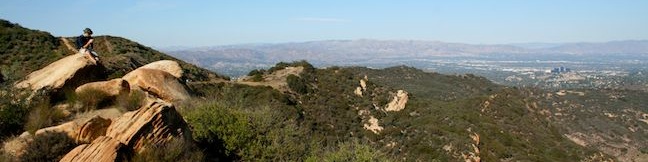
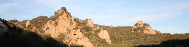
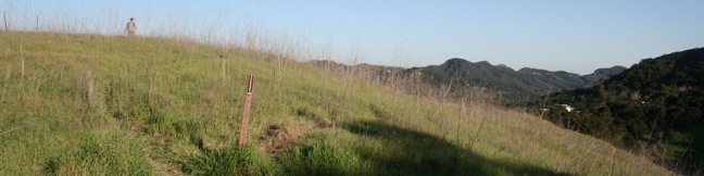
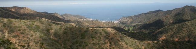
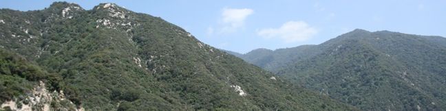
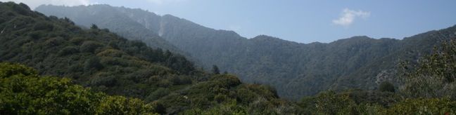
Calabasas Peak offers panoramic views of the Santa Monica Mountains, Red Rock Canyon Park, and a sliver of the Pacific Ocean. To the north, the peak looks down on the city of Calabasas and a wide stretch of the San Fernando Valley. The 3.6-mile round trip hike to Calabasas Peak travels an easy-to-follow fire road. There is 900 feet of elevation gain along the way, but that effort is rewarded by great views at every turn. ...Read more.
My Hikes: Completed hikeA green icon of shows a picture of a landscape with a check mark in the upper right corner, signifying that this is a hike you would like to put on your completed list.OK! Add to trails I've hiked
My Hikes: Want to hikeA green icon of shows a picture of a landscape with a heart in the upper right corner, signifying that this is a hike you would like to put on your to-do list.OK! Add to trails I want to hike
TagsA green icon depicting a tags represents a list of words and phrases that this content is tagged with Tagged with · Bouldering · Calabasas · Free Trails · Malibu · Off Trail · Summits · Dog-Friendly Trails · Mountain Biking Trails · Santa Monica Mountains
Hike DistanceA green icon of a hiker used to label information about the length of the hike Distance: 3.6 miles · Elevation change: 900 feet
By: Published: Last updated: December 7, 2018
Stunt High Trail to Saddle Peak Santa Monica Mountains Saddle Peak Hike Stunt High Road
Stunt High Trail begins with a gentle walk along Cold Creek, and then ascends through meadows and chaparral up the northern slope of Saddle Peak to offer great views of the Santa Monica Mountains. Stunt High Trail ends at a road, 2.17 miles from the start, which is a rather anti-climactic high point. From there, pick up the Backbone Trail and hike to the top of Saddle Peak, the sixth tallest summit in the range, where wide views over Malibu and the Pacific can be enjoyed. ...Read more.
My Hikes: Completed hikeA green icon of shows a picture of a landscape with a check mark in the upper right corner, signifying that this is a hike you would like to put on your completed list.OK! Add to trails I've hiked
My Hikes: Want to hikeA green icon of shows a picture of a landscape with a heart in the upper right corner, signifying that this is a hike you would like to put on your to-do list.OK! Add to trails I want to hike
TagsA green icon depicting a tags represents a list of words and phrases that this content is tagged with Tagged with · Backbone Trail · Free Trails · Malibu · Summits · Wildflowers · Dog-Friendly Trails · Santa Monica Mountains
Hike DistanceA green icon of a hiker used to label information about the length of the hike Distance: 8.2 miles · Elevation change: 1675 feet
By: Published: Last updated: May 13, 2025
Red Rock Canyon Park Malibu Agoura Hills Santa Monica Mountains Calabasas California hike
As the name implies, Red Rock Canyon is filled with impressive colorful sandstone. The red rocks stand out from their lush green surroundings to create a dramatic landscape. The canyon lies adjacent to Calabasas Peak, which can be visited in conjunction with the park to form an excellent excursion. The park's main entrance is located at the end of Red Rock Road. ...Read more.
My Hikes: Completed hikeA green icon of shows a picture of a landscape with a check mark in the upper right corner, signifying that this is a hike you would like to put on your completed list.OK! Add to trails I've hiked
My Hikes: Want to hikeA green icon of shows a picture of a landscape with a heart in the upper right corner, signifying that this is a hike you would like to put on your to-do list.OK! Add to trails I want to hike
TagsA green icon depicting a tags represents a list of words and phrases that this content is tagged with Tagged with · Bouldering · Calabasas · Mountains Recreation and Conservation Authority · Topanga · Topanga Canyon · Dog-Friendly Trails · Mountain Biking Trails · Santa Monica Mountains
Hike DistanceA green icon of a hiker used to label information about the length of the hike Distance: 2.5 miles · Elevation change: 325 feet
By: Published: Last updated: December 7, 2018
Icehouse Canyon Icehouse Saddle Hike Baldy View Angeles National Forest Cucamonga Wilderness Icehouse Canyon to Icehouse Saddle
Icehouse Canyon is located in a beautiful stretch of the Angeles National Forest near Mount Baldy Village, just southeast of the mighty Mount Baldy. A trail through the canyon leads up to Icehouse Saddle. At 7,500 feet, this low point in the ridgeline offers sweeping views of the western San Gabriel Mountains. From the saddle, hikers and backpackers may continue on in several directions to explore nearby peaks and venture deeper into the Cucamonga Wilderness. ...Read more.
My Hikes: Completed hikeA green icon of shows a picture of a landscape with a check mark in the upper right corner, signifying that this is a hike you would like to put on your completed list.OK! Add to trails I've hiked
My Hikes: Want to hikeA green icon of shows a picture of a landscape with a heart in the upper right corner, signifying that this is a hike you would like to put on your to-do list.OK! Add to trails I want to hike
TagsA green icon depicting a tags represents a list of words and phrases that this content is tagged with Tagged with · Adventure Pass · Angeles National Forest · Claremont · Cucamonga Wilderness · Dog-Friendly Trails · San Gabriel Mountains
Hike DistanceA green icon of a hiker used to label information about the length of the hike Distance: 7.2 miles · Elevation change: 2600 feet
By: Published: Last updated: June 5, 2017
Hondo Canyon Topanga Hike Santa Monica Mountains Trail Los Angeles California Hiking Backbone Trail
Hondo Canyon Trail is a well maintained section of the Backbone Trail that crosses fields of grains and forests of bays as it climbing 1,550 feet over 3.8 miles. The trail passes through a quiet section of the Santa Monica Mountains west of Topanga Canyon. Hondo Canyon Trail meets roads at both ends and can be hiked as a one-way trek with a car shuttle or a 7. ...Read more.
My Hikes: Completed hikeA green icon of shows a picture of a landscape with a check mark in the upper right corner, signifying that this is a hike you would like to put on your completed list.OK! Add to trails I've hiked
My Hikes: Want to hikeA green icon of shows a picture of a landscape with a heart in the upper right corner, signifying that this is a hike you would like to put on your to-do list.OK! Add to trails I want to hike
TagsA green icon depicting a tags represents a list of words and phrases that this content is tagged with Tagged with · Backbone Trail · Free Trails · Ocean Views · Topanga · Topanga Canyon · Santa Monica Mountains
Hike DistanceA green icon of a hiker used to label information about the length of the hike Distance: 7.6 miles · Elevation change: 1550 feet
By: Published: Last updated: June 5, 2017
Catalina Island Camping Hermit Gulch Campground Avalon Catalina Campground
The only campground in the city of Avalon on Catalina Island is Hermit Gulch. The campground is located a mile from the center of town on Avalon Canyon Road just before the Botanical Gardens. For hikers, the adjacent Hermit Gulch Trail provides a single-track ascent to the Trans-Catalina Trail on the ridgeline above Avalon. The campground is made up of 43 sites, each with its own picnic table. ...Read more.
TagsA green icon depicting a tags represents a list of words and phrases that this content is tagged with Tagged with · Catalina Island · Tent Camping
By: Published: Last updated: October 8, 2024
Catalina Island Hike Hermit Gulch Trans-Catalina Trail
Take an 11.75-mile hike over the ridges above Avalon on Hermit Gulch Trail - Trans-Catalina Trail Loop, gathering amazing ocean views, in two directions at times, as well as perspectives over the pristine interior of the island. This hike offers a scenic loop on picturesque southeast end of Santa Catalina Island. Those staying at Hermit Gulch Campground are already at the trailhead for the C-shaped loop. ...Read more.
My Hikes: Completed hikeA green icon of shows a picture of a landscape with a check mark in the upper right corner, signifying that this is a hike you would like to put on your completed list.OK! Add to trails I've hiked
My Hikes: Want to hikeA green icon of shows a picture of a landscape with a heart in the upper right corner, signifying that this is a hike you would like to put on your to-do list.OK! Add to trails I want to hike
TagsA green icon depicting a tags represents a list of words and phrases that this content is tagged with Tagged with · Catalina Island · Free Trails · Ocean Views
Hike DistanceA green icon of a hiker used to label information about the length of the hike Distance: 11.75 miles · Elevation change: 1600 feet
By: Published: Last updated: January 16, 2018
Hermit Falls Santa Anita Canyon Waterfall hike Angeles National Forest Trail Arcadia cliff jumping
This 2.6-mile round trip hike visits a short waterfall downstream from Sturtevant Falls in the Angeles National Forest. Hermit Falls receives fewer visitors than its neighbor but is a popular swimming hole for cliff jumpers in the spring and summer. The trailhead is at 2,180 feet, while the falls are at 1,430, making this is an upside down hikes where the uphill comes at the end. ...Read more.
My Hikes: Completed hikeA green icon of shows a picture of a landscape with a check mark in the upper right corner, signifying that this is a hike you would like to put on your completed list.OK! Add to trails I've hiked
My Hikes: Want to hikeA green icon of shows a picture of a landscape with a heart in the upper right corner, signifying that this is a hike you would like to put on your to-do list.OK! Add to trails I want to hike
TagsA green icon depicting a tags represents a list of words and phrases that this content is tagged with Tagged with · Adventure Pass · Angeles National Forest · Arcadia · Cliff Jumping · Creeks · Water Slides · Waterfalls · Dog-Friendly Trails · Los Angeles Waterfalls · Mountain Biking Trails · San Gabriel Mountains
Hike DistanceA green icon of a hiker used to label information about the length of the hike Distance: 2.6 miles · Elevation change: 750 feet
By: Published: Last updated: May 13, 2025
Santa Anita Canyon Loop San Gabriel Mountain Santa Anita Canyon Hike Los Angeles
See the best that Santa Anita Canyon has to offer. Visit Hoegees Camp, Mount Zion, and Sturtevant Falls on one hike leaving Chantry Flats in the San Gabriel Mountains. In John W. Robinson's excellent guide book, Trails of the Angeles, Santa Anita Canyon Loop is described as: One of the best [loop hikes] in the San Gabriels. It's hard to argue with that distinction. ...Read more.
My Hikes: Completed hikeA green icon of shows a picture of a landscape with a check mark in the upper right corner, signifying that this is a hike you would like to put on your completed list.OK! Add to trails I've hiked
My Hikes: Want to hikeA green icon of shows a picture of a landscape with a heart in the upper right corner, signifying that this is a hike you would like to put on your to-do list.OK! Add to trails I want to hike
TagsA green icon depicting a tags represents a list of words and phrases that this content is tagged with Tagged with · Adventure Pass · Angeles National Forest · Arcadia · Creeks · Waterfalls · Wildflowers · Mountain Biking Trails · San Gabriel Mountains
Hike DistanceA green icon of a hiker used to label information about the length of the hike Distance: 9.5 miles · Elevation change: 1800 feet
By: Published: Last updated: May 13, 2025
Mt Zion view hiking trail Angeles National Forest Santa Anita Canyon hike Arcadia
After hiking to Spruce Grove Camp above Sturtevant Falls, why not return to Chantry Flats by crossing over Mount Zion? The trail to Mount Zion passes along the east side of a ridge leading up to the summit. The grade is gentle, and after all the demanding switches beneath Spruce Grove, the trail feels surprisingly kind. Only 400 feet of elevation separate Spruce Grove Camp and Mount Zion, which is crossed over 1. ...Read more.
My Hikes: Completed hikeA green icon of shows a picture of a landscape with a check mark in the upper right corner, signifying that this is a hike you would like to put on your completed list.OK! Add to trails I've hiked
My Hikes: Want to hikeA green icon of shows a picture of a landscape with a heart in the upper right corner, signifying that this is a hike you would like to put on your to-do list.OK! Add to trails I want to hike
TagsA green icon depicting a tags represents a list of words and phrases that this content is tagged with Tagged with · Adventure Pass · Angeles National Forest · Arcadia · Dog-Friendly Trails · Mountain Biking Trails · San Gabriel Mountains
Hike DistanceA green icon of a hiker used to label information about the length of the hike Distance: 1.5 miles · Elevation change: 400 feet
By: Published: Last updated: June 11, 2019