Antlers Campground Shasta-Trinity National Forest Shasta Lake Camping
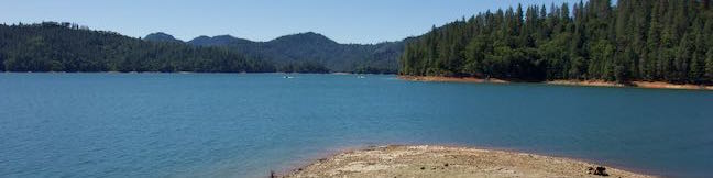
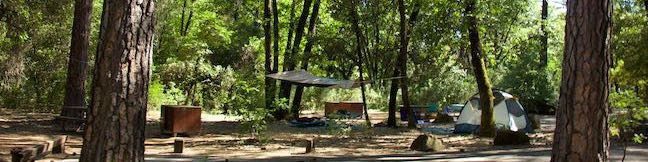
Below pines and oaks beside Shasta Lake, you'll find Antlers Campground. The campground is conveniently located just off Interstate 5 between Redding and Mount Shasta, but you won't hear much freeway noise (actually you'll hear more noise from jet skies and boaters enjoying the Sacramento Arm of Shasta Lake). The shaded campground is spread out on a series of loops over level terrain that... Read more.
TagsA green icon depicting a tags represents a list of words and phrases that this content is tagged with Tagged with · Shasta Lake · Shasta-Trinity National Forest · Tent Camping
By: Published: Last updated: January 2, 2018
Bailey Cove Trail Shasta Lake Hike Shasta-Trinity National Forest California
Bailey Cove Trail follows an easy path that weaves along the edges of a roughly triangle-shaped peninsula extends into Shasta Lake. A hill rises over the center of the peninsula, which is framed by finger-like coves on two sides. Lake views are present throughout this 3.1-mile hike and are grandest during the second mile. Bailey Cove Trail is fairly level, with just 50 feet of elevation... Read more.
My Hikes: Completed hikeA green icon of shows a picture of a landscape with a check mark in the upper right corner, signifying that this is a hike you would like to put on your completed list.OK! Add to trails I've hiked
My Hikes: Want to hikeA green icon of shows a picture of a landscape with a heart in the upper right corner, signifying that this is a hike you would like to put on your to-do list.OK! Add to trails I want to hike
TagsA green icon depicting a tags represents a list of words and phrases that this content is tagged with Tagged with · Lakes · Shasta-Trinity National Forest
Hike DistanceA green icon of a hiker used to label information about the length of the hike Distance: 3.1 miles · Elevation change: 50 feet
By: Published: Last updated: April 23, 2017
Chumash Trail Crespi Trail Hutash Trail Loop Morro Bay State Park San Luis Obispo hike California Turri Road
While it is one of the more inland hikes in Morro Bay State Park, the loop formed by connecting Chumash Trail, Crespi Trail, and Hutash Trail delivers ample coastal views as it leads to a lovely grove of coast live oaks. This lollipop loop covers 2.9 miles with 420 feet of elevation change. Hutash Trail can be trimmed from the circuit to lower the round trip distance to 2.55 miles and... Read more.
My Hikes: Completed hikeA green icon of shows a picture of a landscape with a check mark in the upper right corner, signifying that this is a hike you would like to put on your completed list.OK! Add to trails I've hiked
My Hikes: Want to hikeA green icon of shows a picture of a landscape with a heart in the upper right corner, signifying that this is a hike you would like to put on your to-do list.OK! Add to trails I want to hike
TagsA green icon depicting a tags represents a list of words and phrases that this content is tagged with Tagged with · California State Parks · Free Trails · Morro Bay · Morro Bay State Park · Ocean Views
Hike DistanceA green icon of a hiker used to label information about the length of the hike Distance: 2.9 miles · Elevation change: 420 feet
By: Published: Last updated: May 13, 2025
Terrace Hill Open Space hike San Luis Obispo California Terrace Hill Loop
An interesting chain of conical volcanoes, or volcanic plugs called the Morros, graces San Luis Obispo County. Terrace Hill is one of the smaller and harder to identify Morros within the city of San Luis Obispo County. Unlike the other Morros, Terrace Hill has a broad flat summit. The top of the hill was removed for use as construction material in the 1920s, leaving behind a flat mesa-like... Read more.
My Hikes: Completed hikeA green icon of shows a picture of a landscape with a check mark in the upper right corner, signifying that this is a hike you would like to put on your completed list.OK! Add to trails I've hiked
My Hikes: Want to hikeA green icon of shows a picture of a landscape with a heart in the upper right corner, signifying that this is a hike you would like to put on your to-do list.OK! Add to trails I want to hike
TagsA green icon depicting a tags represents a list of words and phrases that this content is tagged with Tagged with · Free Trails · Morros
Hike DistanceA green icon of a hiker used to label information about the length of the hike Distance: 0.55 miles · Elevation change: 110 feet
By: Published: Last updated: April 2, 2019
Dixie Canyon Park Hike Sherman Oaks Santa Monica Mountains
Dixie Canyon Park preserves twenty tucked-away acres in the Santa Monica Mountains on the north side of the range west of Coldwater Canyon. The park can be accessed from Sherman Oaks for a micro hike that is 0.55 miles round trip with 175 feet of elevation change. This partial loop follows a dirt single track that is narrow and sometime overgrown, finding shade from walnut trees and coast... Read more.
My Hikes: Completed hikeA green icon of shows a picture of a landscape with a check mark in the upper right corner, signifying that this is a hike you would like to put on your completed list.OK! Add to trails I've hiked
My Hikes: Want to hikeA green icon of shows a picture of a landscape with a heart in the upper right corner, signifying that this is a hike you would like to put on your to-do list.OK! Add to trails I want to hike
TagsA green icon depicting a tags represents a list of words and phrases that this content is tagged with Tagged with · Mountains Recreation and Conservation Authority · Sherman Oaks · Dog-Friendly Trails · Santa Monica Mountains
Hike DistanceA green icon of a hiker used to label information about the length of the hike Distance: 0.55 miles · Elevation change: 175 feet
By: Published: Last updated: January 14, 2019
Glendale Peak Hike Griffith Park Riverside Trail East Ridge Trail Henry's Trail to Glendale Peak Trail Los Angeles California
Mount Hollywood and Mount Lee might get the bulk of the summit-bagging hikers in Griffith Park, but Glendale Peak is a fine target of its own, hosting grand views of downtown Los Angeles, the San Gabriel Valley, and the San Gabriel Mountains. The 1,190-foot peak pokes out above the southeast side of Griffith Park at the end of a ridge that runs down from Mount Hollywood. Set out for Glendale... Read more.
My Hikes: Completed hikeA green icon of shows a picture of a landscape with a check mark in the upper right corner, signifying that this is a hike you would like to put on your completed list.OK! Add to trails I've hiked
My Hikes: Want to hikeA green icon of shows a picture of a landscape with a heart in the upper right corner, signifying that this is a hike you would like to put on your to-do list.OK! Add to trails I want to hike
TagsA green icon depicting a tags represents a list of words and phrases that this content is tagged with Tagged with · Free Trails · Hollywood · Summits · Dog-Friendly Trails · Griffith Park · Santa Monica Mountains
Hike DistanceA green icon of a hiker used to label information about the length of the hike Distance: 3.3 miles · Elevation change: 405 feet
By: Published: Last updated: May 13, 2025
Griffith Park Glendale Peak Mount Hollywood Loop Hike Griffith Park Los Angeles California
It is often said that two is better than one. Take a hike on Glendale Peak – Mount Hollywood Loop and you'll agree – two summits are better than one! Think of this Griffith Park hike like a meal with an appetizer and a main course. Glendale Peak is the appetizer, rising to 1,190 feet with tastier-than-expected views over southeast end of the park toward downtown Los Angeles and the San... Read more.
My Hikes: Completed hikeA green icon of shows a picture of a landscape with a check mark in the upper right corner, signifying that this is a hike you would like to put on your completed list.OK! Add to trails I've hiked
My Hikes: Want to hikeA green icon of shows a picture of a landscape with a heart in the upper right corner, signifying that this is a hike you would like to put on your to-do list.OK! Add to trails I want to hike
TagsA green icon depicting a tags represents a list of words and phrases that this content is tagged with Tagged with · Free Trails · Hollywood · Summits · Dog-Friendly Trails · Griffith Park · Santa Monica Mountains
Hike DistanceA green icon of a hiker used to label information about the length of the hike Distance: 4.15 miles · Elevation change: 765 feet
By: Published: Last updated: May 13, 2025
Strawberry Peak Trail San Gabriel Mountains Angeles National Forest Strawberry Peak Hike
Strawberry Peak holds the distinction of being the highest summit in the front range of the San Gabriel Mountains, besting nearby San Gabriel Peak by a just a yard. Measuring 6,164 feet tall, Strawberry Peak is taller than other surrounding mountains like Josephine Peak, Mount Lawlor, and Mount Wilson. A hike to the summit from Red Box Picnic Area on Angeles Crest Highway is 7.5 miles round... Read more.
My Hikes: Completed hikeA green icon of shows a picture of a landscape with a check mark in the upper right corner, signifying that this is a hike you would like to put on your completed list.OK! Add to trails I've hiked
My Hikes: Want to hikeA green icon of shows a picture of a landscape with a heart in the upper right corner, signifying that this is a hike you would like to put on your to-do list.OK! Add to trails I want to hike
TagsA green icon depicting a tags represents a list of words and phrases that this content is tagged with Tagged with · Altadena · Angeles National Forest · San Gabriel Mountains National Monument · Summits · Dog-Friendly Trails · Mountain Biking Trails · San Gabriel Mountains
Hike DistanceA green icon of a hiker used to label information about the length of the hike Distance: 7.5 miles · Elevation change: 1510 feet
By: Published: Last updated: May 13, 2025
Strawberry Peak Trail to Strawberry Meadow Hike San Gabriel Mountains National Monument Strawberry Potrero Angeles National Forest
Strawberry Meadow is an enticing area tucked away on the north side of Strawberry Peak below a massive granite cliff face. Walk into Strawberry Meadow and you might easily feel like you are somewhere in the Sierra Nevada Mountains, instead of hiking in the San Gabriel Mountains near Los Angeles. Find Strawberry Meadow next to a junction between Strawberry Peak Trail and Colby Canyon... Read more.
My Hikes: Completed hikeA green icon of shows a picture of a landscape with a check mark in the upper right corner, signifying that this is a hike you would like to put on your completed list.OK! Add to trails I've hiked
My Hikes: Want to hikeA green icon of shows a picture of a landscape with a heart in the upper right corner, signifying that this is a hike you would like to put on your to-do list.OK! Add to trails I want to hike
TagsA green icon depicting a tags represents a list of words and phrases that this content is tagged with Tagged with · Altadena · Angeles National Forest · San Gabriel Mountains National Monument · Dog-Friendly Trails · Mountain Biking Trails · San Gabriel Mountains
Hike DistanceA green icon of a hiker used to label information about the length of the hike Distance: 11 miles · Elevation change: 1600 feet
By: Published: Last updated: May 13, 2025
Josephine Peak Hike Colby Canyon Trail San Gabriel Mountains National Monument Angeles National Forest Josephine Saddle Josephine Peak Road
Want to hike to a mile-high summit in the San Gabriel Mountains with grand views over Los Angeles? Set your aim for Josephine Peak in the front range of the San Gabriel Mountains next to Strawberry Peak. Colby Canyon Trail offers a scenic route to the summit, traveling from Angeles Crest Highway up a withdrawn canyon to Josephine Saddle, a dip in the ridgeline west of Strawberry Peak. ... Read more.
My Hikes: Completed hikeA green icon of shows a picture of a landscape with a check mark in the upper right corner, signifying that this is a hike you would like to put on your completed list.OK! Add to trails I've hiked
My Hikes: Want to hikeA green icon of shows a picture of a landscape with a heart in the upper right corner, signifying that this is a hike you would like to put on your to-do list.OK! Add to trails I want to hike
TagsA green icon depicting a tags represents a list of words and phrases that this content is tagged with Tagged with · Altadena · Angeles National Forest · Free Trails · San Gabriel Mountains National Monument · Summits · Dog-Friendly Trails · San Gabriel Mountains
Hike DistanceA green icon of a hiker used to label information about the length of the hike Distance: 8.7 miles · Elevation change: 2050 feet
By: Published: Last updated: May 13, 2025