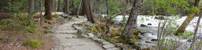
Camp 4 Campground Yosemite National Park Walk-in Campground Yosemite Valley California Tent camping
Camp 4 is a historic campground in Yosemite National Park – and that's not even hyperbole; the campground is listed with the National Register of Historic Places "for its significant association with the history of modern rock climbing in America." Reservations are needed at the other campgrounds in Yosemite Valley, but Camp 4 is the exception, with 35 shared first-come first serve walk-in... Read more.
By: Published: Last updated: January 7, 2019
Tenaja Falls Trail San Mateo Canyon Wilderness Santa Ana Mountains Waterfall Hike
Tenaja Falls pours over a sandstone staircase in the San Mateo Canyon Wilderness of the Santa Ana Mountains. Even through the waterfall's setting is picturesque and remote, the hike to the waterfall is a short and easy, following Tenaja Falls Trail for 1.5 miles round trip with 275 feet of elevation change. Totaling 150 feet in height with multiple tiers, this Southern California waterfall... Read more.
By: Published: Last updated: March 24, 2019
McAuley Peak 2049 Backbone Trail Piuma Trailhead Mesa Peak Motorway Milt McAuley hike Malibu California
Existing without an official name until 2015, McAuley Peak was already a convenient destination along the Backbone Trail, hosting a distinct rock formation and panoramic views over the surrounding Santa Monica Mountains. The name - honoring conservationist, author, and literal trailblazer Milt McAuley - adds even more heft to the peak. This hike to the 2,049-foot crown of McAuley Peak... Read more.
By: Published: Last updated: September 10, 2019
Phantom Trail Malibu Creek State Park Agoura Hills California
The beautiful Santa Monica Mountains can be a busy place to hike. One trail you can take to feel like a ghost (not see any other hikers) is Phantom Trail. Located on the north side of Malibu Creek State Park, this scarcely visited single track is not as popular as neighboring trails, but you'll be dumbfounded as to why when Phantom Trail provides early panoramas over the rest of the... Read more.
By: Published: Last updated: December 22, 2018
Wawona Swinging Bridge Trail Yosemite National Park Bridge Hike South Fork Merced River Swimming Hole Wawona California
Swinging Bridge in Yosemite Valley seduces photographers with views of Yosemite Falls. This is not a hike to that bridge, which isn't actually a swinging suspension bridge. This is a hike to Wawona Swinging Bridge, which has plenty of bounce in it's step, spanning a boulder-framed chute in the South Fork Merced River. Wawona Swinging Bridge is located at the south end of Yosemite National... Read more.
OK! Add to trails I’ve hiked
OK! Add to trails I want to hike
Tagged with · National Parks · Swimming Holes · Wawona
Distance: 0.7 miles · Elevation change: 70 feet
By: Published: Last updated: January 29, 2018
Wawona Meadow Loop Trail Yosemite National Park Wawona area day hike Wawona Hotel Walk Wawona Meadow Nature Trail
Wawona Meadow Loop Trail weaves through the forest surrounding a large meadow at the south end of Yosemite National Park, offering a relaxing hike that receives less attention than those in Yosemite Valley. Starting from trailheads on two sides of Wawona Hotel (Big Trees Lodge), Meadow Loop Trail follows an old road for 3.3 miles and can be connected by paths across the hotel ground for a... Read more.
OK! Add to trails I’ve hiked
OK! Add to trails I want to hike
Tagged with · National Parks · Nature Trails · Wawona
Distance: 3.9 miles · Elevation change: 250 feet
By: Published: Last updated: September 9, 2019
Corlieu Falls Hike Lewis Creek Trail Sierra National Forest Waterfall Oakhurst California
Yosemite National Park's waterfalls are the most famous in the Sierra, but they aren't the only gushers around. Falling close to the south entrance of Yosemite National Park is Corlieu Falls in Sierra National Forest. Heralded as the tallest waterfall Madera County, Corlieu Falls is an enthusiastic cascade, with several tiers dropping around 150 total feet. The hike down Lewis Creek Trail to... Read more.
OK! Add to trails I’ve hiked
OK! Add to trails I want to hike
Tagged with · Free Trails · Oakhurst · Waterfalls
Distance: 0.8 miles · Elevation change: 275 feet
By: Published: Last updated: June 30, 2021
Nelder Grove Campground Sierra National Forest Oakhurst California Sierra Nevada Camping Giant Sequoia Grove Campsites
Nelder Grove Campground has seven shaded sites set within a partially logged grove of giant sequoias in Sierra National Forest. This free campground with minimal amenities offers cozy woodland camping not far from the south entrance of Yosemite National Park. Nelder Grove Campground is a fine spot for a tucked-away night in the Sierra Nevada Mountains. Nelder Grove Campground has seven... Read more.
Tagged with · Nelder Grove · Oakhurst · Tent Camping
By: Published: Last updated: June 30, 2021
Shadow of the Giants Tree Trail Nelder Grove Giant Sequoia Hike Sierra National Forest Oakhurst California Shadow of the Giants Nature Trail
Within the Nelder Grove of Sierra National Forest, Shadow of the Giants Trail provides an informative stroll through a partially logged sequoia grove. Shadow of the Giants Trail is a self guided nature trail loaded with a couple dozen panels that describe giant sequoias and other surrounding plants. Shadow of the Giants Trail is 1.1 miles round trip with 200 feet of easy elevation change. ... Read more.
OK! Add to trails I’ve hiked
OK! Add to trails I want to hike
Tagged with · Closed · Free Trails · Nature Trails · Nelder Grove · Oakhurst · Sequoia Groves
Distance: 1.1 miles · Elevation change: 200 feet
By: Published: Last updated: May 14, 2024
Bull Buck Tree Trail Nelder Grove Giant Sequoia Hike Sierra National Forest Oakhurst California Bull Buck Tree Loop Trail
Want to see a giant sequoia that's really well grounded? Bull Buck Tree flares out toward the ground so dramatically that its base circumference rivals that of General Sherman Tree( the world's biggest giant Sequoia). Bull Buck Tree cannot compete with the largest giant sequoias by total volume, but it is still something to see! Like nearby Big Ed Tree Trail and Shadow of the Giants Trail,... Read more.
OK! Add to trails I’ve hiked
OK! Add to trails I want to hike
Tagged with · Free Trails · Nature Trails · Nelder Grove · Oakhurst · Sequoia Groves
Distance: 0.8 miles · Elevation change: 120 feet
By: Published: Last updated: June 30, 2021