Bull Buck Tree Trail in Sierra National Forest
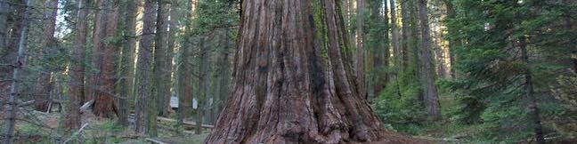
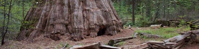
Want to see a giant sequoia that's really well grounded? Bull Buck Tree flares out toward the ground so dramatically that its base circumference rivals that of General Sherman Tree( the world's biggest giant Sequoia). Bull Buck Tree cannot compete with the largest giant sequoias by total volume, but it is still something to see! Like nearby Big Ed Tree Trail and Shadow of the Giants Trail, Bull Buck Tree Loop Trail explores part of the Nelder Grove in Sierra National Forest, south of Yosemite National Park. ...Read more.
Distance: 0.8 miles · Elevation change: 120 feet
By: Published: December 30, 2017 Last updated: April 10, 2026
Big Ed Tree Trail in Sierra National Forest
Seeing the big trees doesn't mean you have to go on a big hike. Big Ed Tree Trail is quick an easy, reaching its namesake giant sequoia after a tenth of a mile. Big Ed Tree stands within the Nelder Grove in Sierra National Forest, in the mountains south of Yosemite National Park. If this 0.2-mile round trip hike with 25 feet of elevation change leaves you wanting more, check out the adjacent exhibits about the area's logging history. ...Read more.
Distance: 0.2 miles · Elevation change: 25 feet
By: Published: December 23, 2017 Last updated: December 12, 2025
Reservoir Canyon Trail – Summit Trail Loop in Reservoir Canyon Natural Reserve
If you've hiked up the hill east of downtown San Luis Obispo on Reservoir Canyon Trail or Summit Trail, you've probably pondered the prospect of connecting the two hikes in order to spend more time enjoying grand views over San Luis Obispo County. Follow Reservoir Canyon Trail up to a stone bench viewpoint, cross Ridge Trail to an old tower housing a bell, and descend Summit Trail to complete a 5. ...Read more.
Distance: 5.6 miles · Elevation change: 1350 feet
By: Published: July 13, 2017 Last updated: December 5, 2025
Summit Trail in Reservoir Canyon Natural Reserve
You'll give a ringing endorsement to this San Luis Obispo hike! Reservoir Canyon's Summit Trail ascends to sweeping panoramas over San Luis Obispo and an old tower with a bell that you can ring with a pebble. The hike from Reservoir Canyon to the High School Hill Tower is 4.1 miles round trip with 1,175 feet of elevation change. Expand your horizons from there by following Ridge Trail up to the high point of Murray Hill and descend Reservoir Canyon Trail on the 5. ...Read more.
Distance: 4.1 miles · Elevation change: 1175 feet
By: Published: July 12, 2017 Last updated: April 8, 2026
Hollywood Sign – Hollywood Reservoir Loop in Los Angeles
You might not realize that Hollywood has a lake until you look down on it from the top of Mount Lee by the Hollywood Sign. Numerous hikes lead to the Hollywood Sign and a level hiking trail wraps around Lake Hollywood Reservoir. To visit the Hollywood Sign, three peaks on the west side of Griffith Park, and Lake Hollywood, set out on the Hollywood Sign – Hollywood Reservoir Loop. ...Read more.
Distance: 7.4 miles · Elevation change: 1070 feet
By: Published: May 31, 2017 Last updated: April 18, 2026
Burbank Peak Trail in Griffith Park
Burbank Peak is a summit-like perch at the end of a ridge extending west from Cahuenga Peak, the highest point in Griffith Park. Hikers have many reasons to reach the top of Burbank Peak. One popular motivation is delivering a message to the Wisdom Tree, a long pine on Burbank Peak that rises above the surrounding brush. The viewpoint also hosts an America Flag in honor of September Eleventh and views over Hollywood and the San Fernando Valley. ...Read more.
Distance: 1.6 miles · Elevation change: 740 feet
By: Published: May 25, 2017 Last updated: April 25, 2026
The Hollywood Sign via Innsdale Drive, Mulholland Highway, and Mount Lee Drive in Griffith Park
With the public access closure of the trailhead at the top of Beachwood Drive for the Hollyridge Trail, hikers have lost a key route to the Hollywood Sign on Mount Lee. Those wanting to hike to the sign are now being encouraged to start up Brush Canyon Trail from a trailhead on Canyon Drive for a 6.4-mile hike to Mount Lee's famous sign. While this is a great option for those with the time and energy for a longer hike in the park, a shorter route still exists that presents superb Hollywood Sign views from the get-go. ...Read more.
Distance: 4.6 miles · Elevation change: 750 feet
By: Published: May 24, 2017 Last updated: April 7, 2026
Hazard Peak via Bloody Nose Trail, Hiedra Trail, and Hazard Peak Trail in Montaña de Oro State Park
The panoramic summit of Hazard Peak in Montaña de Oro State Park has excellent coastal views. Hazard Peak Trail is the most obvious route to the top and a great choice, rising to the 1,076-foot summit over 3 miles. A junction partway up Hazard Peak Trail makes it possible to add a couple other trails to the approach. Bloody Nose Trail and Hiedra Trail are a combined 0. ...Read more.
Distance: 5.55 miles · Elevation change: 950 feet
By: Published: May 20, 2017 Last updated: April 8, 2026
South Dune Trail – Bloody Nose Trail – Hiedra Trail – Hazard Peak Trail Loop in Montaña de Oro State Park
Hikes in Montaña de Oro State Park travel along the coast or delve inland into canyons and up peaks. If you want a mix of hiking environments, consider this four-trail loop, which combines South Dune Trail, Bloody Nose Trail, Hiedra Trail, and Hazard Peak Trail for a 2 2/3 mile round trip hike with a little over 300 feet of elevation change. This loop can be added to the hike up Hazard Peak, adding a loop to summit hike for a just over 6. ...Read more.
Distance: 2.67 miles · Elevation change: 310 feet
By: Published: May 11, 2017 Last updated: April 11, 2026
Rinconada Trail and Bell Mountain in the Santa Lucia Mountains
Rising through grassy meadows, oak woodlands, and chaparral slopes, Rinconada Trail provides North County access to the Santa Lucia Mountains in Los Padres National Forest. Gaze over bucolic valleys on the hike up to a high point in a grassy mountain pass with views over remote ridges and canyons in the Santa Lucia Wilderness. Turn around at an overlook by the crest of Rinconada Trail for a 3-mile round trip hike with 625 feet of elevation change. ...Read more.
Distance: 3 miles · Elevation change: 625 feet
By: Published: April 25, 2017 Last updated: April 18, 2026