Rocky Peak Park summit hike Simi Valley Los Angeles California
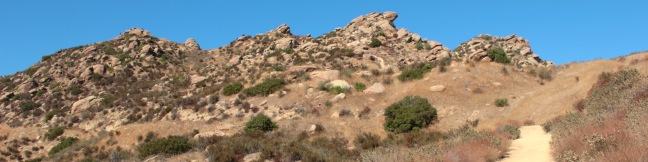
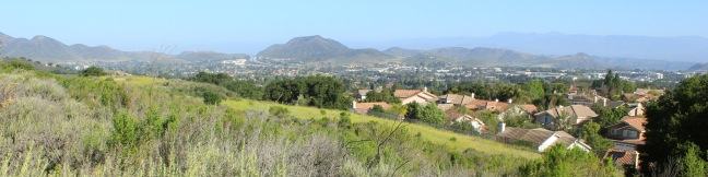
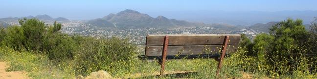
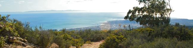
Rocky Peak is a panoramic 2,715-foot summit on the border between Los Angeles and Ventura counties in the Santa Susana Mountains. The county line-straddling peak stands at the center of a 4,800-acre park bearing the same name. The shortest hike to Rocky Peak takes Rocky Peak Trail from Rocky Peak Road through Rocky Peak Park. Oh boy, we're off to a rocky start... The first two miles of... Read more.
My Hikes: Completed hikeA green icon of shows a picture of a landscape with a check mark in the upper right corner, signifying that this is a hike you would like to put on your completed list.OK! Add to trails I've hiked
My Hikes: Want to hikeA green icon of shows a picture of a landscape with a heart in the upper right corner, signifying that this is a hike you would like to put on your to-do list.OK! Add to trails I want to hike
TagsA green icon depicting a tags represents a list of words and phrases that this content is tagged with Tagged with · Free Trails · Mountains Recreation and Conservation Authority · Santa Susana Mountains · Simi Valley · Summits · Wind Caves · Dog-Friendly Trails · Mountain Biking Trails
Hike DistanceA green icon of a hiker used to label information about the length of the hike Distance: 4.75 miles · Elevation change: 900 feet
By: Published: Last updated: December 7, 2018
Cruickshank Trail Silver Peak Wilderness Los Padres National Forest Big Sur Hike
For backpackers and day hikers, Cruickshank Trail offers an extraordinary opportunity to explore the wilderness off Highway One on the beautiful Big Sur Coast. The single track starts by climbing to lofty ocean views, and then heads inland along a canyon wall with relaxing pockets of oaks and redwoods toward a handful of trail camps. The excellent trail to Upper Cruickshank Camp crosses... Read more.
My Hikes: Completed hikeA green icon of shows a picture of a landscape with a check mark in the upper right corner, signifying that this is a hike you would like to put on your completed list.OK! Add to trails I've hiked
My Hikes: Want to hikeA green icon of shows a picture of a landscape with a heart in the upper right corner, signifying that this is a hike you would like to put on your to-do list.OK! Add to trails I want to hike
TagsA green icon depicting a tags represents a list of words and phrases that this content is tagged with Tagged with · Backpacking · Big Sur · Free Trails · Los Padres National Forest · Ocean Views · Silver Peak Wilderness · Trail Camp · Walk-in Camping
Hike DistanceA green icon of a hiker used to label information about the length of the hike Distance: 5 miles · Elevation change: 1150 feet
By: Published: Last updated: July 20, 2018
Buckeye Trail Silver Peak Wilderness Los Padres National Forest Big Sur Hike Buckeye Camp
It can sound like hyperbole when you try to put into words the breathtaking, jaw-dropping stop-you-in-your tracks ocean views found on trails in Big Sur. Never the less, Buckeye Trail has absolutely extraordinary views over the Pacific that you need to see to believe. Rising above Highway One, the trail ventures through the Silver Peak Wilderness, ascending coastal canyons and ridges to... Read more.
My Hikes: Completed hikeA green icon of shows a picture of a landscape with a check mark in the upper right corner, signifying that this is a hike you would like to put on your completed list.OK! Add to trails I've hiked
My Hikes: Want to hikeA green icon of shows a picture of a landscape with a heart in the upper right corner, signifying that this is a hike you would like to put on your to-do list.OK! Add to trails I want to hike
TagsA green icon depicting a tags represents a list of words and phrases that this content is tagged with Tagged with · Backpacking · Big Sur · Free Trails · Los Padres National Forest · Ocean Views · Silver Peak Wilderness · Trail Camp · Walk-in Camping
Hike DistanceA green icon of a hiker used to label information about the length of the hike Distance: 6.5 miles · Elevation change: 1450 feet
By: Published: Last updated: July 20, 2018
Bob Jones City to Sea Bike Trail San Luis Obispo Avila Beach Avila Valley hike ride
Are you jonesing for an easy trail that leads to a beach town brimming with oceanfront fun? Take a relaxing trip down Bob Jones Bike Trail to Avila Beach, a small bayside hamlet that can bustle with beachgoers on weekends. The level 5-mile round trip trail is suitable for hikers, joggers, walkers, and bikers. You will enjoy refreshing shade from oaks as you follow San Luis Obispo Creek... Read more.
My Hikes: Completed hikeA green icon of shows a picture of a landscape with a check mark in the upper right corner, signifying that this is a hike you would like to put on your completed list.OK! Add to trails I've hiked
My Hikes: Want to hikeA green icon of shows a picture of a landscape with a heart in the upper right corner, signifying that this is a hike you would like to put on your to-do list.OK! Add to trails I want to hike
TagsA green icon depicting a tags represents a list of words and phrases that this content is tagged with Tagged with · Avila Beach · Avila Valley · Bike Trail · Creeks · Ocean Views
Hike DistanceA green icon of a hiker used to label information about the length of the hike Distance: 5 miles · Elevation change: 50 feet
By: Published: Last updated: April 23, 2017
Chumash Painted Cave State Historic Park Santa Barbara California Los Padres National Forest Painted Cave Road
Chumash Painted Cave State Historic Park preserves centuries old Native American artwork that graces the wall of a sandstone cave in the Santa Ynez Mountains behind Santa Barbara. Chumash Painted Cave can be reached by walking a couple hundred feet up a trail on Painted Cave Road. The trailhead is just two miles from California Route 154, making it a quick, convenient, and interesting stop... Read more.
My Hikes: Completed hikeA green icon of shows a picture of a landscape with a check mark in the upper right corner, signifying that this is a hike you would like to put on your completed list.OK! Add to trails I've hiked
My Hikes: Want to hikeA green icon of shows a picture of a landscape with a heart in the upper right corner, signifying that this is a hike you would like to put on your to-do list.OK! Add to trails I want to hike
TagsA green icon depicting a tags represents a list of words and phrases that this content is tagged with Tagged with · California State Parks · Caves · Free Trails · Santa Ynez Mountains
Hike DistanceA green icon of a hiker used to label information about the length of the hike Distance: 0.1 miles · Elevation change: 20 feet
By: Published: Last updated: February 5, 2025
Emma Wood State Beach Campground Ventura County California RV camp camper camping
Want to beach camp in Ventura, California? For RV campers, the place to go is Emma Wood State Beach. The park offers 90 beachfront campsites, ocean fishing, a reliable surf break, and a 1.5-mile hiking trail loop. Ready for a beach escape? The campground in this 115-acre park is popular, booking up solid throughout the summer. The sites run along a cobblestone beach with easy access to... Read more.
TagsA green icon depicting a tags represents a list of words and phrases that this content is tagged with Tagged with · California State Parks · Emma Wood State Beach · Ocean Views
By: Published: Last updated: February 5, 2025
Emma Wood State Beach hike Ventura County Ocean's Edge Trail River's Edge Trail Ventura River Estuary Seaside Wilderness Park
Emma Wood State Beach borders both the Pacific Ocean and the Ventura River. There is an estuary where the two meet, where you can sprawl out on soft sand and watch the gathering marine birds. See the beach, the river, and the estuary on a level and easy 1.5-mile loop through Emma Wood State Beach and the adjacent Seaside Wilderness Park in Ventura. Starting within the 115-acre state... Read more.
My Hikes: Completed hikeA green icon of shows a picture of a landscape with a check mark in the upper right corner, signifying that this is a hike you would like to put on your completed list.OK! Add to trails I've hiked
My Hikes: Want to hikeA green icon of shows a picture of a landscape with a heart in the upper right corner, signifying that this is a hike you would like to put on your to-do list.OK! Add to trails I want to hike
TagsA green icon depicting a tags represents a list of words and phrases that this content is tagged with Tagged with · California State Parks · Emma Wood State Beach · Ocean Views · Ventura River
Hike DistanceA green icon of a hiker used to label information about the length of the hike Distance: 1.5 miles · Elevation change: 25 feet
By: Published: Last updated: February 12, 2018
Angel Vista Rosewood Trail Thousand Oaks California
The boldly named Angel Vista is one of the top viewpoints in the Santa Monica Mountains, a coastal range running between Los Angeles and Ventura. Angel Vista soars over Thousand Oaks, presenting panoramic views of the west end of the range, which includes the Boney Mountains, the rocky crown of Santa Monicas. A few trails lead to the vista point, including the 7.6-mile round trip trek up... Read more.
My Hikes: Completed hikeA green icon of shows a picture of a landscape with a check mark in the upper right corner, signifying that this is a hike you would like to put on your completed list.OK! Add to trails I've hiked
My Hikes: Want to hikeA green icon of shows a picture of a landscape with a heart in the upper right corner, signifying that this is a hike you would like to put on your to-do list.OK! Remove from trails I want to hike
TagsA green icon depicting a tags represents a list of words and phrases that this content is tagged with Tagged with · Free Trails · Los Robles Open Space · Thousand Oaks · Dog-Friendly Trails · Mountain Biking Trails · Santa Monica Mountains
Hike DistanceA green icon of a hiker used to label information about the length of the hike Distance: 4 miles · Elevation change: 850 feet
By: Published: Last updated: January 10, 2018
Angel Vista West Los Robles Trail Thousand Oaks California hike
Los Robles Trail in Thousand Oaks crosses a chaparral-covered mountainside leading to Angel Vista, one of the premier overlooks on the north side of the Santa Monica Mountains. There are a few routes to the viewpoint, including this 7.6-mile round trip hike up the east end of West Los Robles Trail. The hike charts a steady course along a mountain slope, gaining 800 feet to reach the vista... Read more.
My Hikes: Completed hikeA green icon of shows a picture of a landscape with a check mark in the upper right corner, signifying that this is a hike you would like to put on your completed list.OK! Add to trails I've hiked
My Hikes: Want to hikeA green icon of shows a picture of a landscape with a heart in the upper right corner, signifying that this is a hike you would like to put on your to-do list.OK! Add to trails I want to hike
TagsA green icon depicting a tags represents a list of words and phrases that this content is tagged with Tagged with · Free Trails · Los Robles Open Space · Newbury Park · Thousand Oaks · Dog-Friendly Trails · Mountain Biking Trails · Santa Monica Mountains
Hike DistanceA green icon of a hiker used to label information about the length of the hike Distance: 7.6 miles · Elevation change: 800 feet
By: Published: Last updated: April 26, 2017
Montecito Peak hike Cold Springs Trail Santa Barbara California Montecito Mountain Summit Cold Spring
The Santa Ynez Mountains form a verdant backdrop behind Santa Barbara. One of the highest summits in the range is Montecito Peak, which offers sensational views over the coastal cities below and the Pacific Ocean beyond. The 3,214-foot peak can be reached via a demanding 7.1-mile round trip hike with 2,450 feet of elevation change. It is quite a trek, but the ever-expanding ocean views will... Read more.
My Hikes: Completed hikeA green icon of shows a picture of a landscape with a check mark in the upper right corner, signifying that this is a hike you would like to put on your completed list.OK! Add to trails I've hiked
My Hikes: Want to hikeA green icon of shows a picture of a landscape with a heart in the upper right corner, signifying that this is a hike you would like to put on your to-do list.OK! Add to trails I want to hike
TagsA green icon depicting a tags represents a list of words and phrases that this content is tagged with Tagged with · Creeks · Free Trails · Los Padres National Forest · Montecito · Ocean Views · Santa Ynez Mountains · Summits
Hike DistanceA green icon of a hiker used to label information about the length of the hike Distance: 7.1 miles · Elevation change: 2450 feet
By: Published: Last updated: April 26, 2017