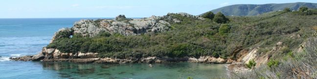
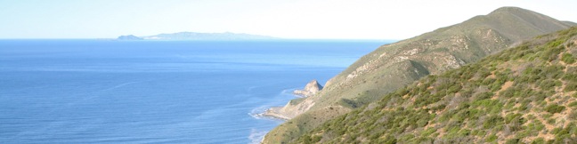
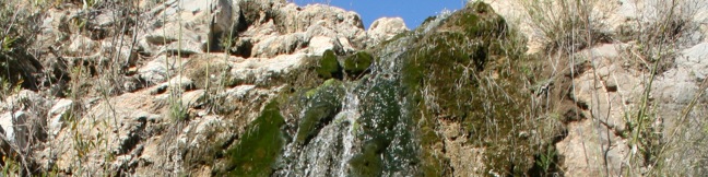
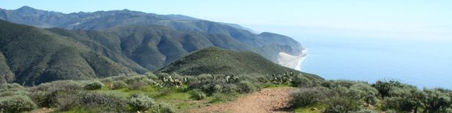
Gaviota Hot Springs Trail Los Padres Santa Barbara hike Gaviota State Park spring
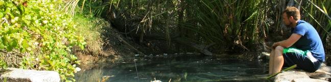
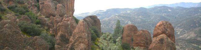
Driving up Highway 101 through the Gaviota Tunnel west of Santa Barbara, you might be unaware that a natural hot springs is less than a mile from the roadway. Gaviota Hot Springs is more warm than it is hot, but the blue sulfery water attracts its share of bathers. The springs are half a mile from the trailhead and only a tenth of a mile off the trail to Gaviota Peak, making it a nice... Read more.
My Hikes: Completed hikeA green icon of shows a picture of a landscape with a check mark in the upper right corner, signifying that this is a hike you would like to put on your completed list.OK! Add to trails I've hiked
My Hikes: Want to hikeA green icon of shows a picture of a landscape with a heart in the upper right corner, signifying that this is a hike you would like to put on your to-do list.OK! Add to trails I want to hike
TagsA green icon depicting a tags represents a list of words and phrases that this content is tagged with Tagged with · California State Parks · Gaviota State Park · Goleta · Hot Springs · Santa Ynez Mountains
Hike DistanceA green icon of a hiker used to label information about the length of the hike Distance: 1 mile · Elevation change: 400 feet
By: Published: Last updated: May 22, 2017
Lemon Grove Loop Trail San Luis Obispo hike Cerro San Luis Madonna Mountain Lemon Grove Loop Trail Hike
This 2.2-mile loop explores a 120-acre open space between Cerro San Luis and downtown San Luis Obispo. With just three hundred feet of elevation gain, this is a quick hike on its own, or an easy extension to the steeper trek up Cerro San Luis. The abandoned lemon grove that gives the trail its name is becoming more of a destination thanks to the planting of new trees. The open skies and... Read more.
My Hikes: Completed hikeA green icon of shows a picture of a landscape with a check mark in the upper right corner, signifying that this is a hike you would like to put on your completed list.OK! Add to trails I've hiked
My Hikes: Want to hikeA green icon of shows a picture of a landscape with a heart in the upper right corner, signifying that this is a hike you would like to put on your to-do list.OK! Add to trails I want to hike
TagsA green icon depicting a tags represents a list of words and phrases that this content is tagged with Tagged with · Free Trails · Morros
Hike DistanceA green icon of a hiker used to label information about the length of the hike Distance: 2.2 miles · Elevation change: 300 feet
By: Published: Last updated: May 13, 2025
Cerro San Luis Mountain Summit trail San Luis Obispo Hike Madonna Mountain
Located just west of downtown San Luis Obispo, the 1,292-foot Cerro San Luis (or San Luis Mountain) offers sweeping views over the city and surroundings. Cerro San Luis is a member of the Morros, or Nine Sisters, a chain of prominent volcanic peaks stretching east from Morro Bay. These beautiful peaks set the postcard-like backdrop for San Luis Obispo and are excellent places to hike. ... Read more.
My Hikes: Completed hikeA green icon of shows a picture of a landscape with a check mark in the upper right corner, signifying that this is a hike you would like to put on your completed list.OK! Add to trails I've hiked
My Hikes: Want to hikeA green icon of shows a picture of a landscape with a heart in the upper right corner, signifying that this is a hike you would like to put on your to-do list.OK! Add to trails I want to hike
TagsA green icon depicting a tags represents a list of words and phrases that this content is tagged with Tagged with · Free Trails · Morros · Summits
Hike DistanceA green icon of a hiker used to label information about the length of the hike Distance: 4 miles · Elevation change: 1100 feet
By: Published: Last updated: May 13, 2025
Sycamore Crest Trail - Ontario Hill - Avila Valley - Sycamore Mineral Springs Resort hike
Sycamore Crest Trail is a wide dirt road on the north slope of Ontario Hill, which runs east to west between Shell Beach and Avila Beach. Beginning from Sycamore Mineral Springs Resort in Avila Valley, the trail climbs through a lush oak grove to reach a junction with Ontario Ridge Trail at a south-facing saddle with lofty ocean views. Sycamore Crest Trail serves as a 1.75-mile out and back... Read more.
My Hikes: Completed hikeA green icon of shows a picture of a landscape with a check mark in the upper right corner, signifying that this is a hike you would like to put on your completed list.OK! Add to trails I've hiked
My Hikes: Want to hikeA green icon of shows a picture of a landscape with a heart in the upper right corner, signifying that this is a hike you would like to put on your to-do list.OK! Add to trails I want to hike
TagsA green icon depicting a tags represents a list of words and phrases that this content is tagged with Tagged with · Avila Valley · Free Trails · Ocean Views
Hike DistanceA green icon of a hiker used to label information about the length of the hike Distance: 1.75 miles · Elevation change: 575 feet
By: Published: Last updated: May 13, 2025
Ontario Hill Ridge Trail Shell Beach Bluff Trail Avila hike ontario ridge to pirate's cove
Two parallel but varied trails explore the coast between Shell Beach and Avila Beach in San Luis Obispo County. Shell Beach Bluff Trail is an easy, wheelchair-friendly paved trail overlooking a picturesque cove. Ontario Ridge Trail is a rugged, sometimes-steep track crossing a 700-foot hill above the bluff. Put these two together for a 2.8-mile loop with 675 feet of elevation change and... Read more.
My Hikes: Completed hikeA green icon of shows a picture of a landscape with a check mark in the upper right corner, signifying that this is a hike you would like to put on your completed list.OK! Add to trails I've hiked
My Hikes: Want to hikeA green icon of shows a picture of a landscape with a heart in the upper right corner, signifying that this is a hike you would like to put on your to-do list.OK! Add to trails I want to hike
TagsA green icon depicting a tags represents a list of words and phrases that this content is tagged with Tagged with · Free Trails · Ocean Views · Pismo Beach · Summits
Hike DistanceA green icon of a hiker used to label information about the length of the hike Distance: 2.8 miles · Elevation change: 675 feet
By: Published: Last updated: June 2, 2017
Pirates Cave Trail Avila Beach Cave Landing Pirate Cove Whales Cave hike
This half-mile round trip hike visits a small rock bridge at the end of a dramatic headland east of Avila Beach. The hike down Cave Landing to the natural tunnel sometimes called Pirate's Cave provides outstanding coastal views over the beach cities of San Luis Obispo County. This is a short, easy, and enjoyable trek with 100 feet of elevation change - a perfect excursion for anyone staying... Read more.
My Hikes: Completed hikeA green icon of shows a picture of a landscape with a check mark in the upper right corner, signifying that this is a hike you would like to put on your completed list.OK! Add to trails I've hiked
My Hikes: Want to hikeA green icon of shows a picture of a landscape with a heart in the upper right corner, signifying that this is a hike you would like to put on your to-do list.OK! Remove from trails I want to hike
TagsA green icon depicting a tags represents a list of words and phrases that this content is tagged with Tagged with · Avila Beach · Free Trails · Ocean Views
Hike DistanceA green icon of a hiker used to label information about the length of the hike Distance: 0.5 miles · Elevation change: 100 feet
By: Published: Last updated: June 2, 2017
Mugu Peak Trail Point Mugu State Park hike malibu ocean view santa monica mountains trek Mugu Peak Hike
Just inland from that similarly named point along the California coast, Mugu Peak towers over the Pacific Ocean from an elevation of 1,266 feet. The hike from the bottom of nearby La Jolla Canyon to the top of Mugu Peak is 6.5 miles round trip with 1,225 feet of elevation gain. This is a strenuous trek, rewarded by ridiculous scenery. There is also a longer way to reach the peak, the... Read more.
My Hikes: Completed hikeA green icon of shows a picture of a landscape with a check mark in the upper right corner, signifying that this is a hike you would like to put on your completed list.OK! Add to trails I've hiked
My Hikes: Want to hikeA green icon of shows a picture of a landscape with a heart in the upper right corner, signifying that this is a hike you would like to put on your to-do list.OK! Add to trails I want to hike
TagsA green icon depicting a tags represents a list of words and phrases that this content is tagged with Tagged with · California State Parks · Malibu · Newbury Park · Ocean Views · Point Mugu State Park · Summits
Hike DistanceA green icon of a hiker used to label information about the length of the hike Distance: 6.5 miles · Elevation change: 1225 feet
By: Published: Last updated: February 19, 2018
La Jolla Canyon Falls hike Point Mugu State Park La Jolla Canyon Malibu California Pacific Ocean Santa Monica Mountains waterfall trek
La Jolla Canyon Falls is a short seasonal waterfall located 3/4 of a mile up La Jolla Canyon Trail in Point Mugu State Park. The twenty-foot cascade offers one of the easiest hikes in the park, with just 250 feet of elevation between the trailhead and the falls. La Jolla Canyon Trail continues above the waterfall, ascending a rocky V-shaped canyon. If you choose to hike farther, the... Read more.
My Hikes: Completed hikeA green icon of shows a picture of a landscape with a check mark in the upper right corner, signifying that this is a hike you would like to put on your completed list.OK! Add to trails I've hiked
My Hikes: Want to hikeA green icon of shows a picture of a landscape with a heart in the upper right corner, signifying that this is a hike you would like to put on your to-do list.OK! Add to trails I want to hike
TagsA green icon depicting a tags represents a list of words and phrases that this content is tagged with Tagged with · California State Parks · Malibu · Newbury Park · Point Mugu State Park · Waterfalls · Los Angeles Waterfalls · Santa Monica Mountains
Hike DistanceA green icon of a hiker used to label information about the length of the hike Distance: 1.5 miles · Elevation change: 250 feet
By: Published: Last updated: February 19, 2018
Point Mugu State Park La Jolla Canyon Ray Miller Trail Mugu Peak Trail valley loop hike Malibu California Pacific Ocean Views
Point Mugu State Park protects 15,000 acres of rustic wilderness on the west end of the Santa Monica Mountains between Oxnard and Malibu. More than 70 miles of trails explore this sprawling park, leaving hikers with options. An excellent way to experience Point Mugu State Park is to set out on a daunting and rewarding 11.75-mile loop. Start at the mouth of La Jolla Canyon just across... Read more.
My Hikes: Completed hikeA green icon of shows a picture of a landscape with a check mark in the upper right corner, signifying that this is a hike you would like to put on your completed list.OK! Add to trails I've hiked
My Hikes: Want to hikeA green icon of shows a picture of a landscape with a heart in the upper right corner, signifying that this is a hike you would like to put on your to-do list.OK! Add to trails I want to hike
TagsA green icon depicting a tags represents a list of words and phrases that this content is tagged with Tagged with · Backbone Trail · Backpacking · California State Parks · Closed · Malibu · Newbury Park · Ocean Views · Point Mugu State Park · Summits · Waterfalls · Santa Monica Mountains
Hike DistanceA green icon of a hiker used to label information about the length of the hike Distance: 11.75 miles · Elevation change: 1225 feet
By: Published: Last updated: May 18, 2024
High Peaks Trail Pinnacles National Monument hike High Peaks trail California Pinnacles National Park
The High Peaks of Pinnacles National Park (formerly known as Pinnacles National Monument) are a one-of-a-kind collection of sky-pointed spires that provide fascinating scenery and a robust hiking experience. The adventurous hike across the top of the Pinnacles crosses a steep, narrow, and impressively constructed trail that is a highlight of any visit to the park. The High Peaks can be... Read more.
My Hikes: Completed hikeA green icon of shows a picture of a landscape with a check mark in the upper right corner, signifying that this is a hike you would like to put on your completed list.OK! Add to trails I've hiked
My Hikes: Want to hikeA green icon of shows a picture of a landscape with a heart in the upper right corner, signifying that this is a hike you would like to put on your to-do list.OK! Add to trails I want to hike
TagsA green icon depicting a tags represents a list of words and phrases that this content is tagged with Tagged with · Bouldering · National Parks · Paicines · Summits
Hike DistanceA green icon of a hiker used to label information about the length of the hike Distance: 6 miles · Elevation change: 1325 feet
By: Published: Last updated: January 9, 2018