Hikes in Kings Canyon National Park
While perhaps not as famous as the other national parks California’s Sierra Nevada Mountains (Yosemite National Park and Sequoia National Park), Kings Canyon can sure compete with those other parks where it counts – natural beauty.
Highlights of Kings Canyon National Park


Kings Canyon National Park
Kings Canyon National Park is split into two pieces.
One section contains Grant Grove, home of the General Grant Tree, the world’s third largest tree, and Redwood Mountains Grove, the world’s biggest giant sequoia grove (and a real hiker haven).
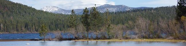
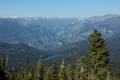
Another much larger section of the park contains Kings Canyon itself, where stunning snowy summits rise above 2,000-foot tall sheer canyon walls. There is only one road into this enormous backcountry playground, ending at Cedar Grove in the bottom of the canyon.
Before Kings Canyon National Park, there was General Grant National Park, established in 1890 (the same year as Sequoia National Park) to protect the giant sequoias in the Grant Grove. In 1940, Kings Canyon National Park was created, covering 720 square miles and absorbing General Grant National Park.
Kings Canyon National Park borders Sequoia National Park and the National Park Service manages the two parks like one massive 1,350 square mile entity. The combined parks have fourteen campgrounds to accommodate visitors and there are additional campgrounds in the Hume Lake Ranger District of Sequoia National Forest, which also borders the two national parks.
The scenic Generals Highway (Routes 180 and 198) is the main road through the park, passing the Redwood Mountain Grove and General Grant Grove before coming to an end at Cedar Grove in Kings Canyon.
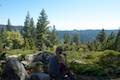
Grant Grove is a 30-mile drive from the Giant Forest in Sequoia National Park (home of the world’s largest tree, the General Sherman Tree), making it easy for hikers to visit the big trees in both parks. It is a longer drive down to Cedar Grove, but you can actually get a good a good view of Kings Canyon right near Grant Village at Panoramic Point.
Kings Canyon National Park Hiking
This collection of trails in Kings Canyon National Park lists hikes from north to south and west to east. The table may also be sorted alphabetically or by distance to help you pick your next hike. Each trail links to its own report complete with photos, maps, directions, and all the other information needed to locate and enjoy these trails. Below the table is an interpretive map showing the location of each hike.
Trail | Description | Distance | Location |
|---|---|---|---|
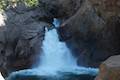 264 264 | Roaring River Falls This paved out and back hike reaches a thundering little waterfall on a tributary of the Kings River. | 0.3 miles 25 feet | 36.783747, -118.622121 |
 266 266 | Kanawyer Loop Trail This loop is scenic and easy, exploring east from the backcountry gateway at Road's End along both sides of the South Fork Kings River in Kings Canyon. | 5 miles 125 feet | 36.794663, -118.582941 |
 270 270 | Panoramic Point This short out and back hike reaches an exception overlook with views into Kings Canyon. | 0.5 miles 100 feet | 36.753793, -118.946754 |
 280 280 | North Boundary Trail This lollipop loop hike starts on the trail between Grant Grove and Grant Village and passes the General Grant Tree to reach a 2.75-mile loop through the pine forest north of the Grant Grove. | 3.55 miles 375 feet | 36.746811, -118.972595 |
 284 284 | General Grant Tree Trail This loop in the Grant Grove passes through a Fallen Monarch to reach the General Grant Tree, one of the world's largest sequoias. | 0.8 miles 50 feet | 36.747, -118.973128 |
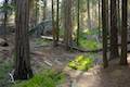
 286 286 | North Grove Trail This loop explores a quiet grove of sequoias near the crowded Grant Grove and can combine with Dead Giant Loop Trail for 3.25-mile hike. | 2 miles 350 feet | 36.747103, -118.974642 |
 288 288 | Dead Giant Loop Trail This loop passes a small meadow and a large dead sequoia to reach Sequoia Lake Overlook and can combine with nearby North Grove Trail for 3.25-mile hike. | 2.25 miles 300 feet | 36.747103, -118.974642 |
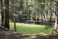
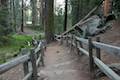 290 290 | Grant Village to Grant Grove Trail This mile-long trail connects the visitor center at Grant Village with the parking lot at Grant Grove, passing through Azalea Campground to reach giant sequoias, including the General Grant Tree. | 2 miles 250 feet | 36.740049, -118.963588 |
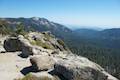 295 295 | Buena Vista Peak This out and back hike reaches a granite summit with 360-degree views over the Redwood Mountain Grove and Kings Canyon. | 2 miles 420 feet | 36.718234, -118.896935 |
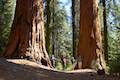 297 297 | Hart Tree and Fallen Goliath Loop This loop on Hart Tree Trail and Redwood Creek Trail passes tranquil streams and interesting sequoias in the Redwood Mountain Grove. | 8.3 miles 925 feet | 36.707444, -118.92093 |
Or explore hikes around Kings Canyon National Park on the Hike Finder Map