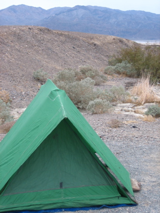
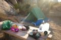
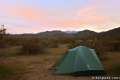
Nine campgrounds are open to visitors within the boundaries of Death Valley National Park. Texas Spring Campground near Furnace Creek is centrally located and one of the nicer campgrounds in Death Valley, with bushes and short trees providing shade. Some of the other campgrounds are not California’s most impressive, offering little more than open gravel landscapes for setting up tents. Still, Death Valley camping is a rewarding experience.
Campgrounds in Death Valley National Park vary in size and amenities. The list below offers more information about each campground and the map at the bottom of this page displays their locations. Because of the extreme temperatures in Death Valley, many of the campground close during the summer months, leaving visitors to pick from the higher elevation campgrounds.
Furnace Creek Campground is the only campground in the park to take reservations, which it does from mid October to mid April. Outside that period, the sites at Furnace Creek Campground are first-come first-served just like the other campgrounds in the park. Reservations for Furnace Creek Campground can be made by visiting recreation.gov or by calling 1-877-444-6777. Reservations can be made up to 6 months in advance.
The busy camping season in Death Valley National Park is from November through March and during fall and spring holidays. According to the National Park Service:
It is very rare for all campgrounds to fill in Death Valley. Sure, all of the “good sites” may be taken during busy times, but spaces are typically available at Sunset Campground (no tables, hookups, or firepits) even during the busiest of times.
Camping with an RV? Furnace Creek Campground has 18 sites with full hookups. These sites are almost always reserved in advance. Privately held camps within Death Valley offer additional RV hookup sites, so visit Stovepipe Wells RV Park, Furnace Creek Ranch, and Panamint Springs Resort if you need an RV site and can’t make a reservation at Furnace Creek Campground.
Campgrounds in Death Valley National Park
Wildrose Campground | 23 sites | open year round | no fee | first-come first-served | potable water, picnic tables, fire pits, and pit toilets | elevation 4100 feet
Thorndike Campground | 6 sites | open March – November | no fee | first-come first-served | picnic tables, fire pits, and pit toilets | elevation 7400 feet
Mahogany Flats Campground | 10 sites | open March – November | no fee | first-come first-served | picnic tables, fire pits, and pit toilets | elevation 8200 feet
Sunset Campground | 270 sites | open mid October – mid April | $14 per night | first-come first-served | potable water, flush toilets, and a dump station | elevation 196 feet below sea level
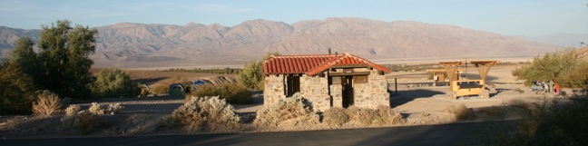
Texas Spring Campground | 92 sites | open mid October – mid April | $16 per night | first-come first-served | potable water, picnic tables, fire pits, flush toilets, and a dump station | elevation sea level
Stovepipe Wells Campground | 190 sites | open mid September – mid May | $14 per night | first-come first-served | potable water, some picnic tables, some fire pits, flush toilets, and a dump station | elevation sea level
Emigrant Campground | 10 tent only sites | open year round | no fee | first-come first-served | potable water, picnic tables, and flush toilets | elevation 2100 feet
Mesquite Springs Campground | 30 sites | open year round | $14 per night | first-come first-served | potable water, picnic tables, fire pits, flush toilets, and a dump station | elevation 1800 feet
Furnace Creek Campground | 136 sites | open year round | Reservations accepted October 15 – April 15 | $22-36 per night | potable water, picnic tables, fire pits, flush toilets, RV hookups, and a dump station | elevation 196 feet below sea level
For additional up-to-date information, visit the Death Valley National Park Camping Page.
Use the map below to view the campgrounds and get directions:
Or view California Desert trails and campgrounds in a larger map
Hikes in Death Valley National Park
| Trail | Description | Distance | Location |
|---|---|---|---|
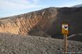 110 110 | Ubehebe Crater You can get a great view of Ubehebe Crater from an overlook near the parking lot, and there are also three trails to choose from. | 0 - 2 miles 0 - 275 feet | 37.0108, -117.4549 |
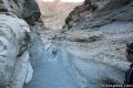 120 120 | Mosaic Canyon This out and back hike starts up a smooth marble slot canyon and exposes visitors to unique Death Valley geology. | 1 - 4 miles 100 - 750 feet | 36.57193, -117.14434 |
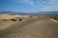 130 130 | Mesquite Flat Sand Dunes This hike explores the most visible sand dunes in Death Valley | 1 - 3 miles 100 feet | 36.6062, -117.1150 |
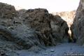 140 140 | Grotto Canyon This out and back hike requires a bit of climbing and is a lesser-visited trail in Death Valley. | 2 - 4 miles 625 feet | 36.5823, -117.1041 |
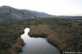 150 150 | Salt Creek This easy out and back hike crosses a short boardwalk bordering a rare desert stream. | 1 mile 25 feet | 36.5906, -116.9906 |
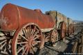 160 160 | Harmony Borax This short walk around the Harmony Borax plant offers a window into the mining past of Death Valley. | 0.25 miles 25 feet | 36.48003, -116.87335 |
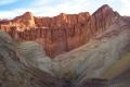 170 170 | Golden Canyon - Gower Gulch Loop This loop visits some of the most stunning terrain in Death Valley. | 4 miles 675 feet | 36.4207, -116.8467 |
 180 180 | Badlands Loop This loop offers a great immersion into the terrain beneath Zabriskie Point. | 2.5 miles 300 feet | 36.42085, -116.8099 |
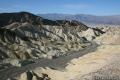 190 190 | Zabriskie Point Zabriskie Point offers a stunning panorama of the badlands near Furnace Creek. | 0.25 miles | 36.42085, -116.8099 |
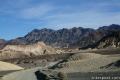 200 200 | Twenty Mule Team Canyon This 2.8-mile one way road lets visitors experience a fine canyon right from the driver’s seat. | 0 miles | 36.40953, -116.7947 |
 210 210 | Artist’s Drive This 9-mile drive crosses a sloping mountainside composed of vibrant soil colored by rich metals. | 0 - 0.5 miles | 36.32995, -116.82995 |
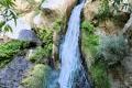 220 220 | Darwin Falls This out and back hike visits a refreshing year-round waterfall on the western edge of Death Valley. | 2 miles 275 feet | 36.32776, -117.51466 |
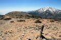 230 230 | Wildrose Peak This out and back hike summits a 9,064-foot peak in the Panamint Mountain Range on the west side of Death Valley. | 8.4 miles 2,200 feet | 36.2467, -117.0763 |
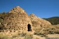 240 240 | Charcoal Kilns These conical constructions converted lumber to charcoal for area miners from 1879 to 1882. | 0 - 0.5 miles | 36.2467, -117.0763 |
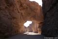 250 250 | Natural Bridge Canyon This is a great out and back hike for those interested in learning about the geological history of Death Valley. | 2 miles 400 feet | 36.28115, -116.7699 |
 260 260 | Badwater Basin This is the lowest place in North America -- a required stop for first time visitors to Death Valley. | 0 - 1 miles | 36.2301, -116.7671 |
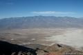 270 270 | Dante’s View This towering overlook above Badwater Basin offers panoramic views of Death Valley. | 0 - 1 miles 0 - 200 feet | 36.2206, -116.7266 |
 280 280 | Sidewinder Canyon This out and back hike visits narrow slot canyons full of pour-overs, carve outs, and dark passages that beg to be explored. | 4 - 7 miles 500 - 750 feet | 36.0650, -116.7448 |
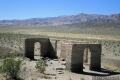 290 290 | Ashford Mill These ruins, where gold was once processed for the Ashford Mine, provide an example of how tough life can be in this harsh desert. | 0.1 miles | 35.9209, -116.6813 |
 | Mojave National Preserve There are a few campgrounds and endless roadside camping within the preserve. |
 | Joshua Tree National Park Nine campgrounds with 500 total sites are spread throughout the park to facilitate your visit. |
 | Anza-Borrego Desert State Park The biggest state park in California has four developed campgrounds, eight primitive campgrounds, and as much roadside camping as you could ever want. |

13 Comments on Camping in Death Valley National Park
What hikers are saying:
✨ Generated summary of user commentsCampers find that holiday weekends like Thanksgiving and New Year's bring large crowds that fill popular spots like Furnace Creek and Texas Spring. To escape the intense heat found at lower elevations during warmer months, seek out higher ground for a more comfortable stay. Winter visits offer mild daytime temperatures, though nights become chilly once the sun sets.
“Wildrose Campground is good for tent camping.” Jump to comment ↓
Does Texas Spring campground fill up on weekends this time of year?
It is probably too hot to be full after Memorial Day.
Is January a good time to camp in death valley
Certainly. It will probably be chilly an night, but nice and mild during the day.
Do the campsites fill up quickly this time of year (April 4th to 9th)? Where are good places to camp with a tent away from RVs? Thank you.
The campsites shouldn’t be full, but they will be hot. You may be happier in the higher elevation. Wildrose Campground is good for tent camping.
With the 2016 super bloom, will campgrounds still be closing April 1? Which ones accept 13′ trailers?
Is Spring Break a nice time to camp? Do we need 3 or 4 season tents and what’s the nicest for tents?
Is Thanksgiving weekend a busy time of year for campin in Death Valley?
Thanksgiving and New Years can be quite busy in Death Valley and Joshua Tree. Furnace Creek and Texas Spring are likely to fill, leaving you to choose from a campsite with less amenities. Have a great trip!
going in April
[…] Valley, especially Stovepipe and Emigrant, both of which Rob mentions specifically, check out the Hikes Peak website (which will give you good info) and the Death Valley National Park website, which will tell you […]
[…] Valley, especially Stovepipe and Emigrant, both of which Rob mentions specifically, check out the Hikes Peak website (which will give you good info) and the Death Valley National Park website, which will tell you […]