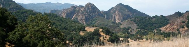
South Grassland Trail enters Malibu Creek State Park from Mulholland Highway, providing a scenic stroll over rolling hills. The trail ends at Crags Road, the major hiking artery through the park. If you are familiar with hiking out of the main parking lot, starting on the Grassland Trail adds about 0.9 miles to those hikes. By entering on Grassland Trail, visitors also avoid driving into the park and paying the vehicle entry fee. For a pleasant 3-mile hike through Malibu Creek State Park with just 125 feet of elevation gain, consider this lollipop loop from South Grassland Trail to Rock Pool.
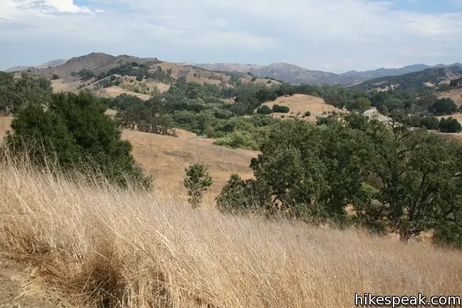
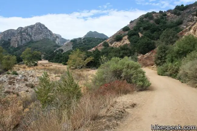
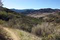
The gradual undulating fire road heads south through open fields of grain, gaining 100 feet of elevation, or just enough to offer far-stretching views of the Santa Monica Mountains.
The basic directions to Rock Pool from South Grassland Trail are:
- Begin down South Grassland Trail from Mulholland Highway (0 miles)
- At the end of the trail, turn right on Crags Road (0.66 miles)
- A split, bear right to proceed on High Trail (0.73 miles)
- Come to a junction where High Trail rejoins Crags Road and turn left (1.33 miles)
- Before crossing a bridge over Malibu Creek, turn right up the trail to Rock Pool (1.35 miles)
- Reach the shore of Rock Pool (1.55 miles)
- Backtrack to Crags Road and turn right (1.75 miles)
- Cross a bridge over Malibu Creek, pass the ranger station, make a pair of lefts, and cross Malibu Creek to return to the original split with High Road – turn right on Crags Road (2.27 miles)
- Turn left up South Grassland Trail (2.33 miles)
- Return to the trailhead on Mulholland Highway (3 miles)
South Grassland Trail to Rock Pool
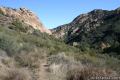
Set out from Mulholland Highway down South Grassland Trail. This trail begins from the south side of the road across from North Grassland Trail, which leads to Talepop Loop. South Grassland Grail crosses a short grassy rise with sweeping views of the mountains in Malibu Creek State Park.
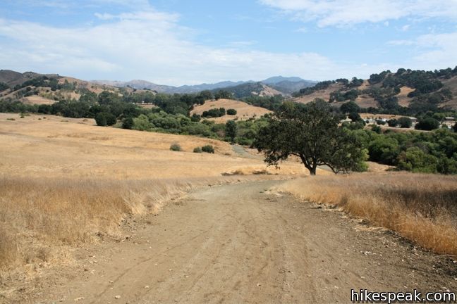
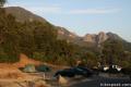
After 2/3 of a mile, Grassland Trail drops to Crags Road and comes to an end. To the left, it is 0.2 miles back to the large parking area near the park entrance. This is the more common and more expensive trailhead for hikes to Rock Pool and elsewhere. In the other direction, Crags Road heads deeper into Malibu Creek State Park.
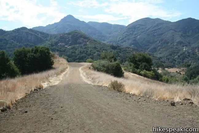
Turn right at the bottom of Grassland Trail, heading northwest on Crags Road. You will quickly reach a split where Crags Trail drops to the left across Malibu Creek while Crags Road continues straight ahead. This is the start of the loop in the hike outlined here. While there’s no reason you couldn’t turn left, these directions will lead you to stay to the right on High Trail.
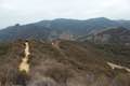
Follow High Trail to stroll along a level creek-side fire road that is shades by overhanging oaks. Malibu Creek dries out completely in the fall, but the views of the mountain range remain pleasant year round.
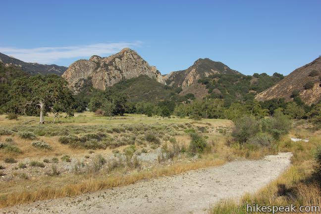
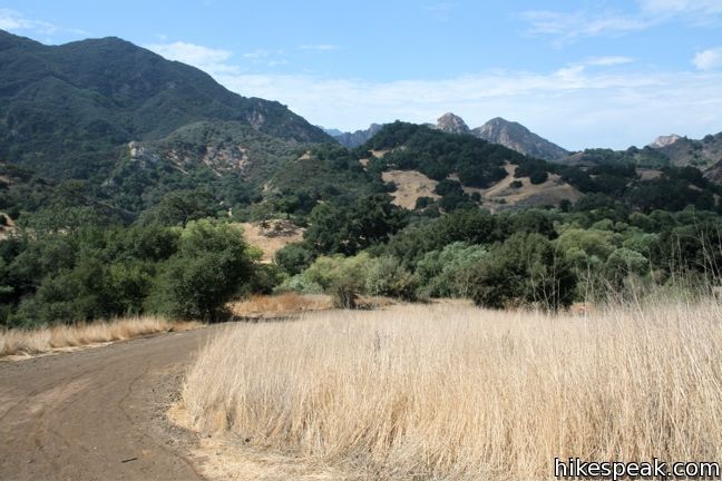
At 1 1/3 miles from the start of the hike, come to a signed junction which High Road and Crags Trail reunite. Straight ahead, Crags Road continues toward Century Lake and the old MASH set.
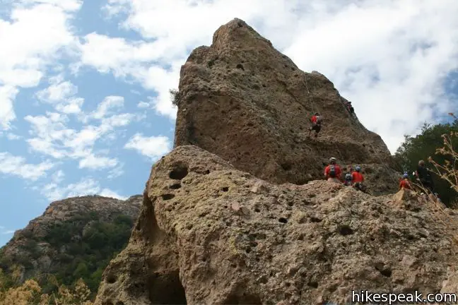
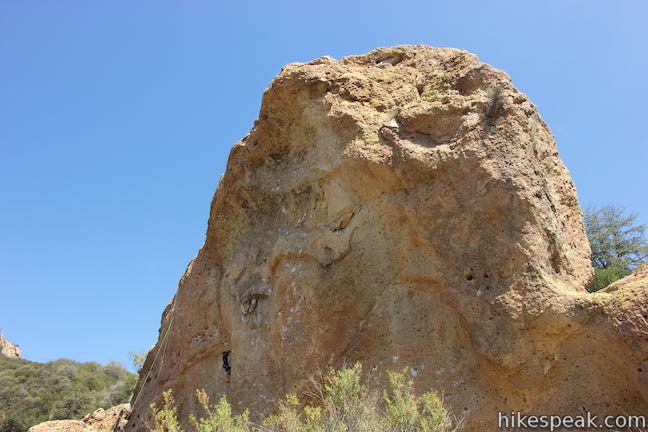
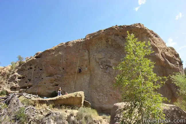
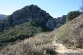
For Rock Pool, turn left in the direction of the visitor center. Just before reaching a bridge that crosses Malibu Creek, make a right on another wide trail. After a short distance, this trail turns to the right, but you should continue straight ahead on the unmarked but well-worn path to Rock Pool. The path follows the creek that flows out the bottom of Rock Pool, passing a popular climbing rock called Planet of the Apes Wall (because Planet of the Apes was filmed here). The sound of delighted children splashing around the inviting waters will likely guide your ears over the last 0.2 miles to Rock Pool.
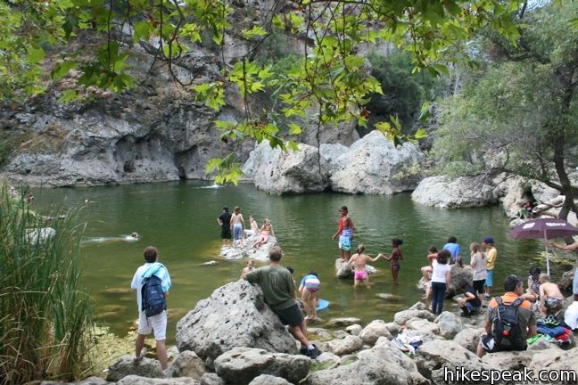
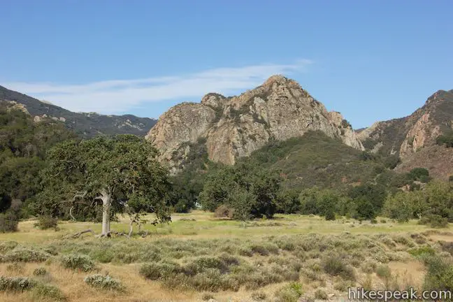
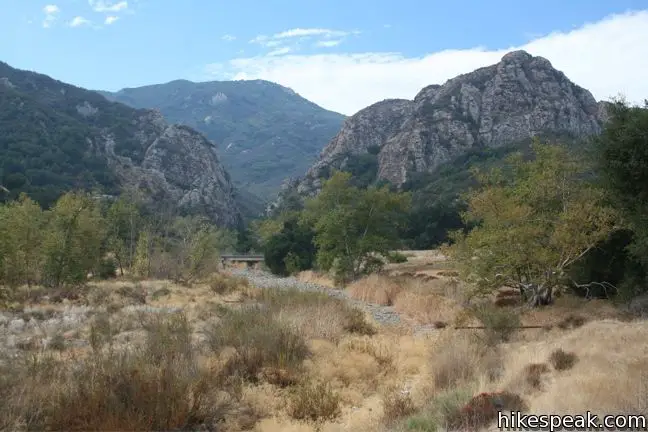
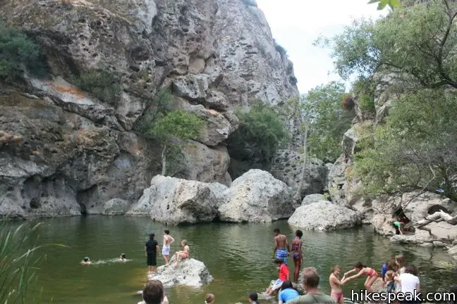
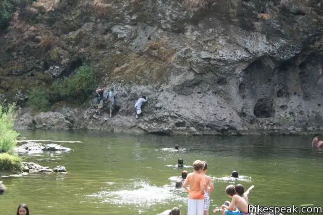
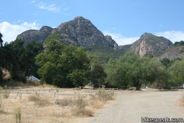
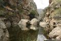
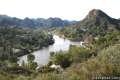
Rock Pool is situated at the outlet of a picturesque gorge. Sycamores and bays provide excellent shade and make this a perfect spot to have a picnic and relax by the reflective waters. Despite its name, you may see some people cliff jumping into Rock Pool. The LA Times warns that rangers may issue tickets to those who do so. Upstream lies a steep gorge with porous rock walls that make it a playground for rock climbers and adventurous hikers. If you are in the mode for a challenging trek that traverses the gorge between Rock Pool and Century Lake, or just want to see photos of cliff jumping into Rock Pool, read more here.
To get back to Grassland Trail, you may return the way you came or explore the other piece of Crags Road. This will add a loop to the middle of the hike. Returning to Crags Road from Rock Pool, turn right and cross over the Malibu Creek Bridge, which offers a great view toward the gorge above Rock Pool. Pass the visitor center on the other side and then cross a level field, bearing right at two splits to come to a path crossing Malibu Creek that leads back to the original Crags Trail – High Road Junction. Malibu Creek may be completely dry or running high with water. Rock hopping is required in the spring, but the creek dries out completely during the fall, despite being the largest watershed in the Santa Monica Mountains.
Turn right on Crags Road and walk a short distance back to Grassland Trail. Turn left. In this direction, the bottom of Grassland Trail is somewhat steep, but things tapers out as the trail crosses scenic grasslands and descends to Mulholland Highway.
This level 3-mile loop offers a great introduction to Malibu Creek State Park. Bikes are allowed on trails in Malibu Creek State Park, but dogs are not (the final trail to Rock Pool is too rough for bikes). No fee or permit is required to hike in on the Grassland Trail, so get out and enjoy.
On the north side of Mulholland Highway, Grassland Trail continues, offering another popular hike, Talepop Loop.
Woolsey Fire Update: This hike and most of Malibu Creek State Park have reopened following the November 2018 Woolsey Fire, which burned through the park. Check the Malibu Creek State Park page for more information.
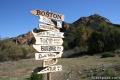
Directions to the Trailhead
- Take Las Virgenes/Malibu Canyon Road to the intersection with Mulholland Highway, 6.3 miles from the coast and 3.3 miles from the 101 Freeway in Lost Hills.
- Turn west at the light on Mulhollad Highway and drive 0.15 mile to the trailhead on the left.
- Street parking can be found on both sides of the road.
Trailhead Location
Trailhead address: 27000 Mulholland Highway, Agoura Hills, CA 91301
Trailhead coordinates: 34.10345, -118.7140 (34° 06′ 12.4″N 118° 42′ 50.4″W)
View Santa Monica Mountains in a larger map
Or view a regional map of surrounding Los Angeles trails and campgrounds.


 | Talepop Loop This 4.75-mile hike climbs 500 feet over a scenic mountain between Liberty Canyon and Las Virgenes Canyon. |
 | Las Virgenes View Trail This 4.95-mile hike patiently weaves its way across hills along Las Virgenes Road and rises up a canyon to ridgetop views over Malibu Creek State Park and mountains in Calabasas. |
 | Phantom Trail This 4.8-mile round trip hike crosses a panoramic ridge on the north side of Malibu Creek State Park. |
 | Cistern, Lookout, and Cage Creek Trails This team of single tracks make a scenic descent to Century Lake in Malibu Creek State Park, providing a short loop or longer hikes to other destinations. |
 | Malibu Creek Traverse This adventure hike explores the C-shaped gorge between Rock Pool and Century Lake in Malibu Creek State Park. |
 | M*A*S*H Set This hike visits the site where the exteriors of the television show MASH were filmed, a 4.75-mile trek from the park entrance. |
 | Lost Cabin Trail This 1.5-mile round trip extension to the MASH set hike dead-ends in a mountain canyon at the site of a now nonexistent cabin. |
 | Lake Vista Trail This 4.1-mile hike crosses the west end of Malibu Creek State Park and climbs to a scenic view over Malibu Lake. |
 | More trails in the Santa Monica Mountains Explore other destinations in the range. |
 | Malibu Creek State Park The year-round campground has 63 sites with picnic tables, fire rings, flush toilets, coin showers, and a dump station. |
Common Questions about Grassland Trail to Crags Road and Rock Pool in Malibu Creek State Park
- Is the trail open?
- Yes. You should expect to find that Grassland Trail to Rock Pool is open. There are no recent reports of trail closures. If you discover that the trail is closed, please help your fellow hikers by reporting a closure.
- Is this trail free to access?
- Yes, Grassland Trail to Rock Pool is free to access. No entrance fee, pass, or permit is required. If you discover that access rules have changed, please provide feedback on your experience.
- How much time does this hike take?
- It takes approximately 1 hour 15 minutes to hike Grassland Trail to Rock Pool. Individual hiking times vary. Add extra time for breaks and taking in the views.
- How long is this hike?
- The hike to Grassland Trail to Rock Pool is a 3 mile out and back with 125 feet of elevation change.
- Are dogs allowed on this trail?
- No, dogs are likely not allowed on Grassland Trail to Rock Pool. The trail is primarily open to hikers, bikes.
- What mountain range is this trail in?
- Grassland Trail to Rock Pool is located in the Santa Monica Mountains.
- Where is the trailhead located?
- The trailhead for Grassland Trail to Rock Pool is located in Agoura Hills, CA.
Trailhead Address:
27000 Mulholland Highway
Agoura Hills, CA 91301
Trailhead Coordinates:
34.10345, -118.714 - What are the driving directions to the start of the hike?
To get to the trailhead: Take Las Virgenes/Malibu Canyon Road to the intersection with Mulholland Highway, 6.3 miles from the coast and 3.3 miles from the 101 Freeway in Lost Hills. Turn west at the light on Mulhollad Highway and drive 0.15 mile to the trailhead on the left. Street parking can be found on both sides of the road.
View custom Google Maps directions from your current location.
- Are there other trails near Grassland Trail to Rock Pool?
- Yes, you can find other nearby hikes using the Hikespeak Hike Finder Map.

Can you help me figure out distance? Feeling incompetent at this one :). Today we did Grassland Trail to MASH site, on our return we did the Lookout Trail (which I believe first took us on Cage Trail), we came of Lookout trail at the other side (it’s a loop with two entrances as I’m sure you know). Then we returned to where we began. Thanks in advance!
[…] BEACH RD, SANTA MONICA, CA 90402 CULVER CITY PLUNGE 4175 OVERLAND AVENUE, CULVER CITY, CA 90230 MALIBU CREEK STATE PARK ROCK POOL 1925 LAS VIRGENES ROAD, AGOURA HILLS, CA 91301 THE STANDARD DOWNTOWN 550 S FLOWER ST, LOS ANGELES, […]