McAuley Peak 2049 Backbone Trail Piuma Trailhead Mesa Peak Motorway Milt McAuley hike Malibu California
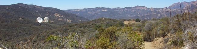
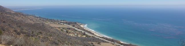
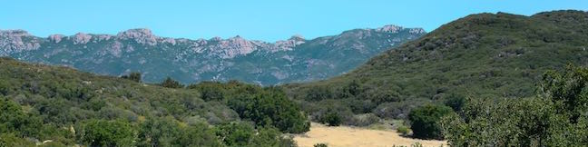
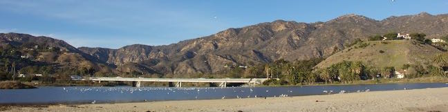
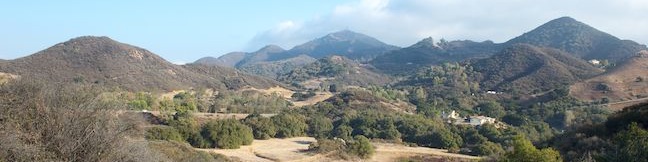
Existing without an official name until 2015, McAuley Peak was already a convenient destination along the Backbone Trail, hosting a distinct rock formation and panoramic views over the surrounding Santa Monica Mountains. The name - honoring conservationist, author, and literal trailblazer Milt McAuley - adds even more heft to the peak. This hike to the 2,049-foot crown of McAuley Peak begins from the Piuma Trailhead in Malibu Creek State Park. ...Read more.
My Hikes: Completed hikeA green icon of shows a picture of a landscape with a check mark in the upper right corner, signifying that this is a hike you would like to put on your completed list.OK! Add to trails I've hiked
My Hikes: Want to hikeA green icon of shows a picture of a landscape with a heart in the upper right corner, signifying that this is a hike you would like to put on your to-do list.OK! Add to trails I want to hike
TagsA green icon depicting a tags represents a list of words and phrases that this content is tagged with Tagged with · Backbone Trail · California State Parks · Malibu · Ocean Views · Summits · Malibu Creek State Park · Mountain Biking Trails · Santa Monica Mountains
Hike DistanceA green icon of a hiker used to label information about the length of the hike Distance: 6.15 miles · Elevation change: 1530 feet
By: Published: Last updated: December 9, 2025
Phantom Trail Malibu Creek State Park Agoura Hills California
The beautiful Santa Monica Mountains can be a busy place to hike. One trail you can take to feel like a ghost (not see any other hikers) is Phantom Trail. Located on the north side of Malibu Creek State Park, this scarcely visited single track is not as popular as neighboring trails, but you'll be dumbfounded as to why when Phantom Trail provides early panoramas over the rest of the picturesque park. ...Read more.
My Hikes: Completed hikeA green icon of shows a picture of a landscape with a check mark in the upper right corner, signifying that this is a hike you would like to put on your completed list.OK! Add to trails I've hiked
My Hikes: Want to hikeA green icon of shows a picture of a landscape with a heart in the upper right corner, signifying that this is a hike you would like to put on your to-do list.OK! Add to trails I want to hike
TagsA green icon depicting a tags represents a list of words and phrases that this content is tagged with Tagged with · Agoura Hills · California State Parks · Free Trails · Malibu · Malibu Creek State Park · Santa Monica Mountains
Hike DistanceA green icon of a hiker used to label information about the length of the hike Distance: 4.8 miles · Elevation change: 1175 feet
By: Published: Last updated: December 5, 2025
Arroyo Sequit Park Santa Monica Mountains National Recreation Area Arroyo Sequit Nature Trail
Take a trip to Arroyo Sequit Park to hike a short loop through a tucked-away pocket of the Santa Monica Mountains, The park is situated along Mulholland Highway inland of Leo Carrillo State Park and below the range's most rugged peaks. The surroundings for this 2.05 miles hike are beautiful. Arroyo Sequit Nature Trail has 285 feet of elevation change, winding over and around the upper reaches of a canyon carved by the East Fork of Arroyo Sequit. ...Read more.
My Hikes: Completed hikeA green icon of shows a picture of a landscape with a check mark in the upper right corner, signifying that this is a hike you would like to put on your completed list.OK! Add to trails I've hiked
My Hikes: Want to hikeA green icon of shows a picture of a landscape with a heart in the upper right corner, signifying that this is a hike you would like to put on your to-do list.OK! Add to trails I want to hike
TagsA green icon depicting a tags represents a list of words and phrases that this content is tagged with Tagged with · Arroyo Sequit Park · Closed · Free Trails · Malibu · Santa Monica Mountains National Recreation Area · Wildflowers · Dog-Friendly Trails · Santa Monica Mountains
Hike DistanceA green icon of a hiker used to label information about the length of the hike Distance: 2.05 miles · Elevation change: 285 feet
By: Published: Last updated: December 6, 2025
Nicholas Flat Trail Willow Creek Trail Ocean Vista Hike Malibu Leo Carrillo State Park Scenic Loop hike Santa Monica Mountains
At the west end of Malibu where Mulholland Highway meets PCH, you'll find Leo Carrillo State Park. Well known for its beaches and surfing, this park has offerings for hikers too, like the trek up Nicholas Flat Trail to an oak-wrapped grassland with a small pond, which is 7 miles round trip or more. For a shorter hike, combine the bottom of Nicholas Flat Trail with Willow Creek Trail, for a 2. ...Read more.
My Hikes: Completed hikeA green icon of shows a picture of a landscape with a check mark in the upper right corner, signifying that this is a hike you would like to put on your completed list.OK! Add to trails I've hiked
My Hikes: Want to hikeA green icon of shows a picture of a landscape with a heart in the upper right corner, signifying that this is a hike you would like to put on your to-do list.OK! Add to trails I want to hike
TagsA green icon depicting a tags represents a list of words and phrases that this content is tagged with Tagged with · California State Parks · Leo Carrillo State Park · Malibu · Ocean Views · Santa Monica Mountains
Hike DistanceA green icon of a hiker used to label information about the length of the hike Distance: 2.05 miles · Elevation change: 620 feet
By: Published: Last updated: December 9, 2025
Nicholas Flat Trail Hike Malibu Leo Carrillo State Park Nicholas Flat Natural Preserve Santa Monica Mountains California
Nicholas Flat Trail is a three-mile long 'ocean to mountains' trail beginning within Leo Carrillo State Park, just across PCH from a famous beach at the west end of Malibu. The single-track trail travels up a coastal ridge past two vista points (and lots of other ocean views) to reach Nicholas Flat, where grassy meadows are rimmed by oak trees. A small network of trails offer different routes through Nicholas Flat Natural Preserve. ...Read more.
My Hikes: Completed hikeA green icon of shows a picture of a landscape with a check mark in the upper right corner, signifying that this is a hike you would like to put on your completed list.OK! Add to trails I've hiked
My Hikes: Want to hikeA green icon of shows a picture of a landscape with a heart in the upper right corner, signifying that this is a hike you would like to put on your to-do list.OK! Add to trails I want to hike
TagsA green icon depicting a tags represents a list of words and phrases that this content is tagged with Tagged with · California State Parks · Leo Carrillo State Park · Malibu · Nicholas Flat Natural Preserve · Ocean Views · Santa Monica Mountains
Hike DistanceA green icon of a hiker used to label information about the length of the hike Distance: 7 miles · Elevation change: 1685 feet
By: Published: Last updated: December 9, 2025
Malibu Lagoon State Beach Surfer's Express Trail Surfrider Beach Malibu Pier Malibu Creek Estuary Beach Walk Malibu California
Recently restored Malibu Lagoon State Beach is a lovely place to walk around an estuary and stroll along the beach. Take a walking path to overlooks around shorebird-filled wetlands and connect to Surfrider Beach, a world famous point break where Malibu Creek meets the Pacific Ocean. Sinking your toes in the sand, you can make your way east to Malibu Pier. ...Read more.
My Hikes: Completed hikeA green icon of shows a picture of a landscape with a check mark in the upper right corner, signifying that this is a hike you would like to put on your completed list.OK! Add to trails I've hiked
My Hikes: Want to hikeA green icon of shows a picture of a landscape with a heart in the upper right corner, signifying that this is a hike you would like to put on your to-do list.OK! Add to trails I want to hike
TagsA green icon depicting a tags represents a list of words and phrases that this content is tagged with Tagged with · Beaches · California State Parks · Malibu · Malibu Lagoon State Beach · Wheelchair-Friendly
Hike DistanceA green icon of a hiker used to label information about the length of the hike Distance: 2 miles · Elevation change: 10 feet
By: Published: Last updated: December 5, 2025
Mesa Peak hike Backbone Trail Mesa Peak Motorway hike Corral Canyon Road ocean view summit Malibu California Corral Canyon Cave Jim Morrison Cave
It is pretty unusual to hike to a peak from a trailhead at a higher elevation. In the case of Mesa Peak, the lofty trailhead along Corral Canyon Road treats hikers to summit-worthy views right from the get-go. While the elevation profile is atypical, the hike along Mesa Peak Motorway to Mesa Peak in Malibu is quite enjoyable. Ocean overlooks appear all along the wide dirt road, which also passes some very impressive sandstone formations. ...Read more.
My Hikes: Completed hikeA green icon of shows a picture of a landscape with a check mark in the upper right corner, signifying that this is a hike you would like to put on your completed list.OK! Add to trails I've hiked
My Hikes: Want to hikeA green icon of shows a picture of a landscape with a heart in the upper right corner, signifying that this is a hike you would like to put on your to-do list.OK! Add to trails I want to hike
TagsA green icon depicting a tags represents a list of words and phrases that this content is tagged with Tagged with · Backbone Trail · Malibu · Ocean Views · Santa Monica Mountains National Recreation Area · Summits · Malibu Creek State Park · Mountain Biking Trails · Santa Monica Mountains
Hike DistanceA green icon of a hiker used to label information about the length of the hike Distance: 6.5 miles · Elevation change: 465 feet
By: Published: Last updated: December 5, 2025
Rocky Oaks Park hike Santa Monica Mountains National Recreation Area Pond Trail Rocky Oaks Loop Trail Malibu California hiking
Good things do come in small packages, like Rocky Oaks, one of the tinier parcels in the Santa Monica Mountains National Recreation Area. The park covers less than 200 acres, but a collection of interwoven trails allow visitors to hike about 2 miles in this park. For a short and level half-mile loop, stroll around a seasonal pond that was used as a cattle pond when Rocky Oaks was a ranch. ...Read more.
My Hikes: Completed hikeA green icon of shows a picture of a landscape with a check mark in the upper right corner, signifying that this is a hike you would like to put on your completed list.OK! Add to trails I've hiked
My Hikes: Want to hikeA green icon of shows a picture of a landscape with a heart in the upper right corner, signifying that this is a hike you would like to put on your to-do list.OK! Add to trails I want to hike
TagsA green icon depicting a tags represents a list of words and phrases that this content is tagged with Tagged with · Free Trails · Malibu · Santa Monica Mountains National Recreation Area · Dog-Friendly Trails · Mountain Biking Trails · Santa Monica Mountains
Hike DistanceA green icon of a hiker used to label information about the length of the hike Distance: 2 miles · Elevation change: 175 feet
By: Published: Last updated: December 5, 2025
Malibu Springs Trail to Nicholas Flat Malibu California hike Santa Monica Mountains Leo Carrillo State Park Mulholland Highway hike to Nicholas Flat Natural Preserve
Near the west end of Mulholland Highway north of Leo Carrillo State Park, you will find an almost hidden trailhead for Malibu Springs Trail. This spring-loaded single track is faint and overgrown in areas, providing a sense of adventure as you take in fantastic views of the highest peaks Santa Monica Mountains. At the end of an arduous climb, you will drop down to Nicholas Flat in Nicholas Flat Natural Preserve. ...Read more.
My Hikes: Completed hikeA green icon of shows a picture of a landscape with a check mark in the upper right corner, signifying that this is a hike you would like to put on your completed list.OK! Add to trails I've hiked
My Hikes: Want to hikeA green icon of shows a picture of a landscape with a heart in the upper right corner, signifying that this is a hike you would like to put on your to-do list.OK! Add to trails I want to hike
TagsA green icon depicting a tags represents a list of words and phrases that this content is tagged with Tagged with · California State Parks · Free Trails · Leo Carrillo State Park · Malibu · Nicholas Flat Natural Preserve · Ocean Views · Wildflowers · Santa Monica Mountains
Hike DistanceA green icon of a hiker used to label information about the length of the hike Distance: 7 miles · Elevation change: 1425 feet
By: Published: Last updated: December 5, 2025
Mesa Peak hike Backbone Trail Piuma Trailhead Malibu Creek State Park hike Tapia Park ocean view summit Malibu California
A mesa is defined as a flat-topped hill with steep sides. A peak is defined as the pointed top of a mountain. Put these contradictions together and you get a subtle summit with substantial ocean views. This short perch on a mesa-like ridge behind Pepperdine University in Malibu delivers panoramic views over the surrounding Santa Monica Mountains. The hike to Mesa Peak up the steep sides of the mesa begins from the Piuma Trailhead in Malibu Creek State Park and follows 2. ...Read more.
My Hikes: Completed hikeA green icon of shows a picture of a landscape with a check mark in the upper right corner, signifying that this is a hike you would like to put on your completed list.OK! Add to trails I've hiked
My Hikes: Want to hikeA green icon of shows a picture of a landscape with a heart in the upper right corner, signifying that this is a hike you would like to put on your to-do list.OK! Add to trails I want to hike
TagsA green icon depicting a tags represents a list of words and phrases that this content is tagged with Tagged with · Backbone Trail · California State Parks · Malibu · Ocean Views · Summits · Malibu Creek State Park · Santa Monica Mountains
Hike DistanceA green icon of a hiker used to label information about the length of the hike Distance: 6.5 miles · Elevation change: 1375 feet
By: Published: Last updated: December 9, 2025

Tag!

You've come to a tag page, one of the blogiest ways to browse hikespeak.com.

Here are some more tags. The most common tags are the big ones at the top of the list. Have a look around. You may also find what you seek with the search feature on the Hike Finder Map.

Free TrailsNational ParksOcean ViewsCalifornia State ParksSummitsWaterfallsTent CampingCreeksLakesNature TrailsAngeles National ForestMalibuAdventure PassCascade RangeNew Zealand Department of ConservationDesert CanyonsOff TrailWildflowersBeachesLos Padres National ForestNew Zealand National ParksMountains Recreation and Conservation AuthoritySan Gabriel Mountains National MonumentGriffith ParkBig SurWheelchair-FriendlyCampervan CampingRuinsSequoia GrovesOregon State ParksLos OsosPacific Crest TrailHydrothermalCavesHollywoodBackpackingMontaña de Oro State ParkAustralian National ParksTopanga State ParkYosemite ValleyRedwood GrovesAltadenaSanta Ynez MountainsSanta Monica Mountains National Recreation AreaTopangaIrish HillsLone PineMalibu Creek State ParkBorrego SpringsAgoura HillsTrail CampArchesBureau of Land ManagementLookout TowersPacific PalisadesBoulderingDeschutes National ForestColumbia River Gorge National Scenic AreaBackbone TrailLavaWest Hills of PortlandMorrosTualatin MountainsArthur's Pass VillageMinesNevada State ParksTongariro National ParkMammoth LakesWalk-in CampingFruitaGrand JunctionArthur's Pass National ParkBendGiant ForestLa Cañada FlintridgeTide PoolsMorro BayCleveland National ForestRotoruaAzusaJohn Muir TrailAccommodationsOvertonArcadiaPasadenaZion CanyonLava TubesGoletaIsland in the SkyCalabasasTasmania's 60 Great Short WalksHot SpringsSanta Lucia MountainsClaremontGaviota State ParkBadlandsVerdugo MountainsBoardwalksGolden Trout WildernessClosedTillamookPhillip IslandAoraki Mount Cook National ParkRainforestsShasta-Trinity National ForestClosed SeasonallyVolcanoesNorthwest PortlandLas VegasSan Bernardino National ForestGrand Canyon of the YellowstoneForest ParkMount CookVolcanoNewbury ParkPetroglyphsGrant GroveGeyser BasinsStairsButtesBrentwoodGifford Pinchot National ForestFreycinet PeninsulaSan Ysidro MountainsColes BayMorro Bay State ParkTopatopa MountainsThousand OaksPalos Verdes PeninsulaSand DunesOakhurstOnondaga CountyAdirondack ParkAdirondack MountainsMorterosGiant Sequoia National MonumentAnsel Adams WildernessOhakuneOjaiMemorialsFreycinet National ParkLighthousesJohn Muir WildernessTasman PeninsulaTrabuco Ranger DistrictSan Bernardino MountainsWestern DivideSanta Ana MountainsSilver Moccasin TrailOrange County ParksPoint Mugu State ParkWestridge-Canyonback Wilderness ParkPaicinesSunriverWestern Divide Ranger DistrictNatural BridgesWill Rogers State ParkCratersNelder GroveTopanga CanyonStevensonWhakapapa VillageLava Butte Lava FlowWashington State ParksMount Hood National ForestCastle Crags State ParkMount ShastaThree Capes Scenic RouteNewberry National Volcanic MonumentWater SlidesMount HoodTarzanaContinental DivideSouth Lake TahoeSistersHobartReservoir Canyon Natural ReserveDomesPfeiffer Big Sur State ParkHumboldt Redwoods State ParkSouthwest PortlandOasesLeo Carrillo State ParkMoabGovernment CampNewhallLaguna BeachJulianSouth Coast WildernessTemescal Gateway ParkSilver Falls State ParkCambriaHutsSublimityGlacier LakesCliff JumpingGoing-to-the-Sun RoadPearblossomMontecitoHawaii State ParksKlamath MountainsSpringvilleRancho Palos VerdesWawonaDeschutes RiverCamp ShermanWildlife ViewingBeacon Rock State ParkLos Robles Open SpaceTanksYellowstone RiverSan Vicente Mountain ParkSwimming HolesObservatoriesIdyllwildSan Jacinto Ranger DistrictWaiotapuBurbankPalomar Ranger DistrictCalifornia Coastal TrailTasman National ParkLabrador Hollow Unique AreaCortland CountyTullyNew York State ForestsMount William National ParkVestalPicnic AreaWind CavesSan Jacinto MountainsSilver Peak WildernessBinghamton University Nature PreserveCedar GroveBlack HillsAvila BeachJulia Pfeiffer Burns State ParkCinder ConesLake ElsinoreMurrietaWenatche National ForestElephant SealsGlendaleSnowshoeingSan Mateo Canyon WildernessWilsons Promontory National ParkCrestlineEmma Wood State BeachWhananaki NorthCarpinteriaPlacerita Canyon Natural AreaPlacerita Canyon State ParkBike TrailSan PedroTujungaSanta Susana MountainsNew York State ParksSun ValleyCrescent CityRedwood Mountain GroveBishop Peak Natural ReserveAvila ValleySimi HillsSheep Mountain WildernessCrystal Cove State ParkSierra Pelona MountainsSanta MargaritaBeverly HillsConejo ValleyBlue Mountain LakeNicholas Flat Natural PreserveHume Lake Ranger DistrictGlaciersTe AwamutuRangitikeiSummit ValleySummit Valley Edmund D. Edelman ParkFish HatcheryWoodland HillsCastle Crags WildernessPepperwoodTryon Creek State Natural AreaTaurangaTaupoLodgeSanta PaulaTwentynine PalmsSherman OaksWillamette National ForestSouthern AlpsPortlandMount Thomas Forest Conservation AreaOkukuCusterCal PolyMacleay ParkWaimangu Volcanic ValleyPictographsOkere Falls Scenic ReserveOkere FallsArroyo GrandeMarvin Braude Mulholland Gateway ParkHood RiverEaglehawk NeckCampervan ReviewMount WellingtonWellington ParkTree MoldsLauncestonWaipio ValleyAndrew Molera State ParkCatalina IslandLimekiln State ParkHiloMount Field National ParkBritzRichardson Grove Redwoods State ParkColumbia River GorgeLake Tahoe Basin National Forest LandsPuakoCampervan RentalRocky MountainsLyleSaltwater RiverDeschutes River State Recreation AreaBlowholesWascoLord of the RingsBoat CruiseHarmony Headlands State ParkCayucosSanta Clarita Woodlands ParkAgua DulceCrazy Horse MemorialMonrovia Canyon ParkMonroviaRefugio State BeachPrimitive CampingSatellite CommunicatorsSOS BeaconsMount MaunganuiCulver CityHigh LineMatamataMount San Jacinto State ParkSan Jacinto WildernessMuruparaBanningFiscalini Ranch PreserveKings CanyonWhitewater RaftingTop 10 Holiday ParkPapamoaAerial GreenwayManhattanGPS NavigatorsPalomar MountainsAmboy Crater National Natural LandmarkPetrified LogsPowell Butte Nature ParkSoutheast PortlandBig Bear LakeCross Country SkiingCarpinteria Salt Marsh Nature ParkSonoraCarpinteria Bluffs Nature PreserveLas CrucesVentura RiverPilot Butte State ParkOak ParkMount Lowe RailwayLaguna Coast Wilderness ParkWarner SpringsOrangePeters Canyon Regional ParkSanta Lucia WildernessCarpinteria Seal SanctuaryGetty View ParkHearst San Simeon State ParkMalibu Lagoon State BeachKura Tawhiti / Castle Hill Conservation AreaCastle HillCentral ParkHuntington BeachAwbrey ButteHobbitonLiffeyFallbrookBerriedaleVasquez Rocks Natural Area ParkJamesvilleClark Reservation State ParkBeaver Lake Nature CenterBaldwinsvilleOnondaga County ParkWhitewater PreserveDocent-led HikesPlaya VistaAnaheimCataract Gorge ReserveSan SimeonTauwhara BayLiffey Falls State ReserveGreat Western TiersCape Woolamai State Faunal ReserveKoalasSaint Columba Falls State ReservePyenganaFallbrook Land ConservancyHokianga HarbourDouglas-Apsley National ParkBechinoOtamure BayOtamure Recreation ReserveYucca ValleySan Rafael HillsApp ReviewGuy W. Talbot State ParkEugeneMission Trails Regional ParkTurangiSanteeSanta Rosa and San Jacinto Mountains National MonumentGreen Lakes State ParkFayettevilleConcretionsMangawekaHuntervilleBel AirNewport BeachNewport BayJedediah Smith Redwoods State ParkSantiago Oaks Regional ParkMacKerricher State ParkSalt Point State ParkWeir Canyon Wilderness ParkB&BEl Capitán State BeachFreeride TrailsWest HillsBackpackers LodgeUpper Newport Bay Nature PreserveLake Tikitapu Scenic ReserveMotor LodgeSespe WildernessMyers FlatKlamath National ForestSeasideBaldwin Hills Scenic Overlook State ParkLaCrosseLas Virgines View ParkPalouse Falls State ParkArcoEl Chorro Regional ParkOregon CityWillamette RiverHappy ValleyCamassia Natural AreaWest LinnMontagueWeedCorbettGeorge Himes Nature ParkWeottOrickFort BraggJennerWhite SalmonCamasLacamas Lake Regional ParkPrairie Creek Redwoods State ParkMcKenzie BridgeDuartePalos Verdes EstatesThe Nature ConservancyLincoln CityDepoe BayCooke CityClatskanieGlenbrookCarson CityDevils TowerLake MichiganTuna Canyon ParkWelchesRhododendronOceansideNative American HeritageBass LakeStroller-FriendlyBisonDunsmuirSiletz Bay National Wildlife RefugeSanta ClaritaFishpondsKonaCastaicKohala Forest ReserveKenneth Hahn State Recreation AreaHonomuHollywood HillsStudio CityPu‘uhonua O Hōnaunau National Historical ParkHonaunauLongridge ParkYurtsBreaCape Meares State ParkArroyo Sequit ParkOceano Dunes State Vehicular Recreation AreaCape Lookout State ParkNipomoCannon BeachEldorado State ParkColorado State ParksBoulderMarquam Nature ParkShasta LakeCalaveras Big Trees State ParkMojave Trails National MonumentAtascaderoCape Kiwanda Natural AreaCucamonga WildernessPacific CityCarbon Canyon Regional ParkCape Meares State Scenic ViewpointEcola State ParkMosierSimi ValleyCanoe & KayakAdirondack High PeaksMonserate Mountain PreserveTumalo CreekMaricopaShevlin ParkKlamathPortervilleTualatin Hills Nature ParkBeavertonGarbervilleUpper Ojai ValleyArchie Briggs Natural AreaArboretumsPismo BeachAmboySan BernardinoSkyforestCascade LocksLake ArrowheadLake Placid