Josephine Peak Hike Colby Canyon Trail San Gabriel Mountains National Monument Angeles National Forest Josephine Saddle Josephine Peak Road
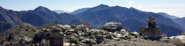
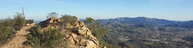
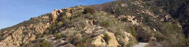
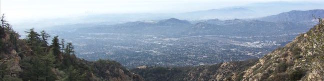
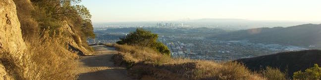
Want to hike to a mile-high summit in the San Gabriel Mountains with grand views over Los Angeles? Set your aim for Josephine Peak in the front range of the San Gabriel Mountains next to Strawberry Peak. Colby Canyon Trail offers a scenic route to the summit, traveling from Angeles Crest Highway up a withdrawn canyon to Josephine Saddle, a dip in the ridgeline west of Strawberry Peak. ... Read more.
My Hikes IconAn green hiker icon marks the links to add this hike to your my hikes lists OK! Add to trails I’ve hiked
OK! Add to trails I want to hike
TagsA green icon depicting a tags represents a list of words and phrases that this content is tagged with Tagged with · Altadena · Angeles National Forest · Free Trails · San Gabriel Mountains National Monument · Summits · Dog-Friendly Trails · San Gabriel Mountains
Hike DistanceA green icon of a hiker used to label information about the length of the hike Distance: 8.7 miles · Elevation change: 2050 feet
By: Published: Last updated: May 13, 2025
China Flat Trail Simi Peak Trail Simi Hills hike Oak Park California China Flat Dead Cow Trail Suicide Trail Loop Oak Savanna
Looking up at the orange sandstone outcroppings on the rugged slopes of the Simi Hills, you would hardly expect the terrain above to host a peaceful oak savanna. Walk through this grassy area shade by tall oaks to ascend to Simi Peak, the highest point in a mountain range that spans the boundary between Ventura County and Los Angeles County just north of the 101 Freeway. Simi Peak is 2,403... Read more.
My Hikes IconAn green hiker icon marks the links to add this hike to your my hikes lists OK! Add to trails I’ve hiked
OK! Add to trails I want to hike
TagsA green icon depicting a tags represents a list of words and phrases that this content is tagged with Tagged with · Conejo Valley · Free Trails · Oak Park · Simi Hills · Summits · Dog-Friendly Trails · Mountain Biking Trails
Hike DistanceA green icon of a hiker used to label information about the length of the hike Distance: 6.2 miles · Elevation change: 1090 feet
By: Published: Last updated: May 13, 2025
Mount Lowe Road Sunset Ridge Trail to Cape of Good Hope Mount Lowe Railway Echo Mountain Ruins San Gabriel Mountains Hike Los Angeles National Forest California
Starting near the base of the San Gabriel Mountains in Altadena, Mount Lowe Road is an 8.9-mile long partially paved trail rising up the range to an intersection with Mount Wilson Red Box Road near the summit of Mount Wilson. Of course, you don't have to go that full distance on a hike up Mount Lowe Road. Sunset Ridge Trail intersects and parallels the bottom of Mount Lowe Road and is even... Read more.
My Hikes IconAn green hiker icon marks the links to add this hike to your my hikes lists OK! Add to trails I’ve hiked
OK! Add to trails I want to hike
TagsA green icon depicting a tags represents a list of words and phrases that this content is tagged with Tagged with · Altadena · Angeles National Forest · Free Trails · Mount Lowe Railway · Pasadena · Ruins · Waterfalls · Dog-Friendly Trails · Los Angeles Waterfalls · San Gabriel Mountains
Hike DistanceA green icon of a hiker used to label information about the length of the hike Distance: 5.2 miles · Elevation change: 1425 feet
By: Published: Last updated: May 13, 2025
Castle Canyon Trail to Inspiration Point Echo Mountain Ruins Mount Lowe Road Mount Lowe Railway San Gabriel Mountains Hike Los Angeles National Forest California
Castle Canyon Trail is a dirt single track that connects the ruins at Echo Mountain to Inspiration Point, which was a premier vista point for the resort's visitors and still offers sweeping views. In the past, a railway took Echo Mountain's guests up into the mountains, but now leg power is required to get up Castle Canyon Trail to Inspiration Point. The single track is gradual when it... Read more.
My Hikes IconAn green hiker icon marks the links to add this hike to your my hikes lists OK! Add to trails I’ve hiked
OK! Add to trails I want to hike
TagsA green icon depicting a tags represents a list of words and phrases that this content is tagged with Tagged with · Altadena · Angeles National Forest · Free Trails · Pasadena · Trail Camp · Dog-Friendly Trails · San Gabriel Mountains
Hike DistanceA green icon of a hiker used to label information about the length of the hike Distance: 4 miles · Elevation change: 1325 feet
By: Published: Last updated: May 13, 2025
Las Flores Motorway hike Mount Thom Las Flores Motorway Trail Verdugo Mountains Glendale California Hike
Las Flores Motorway weaves its way up ridges on the southeast end of the Verdugo Mountains in Glendale. The wide dirt trail blooms when it reaches Mount Thom, a 2,460-foot summit with panoramic views over surrounding city-flanked mountain ranges and the skyline of downtown Los Angeles. Las Flores Motorway gains 1,220 feet in 2.5 miles to join Beaudry Motorway just below the summit. Strut... Read more.
My Hikes IconAn green hiker icon marks the links to add this hike to your my hikes lists OK! Add to trails I’ve hiked
OK! Add to trails I want to hike
TagsA green icon depicting a tags represents a list of words and phrases that this content is tagged with Tagged with · Free Trails · Glendale · Summits · Dog-Friendly Trails · Mountain Biking Trails · Verdugo Mountains
Hike DistanceA green icon of a hiker used to label information about the length of the hike Distance: 5.3 miles · Elevation change: 1260 feet
By: Published: Last updated: December 7, 2018