Mesa Peak hike Backbone Trail Piuma Trailhead Malibu Creek State Park hike Tapia Park ocean view summit Malibu California
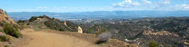
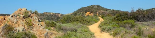
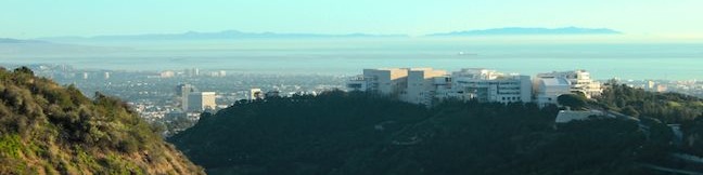
A mesa is defined as a flat-topped hill with steep sides. A peak is defined as the pointed top of a mountain. Put these contradictions together and you get a subtle summit with substantial ocean views. This short perch on a mesa-like ridge behind Pepperdine University in Malibu delivers panoramic views over the surrounding Santa Monica Mountains. The hike to Mesa Peak up the steep sides... Read more.
My Hikes IconAn green hiker icon marks the links to add this hike to your my hikes lists OK! Add to trails I’ve hiked
OK! Add to trails I want to hike
TagsA green icon depicting a tags represents a list of words and phrases that this content is tagged with Tagged with · Backbone Trail · California State Parks · Malibu · Ocean Views · Summits · Malibu Creek State Park · Santa Monica Mountains
Hike DistanceA green icon of a hiker used to label information about the length of the hike Distance: 6.5 miles · Elevation change: 1375 feet
By: Published: Last updated: May 13, 2025
Calabasas Peak hike trail Los Angeles Calabasas Cold Creek Trail Secret Trail hike Calabasas Peak Motorway
Before it was called Calabasas - Cold Creek Trail, this single track on the northwest side of Calabasas Peak was called the Secret Trail. Well the secret is out and this 4.5-mile round trip trek is a pleasure that all hikers should discover! Tackle 750 feet of elevation change as you cross ridges and ravines topped by sandstone minarets, eventually reaching a 2,163-foot summit with 360... Read more.
My Hikes IconAn green hiker icon marks the links to add this hike to your my hikes lists OK! Add to trails I’ve hiked
OK! Remove from my hikes
TagsA green icon depicting a tags represents a list of words and phrases that this content is tagged with Tagged with · Free Trails · Summits · Dog-Friendly Trails · Mountain Biking Trails · Santa Monica Mountains
Hike DistanceA green icon of a hiker used to label information about the length of the hike Distance: 4.5 miles · Elevation change: 750 feet
By: Published: Last updated: December 7, 2018
Mount Baden-Powell Trail San Gabriel Mountains hike Mt Baden Powell Summit hike Angeles National Forest Pacific Crest Trail
Mount Baden-Powell is a special summit in the San Gabriel Mountains. It is one of the range's tallest peaks at 9,399 feet and holds particular importance to the Boy Scouts of America because it memorializes the lofty accomplishments of Lord Baden-Powell who founded the Scout Movement. The views are lofty too, lording over an expanse of rugged mountains framed the San Gabriel Valley to the... Read more.
My Hikes IconAn green hiker icon marks the links to add this hike to your my hikes lists OK! Add to trails I’ve hiked
OK! Add to trails I want to hike
TagsA green icon depicting a tags represents a list of words and phrases that this content is tagged with Tagged with · Adventure Pass · Angeles National Forest · Azusa · Memorials · Pacific Crest Trail · San Gabriel Mountains National Monument · Silver Moccasin Trail · Summits · Dog-Friendly Trails · San Gabriel Mountains
Hike DistanceA green icon of a hiker used to label information about the length of the hike Distance: 8.25 miles · Elevation change: 2834 feet
By: Published: Last updated: January 9, 2018
Hastain Trail Franklin Canyon Park hike Franklin Canyon Ranch Beverly Hills Los Angeles Discovery Trail hike Hastain Trail Loop
If you are looking for a nice loop hike in the Santa Monica Mountains above Beverly Hills, give Hastain Trail in Franklin Canyon Park a try. Hastain Trail can actually be used for two loops, one easy 1.8-mile loop with 350 feet of elevation gain and one moderate 2.2-mile option with 550 feet of elevation gain. Each trek is a satisfying way to explore Franklin Canyon Park. Both loops... Read more.
My Hikes IconAn green hiker icon marks the links to add this hike to your my hikes lists OK! Add to trails I’ve hiked
OK! Add to trails I want to hike
TagsA green icon depicting a tags represents a list of words and phrases that this content is tagged with Tagged with · Beverly Hills · Free Trails · Mountains Recreation and Conservation Authority · Dog-Friendly Trails · Mountain Biking Trails · Santa Monica Mountains
Hike DistanceA green icon of a hiker used to label information about the length of the hike Distance: 2.2 miles · Elevation change: 550 feet
By: Published: Last updated: May 13, 2025
Getty View Park hike East Sepulveda Fire Road Trail Casiano Fire Road trek Santa Monica Mountains Getty Museum vista
The Getty Museum sits on a ridge in the Santa Monica Mountains above the 405 Freeway and has sweeping views over the west side of Los Angeles. East Sepulveda Fire Road (also known as Casiano Fire Road) crosses the ridge on the opposite side of the freeway and has great views of the Getty Museum and Santa Monica Bay. The wide dirt trail crosses a protected section of the Santa Monica... Read more.
My Hikes IconAn green hiker icon marks the links to add this hike to your my hikes lists OK! Add to trails I’ve hiked
OK! Add to trails I want to hike
TagsA green icon depicting a tags represents a list of words and phrases that this content is tagged with Tagged with · Bel Air · Free Trails · Getty View Park · Ocean Views · Dog-Friendly Trails · Mountain Biking Trails · Santa Monica Mountains
Hike DistanceA green icon of a hiker used to label information about the length of the hike Distance: 3 miles · Elevation change: 375 feet
By: Published: Last updated: April 16, 2017