Hikes in Big Sur

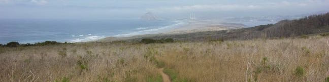
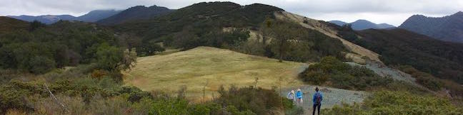
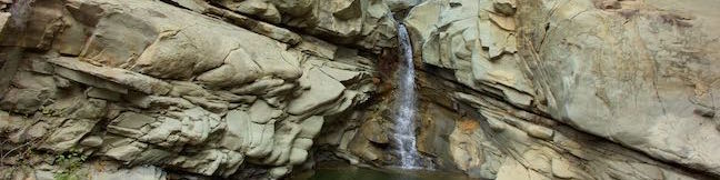
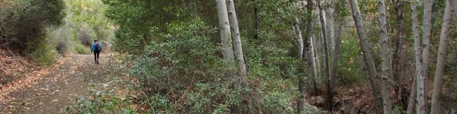
Big Sur is a charming town in Monterey County, 140 miles south of San Francisco. The name also applies to the fifty miles of coastline between Big Sur and San Simeon, which is as beautiful as any in the world. Big Sur is defined by dramatic and beautiful landscapes. Tall green mountains drop to rugged shores and mesmerizing blue waters. [wp_ad_wide_page] Salmon Creek Falls Big Sur The drive up Highway One is so scenic that many people don't get out to hike at all, but they should! ... Read more.
South Dune Trail – Bloody Nose Trail – Hiedra Trail – Hazard Peak Trail Loop in Montaña de Oro State Park
Hikes in Montaña de Oro State Park travel along the coast or delve inland into canyons and up peaks. If you want a mix of hiking environments, consider this four-trail loop, which combines South Dune Trail, Bloody Nose Trail, Hiedra Trail, and Hazard Peak Trail for a 2 2/3 mile round trip hike with a little over 300 feet of elevation change. This loop can be added to the hike up Hazard Peak, adding a loop to summit hike for a just over 6. ...Read more.
Distance: 2.67 miles · Elevation change: 310 feet
By: Published: May 11, 2017 Last updated: April 11, 2026
Rinconada Trail and Bell Mountain in the Santa Lucia Mountains
Rising through grassy meadows, oak woodlands, and chaparral slopes, Rinconada Trail provides North County access to the Santa Lucia Mountains in Los Padres National Forest. Gaze over bucolic valleys on the hike up to a high point in a grassy mountain pass with views over remote ridges and canyons in the Santa Lucia Wilderness. Turn around at an overlook by the crest of Rinconada Trail for a 3-mile round trip hike with 625 feet of elevation change. ...Read more.
Distance: 3 miles · Elevation change: 625 feet
By: Published: April 25, 2017 Last updated: April 18, 2026
Santa Paula Canyon Trail to the Punchbowl in Santa Paula & Los Padres National Forest
Framed by tall, rugged ridges in the Topatopa Mountains, Santa Paula Creek slices through the rockbed of Santa Paula Canyon, carving out alluring pools and cascades called the Punchbowl (or Punch Bowls). Finishing with a flourish, the Punchbowl has a 25-foot waterfall and a pool that you can relax beside. The Punchbowl is located between Big Cone Camp and Cross Camp, two Los Padres National Forest Campgrounds on the East Fork of Santa Paula Canyon. ...Read more.
Distance: 8 miles · Elevation change: 800 feet
By: Published: April 17, 2017 Last updated: April 18, 2026
Sisar Canyon Trail in Santa Paula & Los Padres National Forest
Sisar Canyon cuts into the mountains above Upper Ojai Valley, halfway between Ojai and Santa Paula. A wide dirt trail travels up the canyon toward Topatopa Ridge, a striking bluff of striped rock. Rather than taking Sisar Canyon Trail (also known as Sisar Canyon Road) deep into the Topatopa Mountains, turn around at an overlook 2.75 miles up the trail for a picturesque day hike. ...Read more.
Distance: 6.5 miles · Elevation change: 1200 feet
By: Published: April 5, 2017 Last updated: May 5, 2026
Horn Canyon Trail in Ojai & Los Padres National Forest
Horn Canyon Trail rises into the frontcountry of the Topatopa Mountains from Ojai, California. While you can spend a full day (and a full workout) hiking up Horn Canyon Trail, you can also opt for the shorter option described here, trekking up the trail's moderate opening mile, past multiple creek crossings and views down Ojai Valley, before venturing off trail up the canyon bottom past pools and a small cascade on Thacher Creek. ...Read more.
Distance: 2.9 miles · Elevation change: 750 feet
By: Published: March 31, 2017 Last updated: December 8, 2025