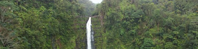
Rainbow Falls Lookout Hike Wailuku River State Park Hilo Big Island Hawaii
A mile and a half from downtown Hilo, the biggest city on the Big Island of Hawaii, Rainbow Falls pours over a basalt ledge in Hawaii's longest river. The 80-foot tall waterfall takes a broad single-drop plunge. Visitors can see Rainbow Falls (and hopefully a morning rainbow) from Rainbow Falls Lookout in Wailuku River State Park, where 0.2 miles of lets-be-generous-and-call-it-hiking leads to one viewpoint facing the waterfall and another perch alongside the top of Rainbow Falls. ...Read more.
My Hikes: Completed hikeA green icon of shows a picture of a landscape with a check mark in the upper right corner, signifying that this is a hike you would like to put on your completed list.OK! Add to trails I've hiked
My Hikes: Want to hikeA green icon of shows a picture of a landscape with a heart in the upper right corner, signifying that this is a hike you would like to put on your to-do list.OK! Add to trails I want to hike
TagsA green icon depicting a tags represents a list of words and phrases that this content is tagged with Tagged with · Free Trails · Hawaii State Parks · Hilo · Waterfalls
Hike DistanceA green icon of a hiker used to label information about the length of the hike Distance: 0.2 miles · Elevation change: 40 feet
By: Published: Last updated: May 13, 2025
Akaka Falls State Park Waterfall hike Hilo Big Island Hawaii Akaka Falls Loop Trail
‘Akaka Falls is stunner – considered one of the most beautiful waterfalls in Hawaii – with a 442-foot single-drop into a tropical valley. This great waterfall is paired with a great viewpoint. A paved 0.55-mile long loop trail leads to a lookout in front of ‘Akaka Falls, while also providing a glimpse of 300-foot tall Kahuna Falls and several small cascades. ...Read more.
My Hikes: Completed hikeA green icon of shows a picture of a landscape with a check mark in the upper right corner, signifying that this is a hike you would like to put on your completed list.OK! Add to trails I've hiked
My Hikes: Want to hikeA green icon of shows a picture of a landscape with a heart in the upper right corner, signifying that this is a hike you would like to put on your to-do list.OK! Add to trails I want to hike
TagsA green icon depicting a tags represents a list of words and phrases that this content is tagged with Tagged with · Hawaii State Parks · Honomu · Waterfalls
Hike DistanceA green icon of a hiker used to label information about the length of the hike Distance: 0.55 miles · Elevation change: 115 feet
By: Published: Last updated: May 13, 2025
Waipio Valley Overlook Viewpoint Waipio Lookout Big Island Hawaii
Waipi‘o Valley is a rugged, beautiful, and historic Hawaiian valley on the north side of the Big Island. The verdant valley has a mile long black sand beach framed by steep, thousand foot-tall cliffs. Get a good look at Waipi‘o Valley from a perch at the rim of the valley wall. Waipio Lookout has interesting info panels and impressive views. The lookout is also the launch point for a rewarding hike to Waipi‘o Beach and Muliwai Trail Overlook. ...Read more.
TagsA green icon depicting a tags represents a list of words and phrases that this content is tagged with Tagged with · Ocean Views · Waipio Valley
By: Published: Last updated: April 26, 2019
Waipio Valley Road Waipio Beach Muliwai Trail Overlook Hike Waipi'o Valley Hi'ilawe Falls Lookout Hawaii
Waipi‘o Valley is known as the Valley of Kings for its regal chapter in Hawaiian history. You're bound to feel high and mighty while looking across this remote valley and its pristine beach from a panoramic perch on Muliwai Trail. Waipi‘o Valley has steep, thousand foot-tall cliffs, so entering the valley is no simple stroll. Cross Waipi‘o Beach and visit Muliwai Trail Overlook on a 4. ...Read more.
My Hikes: Completed hikeA green icon of shows a picture of a landscape with a check mark in the upper right corner, signifying that this is a hike you would like to put on your completed list.OK! Add to trails I've hiked
My Hikes: Want to hikeA green icon of shows a picture of a landscape with a heart in the upper right corner, signifying that this is a hike you would like to put on your to-do list.OK! Add to trails I want to hike
TagsA green icon depicting a tags represents a list of words and phrases that this content is tagged with Tagged with · Beaches · Free Trails · Kohala Forest Reserve · Ocean Views · Waipio Valley · Waterfalls
Hike DistanceA green icon of a hiker used to label information about the length of the hike Distance: 4.88 miles · Elevation change: 1300 feet
By: Published: Last updated: October 21, 2025
Kiholo State Park Reserve Wainanalii Lagoon Kiholo Bay Hike Kona Big Island of Hawaii Black sand Beach Hike
While much of Hawai‘i's coastline is understandably built up with vacation destination resorts, some areas have a wilder feel, like Kīholo Bay. Driftwood decorates the rugged coastline, just 25 miles north of Kona, and green sea turtles ease through the bay's cyan-colored shallows. The Hawaii State Parks website describes Kīholo State Park Reserve as: A stark, lava-covered coastal park with small bays, sparsely vegetated coastline, historic lava flows, and wide open spaces. ...Read more.
My Hikes: Completed hikeA green icon of shows a picture of a landscape with a check mark in the upper right corner, signifying that this is a hike you would like to put on your completed list.OK! Add to trails I've hiked
My Hikes: Want to hikeA green icon of shows a picture of a landscape with a heart in the upper right corner, signifying that this is a hike you would like to put on your to-do list.OK! Add to trails I want to hike
TagsA green icon depicting a tags represents a list of words and phrases that this content is tagged with Tagged with · Beaches · Free Trails · Hawaii State Parks · Kona · Tide Pools
Hike DistanceA green icon of a hiker used to label information about the length of the hike Distance: 2 miles · Elevation change: 15 feet
By: Published: Last updated: May 13, 2025
Kalahuipua'a Trail and Fishponds Loop Hike Puako Hawaii Moana Lani Kalahuipua'a Historic Park
A list of things for hikers to do on the Big Island of Hawai‘i includes: walking across a lava field, exploring a cave, looking for petroglyphs, seeing fishponds created by early Hawaiians, and taking a time-out by tide pools in a beautiful bay. Check off everything on that list with one visit to Kalahuipua‘a Historic Park and Fishpond Preserve. ...Read more.
My Hikes: Completed hikeA green icon of shows a picture of a landscape with a check mark in the upper right corner, signifying that this is a hike you would like to put on your completed list.OK! Add to trails I've hiked
My Hikes: Want to hikeA green icon of shows a picture of a landscape with a heart in the upper right corner, signifying that this is a hike you would like to put on your to-do list.OK! Add to trails I want to hike
TagsA green icon depicting a tags represents a list of words and phrases that this content is tagged with Tagged with · Beaches · Fishponds · Free Trails · Lava Tubes · Puako · Tide Pools
Hike DistanceA green icon of a hiker used to label information about the length of the hike Distance: 1.7 miles · Elevation change: 30 feet
By: Published: Last updated: July 25, 2025
Malama Trail Puako Petroglyph Archeological District Hike Hawaii Puako Petroglyph Park Moana Lani Kona Area Rock Carvings
On the Big Island of Hawai‘i, Puakō Petroglyph Archeological District is one of the best places to see rock carvings created by early Hawaiians. Malama Trail offers two hiking itineraries: Keep things easy with a 0.2-mile round trip hike on a paved wheelchair-friendly path to an enjoyable collection of reproductions that match the area's authentic petroglyphs A rougher trail continues to the Puakō Petroglyph Field, where a thousand rock carvings can be observed, capping off a 1. ...Read more.
My Hikes: Completed hikeA green icon of shows a picture of a landscape with a check mark in the upper right corner, signifying that this is a hike you would like to put on your completed list.OK! Add to trails I've hiked
My Hikes: Want to hikeA green icon of shows a picture of a landscape with a heart in the upper right corner, signifying that this is a hike you would like to put on your to-do list.OK! Add to trails I want to hike
TagsA green icon depicting a tags represents a list of words and phrases that this content is tagged with Tagged with · Beaches · Free Trails · Petroglyphs · Puako
Hike DistanceA green icon of a hiker used to label information about the length of the hike Distance: 1.2 miles · Elevation change: 30 feet
By: Published: Last updated: July 18, 2025
Forest Park Loop Hike Wild Cherry Trail Alder Trail Portland Oregon
What will you find under the canopy of Forest Park? Dirt single tracks weave through verdant woodlands, passing Douglas firs and bigleaf maples bedecked with licorice ferns. Explore some of Forest Park's charmingly ridges and ravines on this 3.5-mile loop with 510 feet of elevation change. Although Wild Cherry Trail and Alder Trail are the most notable members of this hike, this circuit actually comes together with the use of a few other trail: Leif Erikson Trail, Wildwood Trail, Keil Trail, and a sliver of Dogwood Trail. ...Read more.
My Hikes: Completed hikeA green icon of shows a picture of a landscape with a check mark in the upper right corner, signifying that this is a hike you would like to put on your completed list.OK! Add to trails I've hiked
My Hikes: Want to hikeA green icon of shows a picture of a landscape with a heart in the upper right corner, signifying that this is a hike you would like to put on your to-do list.OK! Add to trails I want to hike
TagsA green icon depicting a tags represents a list of words and phrases that this content is tagged with Tagged with · Forest Park · Free Trails · Northwest Portland · Tualatin Mountains · West Hills of Portland
Hike DistanceA green icon of a hiker used to label information about the length of the hike Distance: 3.5 miles · Elevation change: 510 feet
By: Published: Last updated: October 21, 2025
Wild Cherry Trail Dogwood Trail Leif Erikson Drive Loop Hike Forest Park Portland Oregon
Looking for a Forest Park hike that can be completed in about an hour? Delve into the woods on this 2.5-mile loop that explores a soothing swath of Forest Park. The loop has 515 feet of elevation change, traveling downhill from Northwest 53rd Drive on Wild Cherry Trail before rising back up Dogwood Trail. Wild Cherry Trail – Dogwood Trail Loop starts from one of the roadside parking area along NW 53rd Drive, 0. ...Read more.
My Hikes: Completed hikeA green icon of shows a picture of a landscape with a check mark in the upper right corner, signifying that this is a hike you would like to put on your completed list.OK! Add to trails I've hiked
My Hikes: Want to hikeA green icon of shows a picture of a landscape with a heart in the upper right corner, signifying that this is a hike you would like to put on your to-do list.OK! Add to trails I want to hike
TagsA green icon depicting a tags represents a list of words and phrases that this content is tagged with Tagged with · Forest Park · Free Trails · Northwest Portland · Tualatin Mountains · West Hills of Portland
Hike DistanceA green icon of a hiker used to label information about the length of the hike Distance: 2.5 miles · Elevation change: 515 feet
By: Published: Last updated: October 21, 2025
Alder Island Nature Trail Siletz Bay National Wildlife Refuge Hike Lincoln City Oregon Coast Trail
Just south of Lincoln City on the Oregon coast, Highway 101 crosses the Siletz River as it flows into Siletz Bay and the Pacific Ocean. It is at this location that you will find Alder Island Nature Trail, which opened in 2017 and offers a level 0.85-mile loop hike around an island between the river and its marshes. While it might lack the ocean views of surrounding coastal hikes, Alder Island Nature Trail is a tranquil spot for a short, easy outing with wildlife-viewing opportunities. ...Read more.
My Hikes: Completed hikeA green icon of shows a picture of a landscape with a check mark in the upper right corner, signifying that this is a hike you would like to put on your completed list.OK! Add to trails I've hiked
My Hikes: Want to hikeA green icon of shows a picture of a landscape with a heart in the upper right corner, signifying that this is a hike you would like to put on your to-do list.OK! Add to trails I want to hike
TagsA green icon depicting a tags represents a list of words and phrases that this content is tagged with Tagged with · Depoe Bay · Free Trails · Lincoln City · Siletz Bay National Wildlife Refuge
Hike DistanceA green icon of a hiker used to label information about the length of the hike Distance: 0.85 miles · Elevation change: 5 feet
By: Published: Last updated: June 28, 2021