Pilot Butte Trail Bend Oregon Hike Pilot Butte Nature Trail Pilot Butte State Park
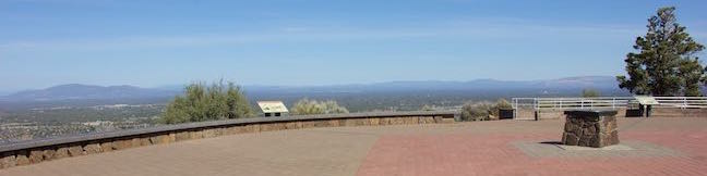
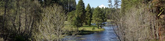
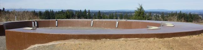
Pilot Butte is the biggest landmark in the city of Bend. This extinct cinder volcano is visible from almost everywhere in the city and its summit surpasses expectations with knock-out views of over Bend toward high desert landscapes and snowcapped Cascade Mountains. An extraordinary collection of mountains that includes Mount Hood, Mount Jefferson, Three Fingered Jack, the Three Sisters and Mount Bachelor are visible on clear days. ...Read more.
My Hikes: Completed hikeA green icon of shows a picture of a landscape with a check mark in the upper right corner, signifying that this is a hike you would like to put on your completed list.OK! Add to trails I've hiked
My Hikes: Want to hikeA green icon of shows a picture of a landscape with a heart in the upper right corner, signifying that this is a hike you would like to put on your to-do list.OK! Add to trails I want to hike
TagsA green icon depicting a tags represents a list of words and phrases that this content is tagged with Tagged with · Bend · Buttes · Free Trails · Pilot Butte State Park · Summits
Hike DistanceA green icon of a hiker used to label information about the length of the hike Distance: 1.8 miles · Elevation change: 475 feet
By: Published: Last updated: December 6, 2025
Head of the Metolius Springs Metolius River Headwaters Deschutes National Forest Central Oregon Hike
Gaze north from the observation site at the end of Head of the Metolius Trail and you'll have a beautiful (if traditional) view of a river flowing through a pine forest toward Mount Jefferson. Look in the other direction to see something surprising. The river springs to live all at once from a gushing source. The trail to Head of the Metolius in Deschutes National Forest is a quarter mile long and paved. ...Read more.
My Hikes: Completed hikeA green icon of shows a picture of a landscape with a check mark in the upper right corner, signifying that this is a hike you would like to put on your completed list.OK! Add to trails I've hiked
My Hikes: Want to hikeA green icon of shows a picture of a landscape with a heart in the upper right corner, signifying that this is a hike you would like to put on your to-do list.OK! Add to trails I want to hike
TagsA green icon depicting a tags represents a list of words and phrases that this content is tagged with Tagged with · Camp Sherman · Cascade Range · Deschutes National Forest · Free Trails · Sisters
Hike DistanceA green icon of a hiker used to label information about the length of the hike Distance: 0.5 miles · Elevation change: 35 feet
By: Published: Last updated: December 5, 2025
Lower Macleay Trail to Stone House Witch's Castle Forest Park Portland Oregon Willamette Heights Loop Lower Macleay Park
Do you like to hike but suffer from a little bit of fomo (fear of missing out)? Make your way to Northwest Portland for an outing in Forest Park that has a bit of everything. Start up Lower Macleay Trail along Balch Creek, the park's biggest year-round stream. Hike less than a mile through a verdant rainforest to arrive at Stone House (imaginatively nicknamed the Witch's Castle), where the ruins of an old building are alluringly grown over with moss and ferns. ...Read more.
My Hikes: Completed hikeA green icon of shows a picture of a landscape with a check mark in the upper right corner, signifying that this is a hike you would like to put on your completed list.OK! Add to trails I've hiked
My Hikes: Want to hikeA green icon of shows a picture of a landscape with a heart in the upper right corner, signifying that this is a hike you would like to put on your to-do list.OK! Add to trails I want to hike
TagsA green icon depicting a tags represents a list of words and phrases that this content is tagged with Tagged with · Forest Park · Free Trails · Macleay Park · Northwest Portland · Tualatin Mountains · West Hills of Portland
Hike DistanceA green icon of a hiker used to label information about the length of the hike Distance: 2 miles · Elevation change: 400 feet
By: Published: Last updated: December 5, 2025
Lower Macleay Park to Pittock Mansion via Lower Macleay Trail Wildwood Trail Upper Macleay Trail Forest Park Hike Portland Oregon
Hike a couple miles through the temperate rainforest in Forest Park and you could easily forget how close you are to downtown Portland. Jog your memory by hiking up to Pittock Mansion for a major view over the city. This 5.4-mile hike with 850 feet of elevation change starts from Lower Macleay Park in Northwest Portland. Stroll along Balch Creek on Lower Macleay Trail to Stone House and examine captivating ruins that make a fine destination on their own. ...Read more.
My Hikes: Completed hikeA green icon of shows a picture of a landscape with a check mark in the upper right corner, signifying that this is a hike you would like to put on your completed list.OK! Add to trails I've hiked
My Hikes: Want to hikeA green icon of shows a picture of a landscape with a heart in the upper right corner, signifying that this is a hike you would like to put on your to-do list.OK! Add to trails I want to hike
TagsA green icon depicting a tags represents a list of words and phrases that this content is tagged with Tagged with · Forest Park · Free Trails · Macleay Park · Northwest Portland · Tualatin Mountains · West Hills of Portland
Hike DistanceA green icon of a hiker used to label information about the length of the hike Distance: 5.4 miles · Elevation change: 850 feet
By: Published: Last updated: December 5, 2025
Powell Butte Hike Mountain View Trail Summit Lane Portland Oregon
Are you in Portland, Oregon? Is it a clear day? If you answered yes to these questions, start making your way to Powell Butte. Located on the southeast side of the city, the butte is kept green by a 612-acre municipal park that offers several hiking trails for visitors. A short walk up a paved trail from the visitor center leads to the butte's 630-foot summit, which can offer salivating views of Mount Saint Helens, Mount Hood, and other peaks. ...Read more.
My Hikes: Completed hikeA green icon of shows a picture of a landscape with a check mark in the upper right corner, signifying that this is a hike you would like to put on your completed list.OK! Add to trails I've hiked
My Hikes: Want to hikeA green icon of shows a picture of a landscape with a heart in the upper right corner, signifying that this is a hike you would like to put on your to-do list.OK! Add to trails I want to hike
TagsA green icon depicting a tags represents a list of words and phrases that this content is tagged with Tagged with · Buttes · Free Trails · Portland · Powell Butte Nature Park · Southeast Portland
Hike DistanceA green icon of a hiker used to label information about the length of the hike Distance: 2.15 miles · Elevation change: 165 feet
By: Published: Last updated: December 5, 2025
Multnomah-Wahkeena Loop Columbia River Gorge National Scenic Area Oregon Multnomah Falls Larch Mountain Trail Wahkeena Trail Hike Wahkeena Falls Fairy Falls Ecola Falls Weisendanger Falls Waterfalls
Multnomah Falls is the tallest waterfall in Oregon and not the sort of waterfall that leaves you asking for more. Still, the Columbia River Gorge has so many waterfalls to offer that you can pair scoping out Multnomah Falls from top to bottom with admiring a quintet of other waterfalls on an immensely beautiful hike. This loop combines Wahkeena Trail with Larch Mountain Trail and is 6. ...Read more.
My Hikes: Completed hikeA green icon of shows a picture of a landscape with a check mark in the upper right corner, signifying that this is a hike you would like to put on your completed list.OK! Add to trails I've hiked
My Hikes: Want to hikeA green icon of shows a picture of a landscape with a heart in the upper right corner, signifying that this is a hike you would like to put on your to-do list.OK! Add to trails I want to hike
TagsA green icon depicting a tags represents a list of words and phrases that this content is tagged with Tagged with · Cascade Range · Columbia River Gorge National Scenic Area · Free Trails · Waterfalls
Hike DistanceA green icon of a hiker used to label information about the length of the hike Distance: 6.05 miles · Elevation change: 1525 feet
By: Published: Last updated: December 5, 2025
Horsetail Falls Trail – Oneonta Trail Loop Hike to Ponytail Falls Middle Oneonta Falls Columbia River Gorge National Scenic Area Oregon
Do you have a need for waterfalls? Heading to the Columbia River Gorge is a good start (the area is stocked full of them). If you choose to hike Horsetail Falls Trail, you'll get a tall waterfall right at the trailhead. Half a mile up the trail, you'll find another waterfall that you can actually walk behind. Combine Horsetail Falls Trail and Oneonta Trail for a 2. ...Read more.
My Hikes: Completed hikeA green icon of shows a picture of a landscape with a check mark in the upper right corner, signifying that this is a hike you would like to put on your completed list.OK! Add to trails I've hiked
My Hikes: Want to hikeA green icon of shows a picture of a landscape with a heart in the upper right corner, signifying that this is a hike you would like to put on your to-do list.OK! Add to trails I want to hike
TagsA green icon depicting a tags represents a list of words and phrases that this content is tagged with Tagged with · Cascade Range · Columbia River Gorge National Scenic Area · Free Trails · Waterfalls
Hike DistanceA green icon of a hiker used to label information about the length of the hike Distance: 2.85 miles · Elevation change: 325 feet
By: Published: Last updated: December 5, 2025
Forest Park Hike to Pittock Mansion Wildwood Trail Upper Macleay Trail Portland Oregon
Pittock Mansion is a popular place to visit in Portland, perhaps less for the building itself than for its view over city and surrounding mountains. You can drive right up to Pittock Mansion and take a tour or hike up through Forest Park and immerse yourself in a temperate rainforest that's closer to the city than you might expect. Start from Cornell Road for a partial loop hike on Wildwood Trail and Upper Macleay Trail that is 2. ...Read more.
My Hikes: Completed hikeA green icon of shows a picture of a landscape with a check mark in the upper right corner, signifying that this is a hike you would like to put on your completed list.OK! Add to trails I've hiked
My Hikes: Want to hikeA green icon of shows a picture of a landscape with a heart in the upper right corner, signifying that this is a hike you would like to put on your to-do list.OK! Add to trails I want to hike
TagsA green icon depicting a tags represents a list of words and phrases that this content is tagged with Tagged with · Forest Park · Free Trails · Northwest Portland · Portland · Tualatin Mountains · West Hills of Portland
Hike DistanceA green icon of a hiker used to label information about the length of the hike Distance: 2.5 miles · Elevation change: 435 feet
By: Published: Last updated: December 5, 2025
Lower Oneonta Falls Adventure Oneonta Gorge Waterfall hike Columbia River Gorge National Scenic Area Oregon
Lower Oneonta Falls is an enchantress – a 100-foot ribbon of white water plunging down a steep wall of dark volcanic rock draped in moss and ferns. Getting to this waterfall demands an off-trail adventure up Oneonta Gorge that involves wading through crystal clear stretches of Oneonta Creek as it passes between the towering walls of this narrow gorge. ...Read more.
My Hikes: Completed hikeA green icon of shows a picture of a landscape with a check mark in the upper right corner, signifying that this is a hike you would like to put on your completed list.OK! Add to trails I've hiked
My Hikes: Want to hikeA green icon of shows a picture of a landscape with a heart in the upper right corner, signifying that this is a hike you would like to put on your to-do list.OK! Add to trails I want to hike
TagsA green icon depicting a tags represents a list of words and phrases that this content is tagged with Tagged with · Cascade Range · Closed · Columbia River Gorge National Scenic Area · Free Trails · Waterfalls
Hike DistanceA green icon of a hiker used to label information about the length of the hike Distance: 0.8 miles · Elevation change: 25 feet
By: Published: Last updated: December 5, 2025
Spencer Butte Hike Eugene Oregon Ridgeline Trail Spencer Butte Summit
Spencer Butte rises high above the south end of the Willamette Valley near Eugene, Oregon. A 5.2-mile round trip hike to the mountaintop crosses through a lush forest covered in ferns and ascends to a nearly treeless 2,060-foot summit where there are round-the-compass views over Lane County's bucolic valleys and evergreen-covered hills. The woodland walk at the start is pleasant enough to be its own attraction, and the panoramic summit really puts this hike over the top. ...Read more.
My Hikes: Completed hikeA green icon of shows a picture of a landscape with a check mark in the upper right corner, signifying that this is a hike you would like to put on your completed list.OK! Add to trails I've hiked
My Hikes: Want to hikeA green icon of shows a picture of a landscape with a heart in the upper right corner, signifying that this is a hike you would like to put on your to-do list.OK! Add to trails I want to hike
TagsA green icon depicting a tags represents a list of words and phrases that this content is tagged with Tagged with · Buttes · Eugene · Summits
Hike DistanceA green icon of a hiker used to label information about the length of the hike Distance: 5.2 miles · Elevation change: 1100 feet
By: Published: Last updated: December 5, 2025