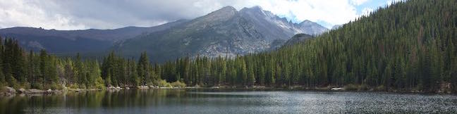
Emerald Lake Trail Nymph Lake Dream Lake Emerald Lake Rocky Mountain National Park Bear Lake to Emerald Lake Hike Colorado
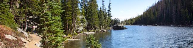
Emerald Lake Trail visits a trio of beautiful mountain lakes in Rocky Mountain National Park, easing past Nymph Lake and Dream Lake on the way to Emerald Lake, which is cradled below 12,000-foot peaks along the Continental Divide. This three-lake hike is 3.6 miles round trip with 650 feet of elevation change. This scenic hike begins from Bear Lake Trailhead, where a fourth lake can added to... Read more.
OK! Add to trails I’ve hiked
OK! Add to trails I want to hike
Tagged with · Continental Divide · Lakes · National Parks · Rocky Mountains
Distance: 3.6 miles · Elevation change: 650 feet
By: Published: Last updated: September 11, 2019
Bear Lake Nature Trail Rocky Mountain National Park Bear Lake Loop Hike Colorado Bear Lake Trail
To explore an area of lake-filled basins below the Continental Divide, follow Bear Lake Road into the center of Rocky Mountain National Park. Several trails leave from Bear Lake Trailhead, including a three-lake trek to Nymph Lake, Dream Lake, and Emerald Lake. For something shorter, the 2/3 of a mile long stroll around Bear Lake has lots of appeal. Bear Lake Nature Trail passes numerous... Read more.
OK! Add to trails I’ve hiked
OK! Add to trails I want to hike
Tagged with · Lakes · National Parks · Nature Trails · Rocky Mountains
Distance: 0.65 miles · Elevation change: 60 feet
By: Published: Last updated: April 1, 2017
Rattlesnake Gulch Trail hike Eldorado Canyon State Park Boulder Colorado
Eldorado Canyon State Park preserves a truly golden section of the Rocky Mountain Foothills near Boulder, Colorado. Its pointed cliffs framing South Boulder Creek are a playground for climbers. Hikers have a lot to enjoy as well, like Rattlesnake Gulch Trail, which is scenic and attraction-packed, covering 3.8 miles on a lollipop loop. The hike takes a moderate route up the side of... Read more.
OK! Add to trails I’ve hiked
OK! Add to trails I want to hike
Tagged with · Boulder · Colorado State Parks · Eldorado State Park · Ruins
Distance: 3.8 miles · Elevation change: 985 feet
By: Published: Last updated: April 23, 2017
Devils Kitchen Trail is located near the south end of Colorado National Monument at the bottom of rugged No Thoroughfare Canyon. This 1.2-mile hike ascends 225 feet to visits an intriguing rock formation on the side of the canyon where tall boulders have enclosed a rock grotto
Devils Kitchen Trail is located near the south end of Colorado National Monument at the bottom of rugged No Thoroughfare Canyon. This 1.2-mile hike ascends 225 feet to visits an intriguing rock formation on the side of the canyon where tall boulders have enclosed a rock grotto. No Thoroughfare Canyon Two junctions are along the way and the path gets faint toward the end, so follow the... Read more.
OK! Add to trails I’ve hiked
OK! Add to trails I want to hike
Tagged with · Desert Canyons · Fruita · Grand Junction
Distance: 1.2 miles · Elevation change: 225 feet
By: Published: Last updated: June 3, 2017
Monument Canyon Trail to Independence Monument in Colorado National Monument near Grand Junction Colorado
Monument Canyon Trail is six miles long in one direction, dropping from Rim Rock Drive across Monument Canyon to a second trailhead on the eastern edge of the park. Three and a half miles (and 850 vertical feet) from the top, the trail passes Independence Monument, the largest freestanding rock formation in the park. A popular hike along Monument Canyon Trail is a 7-mile out and back from... Read more.
OK! Add to trails I’ve hiked
OK! Add to trails I want to hike
Tagged with · Desert Canyons · Fruita · Grand Junction
Distance: 7 miles · Elevation change: 850 feet
By: Published: Last updated: June 3, 2017
Coke Ovens Trail hike Colorado National Monument Canyon
Coke Oven's Trail shares a trailhead with Monument Canyon Trail and the collection of rock domes can be visited as their own destination or as a side attraction on a longer trek into Monument Canyon. The hike to Coke Ovens is one-mile round trip with 180 feet of elevation loss. From the turnout along Rim Rock Drive, begin hiking east into the canyon. After descending switchbacks for... Read more.
OK! Add to trails I’ve hiked
OK! Add to trails I want to hike
Tagged with · Desert Canyons · Fruita · Grand Junction
Distance: 1 mile · Elevation change: 180 feet
By: Published: Last updated: June 4, 2017
Otto's Trail Colorado National Monument Ottos Trail Hike
Otto's Trail is one of the shorter hikes along Rim Rock Drive in Colorado National Monument. Like Window Rock Trail, this 0.75-mile stroll descends gradually to a cliff overlooking Monument Canyon. The view showcases Independence Monument, the tallest freestanding formation in the canyon, and a point of fascination for visitors dating back to the first park supervisor, John Otto, for whom... Read more.
OK! Add to trails I’ve hiked
OK! Add to trails I want to hike
Tagged with · Desert Canyons · Fruita · Grand Junction
Distance: 0.75 miles · Elevation change: 85 feet
By: Published: Last updated: June 4, 2017
Alcove Nature Trail in Colorado National Monument near Grand Junction Colorado
Across the road from the park visitor center (and Canyon Rim Trail) is Alcove Nature Trail. This track is set back from the canyon rim, which limits views of the great landscape. What this trail offers instead is an informative hike with numbered markers that coincide with entries in a guide booklet. The entries describe plants and animals in the park as well as the geological history.... Read more.
OK! Add to trails I’ve hiked
OK! Add to trails I want to hike
Tagged with · Desert Canyons · Fruita · Grand Junction · Nature Trails
Distance: 1 mile · Elevation change: 175 feet
By: Published: Last updated: June 4, 2017
Canyon Rim Trail Colorado National Monument
For a view of Praying Hands, Independence Monument, and the other statuesque monoliths in Monument Canyon, take a stroll along Canyon Rim Trail. The track crosses the canyon rim between Saddlehorn Visitor Center and Book Cliff View, and is a great way to begin your visit of Colorado National Monument. The trail is half a mile one-way or one mile round trip. Additionally, the hike can be... Read more.
OK! Add to trails I’ve hiked
OK! Add to trails I want to hike
Tagged with · Desert Canyons · Fruita · Grand Junction
Distance: 1 mile · Elevation change: 100 feet
By: Published: Last updated: June 4, 2017
Window Rock Trail in Colorado National Monument Colorado hiking Window Rock Trail begins next to Bookcliff Shelter, not far from Saddlehorn Campground. The trail looks south into Monument Canyon and north over the cities below. This 1/3-mile round trip hike ends at a distinct point at the north end of the western wall of Monument Canyon where a natural window pierces the top of the cliff.
Window Rock Trail begins next to Bookcliff Shelter, not far from Saddlehorn Campground. The trail looks south into Monument Canyon and north over the cities below. This 1/3-mile round trip hike ends at a distinct point at the north end of the western wall of Monument Canyon where a natural window pierces the top of the cliff. Window Rock Window Rock Trail is wide and easy to follow,... Read more.
OK! Add to trails I’ve hiked
OK! Add to trails I want to hike
Tagged with · Desert Canyons · Fruita · Grand Junction
Distance: 0.35 miles · Elevation change: 60 feet
By: Published: Last updated: June 4, 2017