Salt Creek Trail Death Valley National Park hike Salt Creek Interpretive Trail California
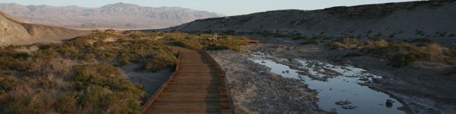
Salt Creek Interpretive Trail is a level, 1-mile long boardwalk loop along what would be considered a pitiful creek anywhere outside of Death Valley National Park. Here it is extraordinary! The salinated stream is home to the Salt Creek Pupfish, a unique and bizarre creature that can survive in these harsh conditions. The small fish is most visible in these waters in the spring. Salt... Read more.
By: Published: Last updated: June 7, 2017
Grotto Canyon Hike Death Valley National Park California Hiking Trail
More than a hike, Grotto Canyon in an adventure. The unmarked road leading up the canyon does not show up on park maps, and the canyon itself has an undeveloped feeling of discovery. Rock obstacles in narrow sections of the canyon require some technical climbing, so this is not a stroll for beginners (nearby Mosaic Canyon is more appropriate for those hikers). Grotto Canyon The gravel... Read more.
By: Published: Last updated: June 7, 2017
Death Valley Sand Dunes
The most visible (but not the largest) sand dunes in Death Valley National Park are the Mesquite Flat Dunes. A small parking lot located off Highway 190, two miles south of Stove Pipe Wells offers a great starting point for a trek out to the dunes. There is no formal trail to follow, just strike out for the high sands, which are reachable within a half mile. Cross the ridges and aim for... Read more.
By: Published: Last updated: February 5, 2024
Mosaic Canyon Trail Death Valley National Park hike California
Walled with both mosaic conglomerates and smooth marbleized rocks, Mosaic Canyon is a fine specimen the geology of Death Valley National Park. Marble Canyon Trail travels up the canyon bottom past all the interesting features for an outing of 1 to 4 miles round trip. Mosaic Canyon From the parking lot at the mouth of the canyon, it is just a short walk into Lower Mosaic Canyon. Hike up... Read more.
By: Published: Last updated: June 7, 2017
Ubehebe Crater Death Valley National Park Crater hike California desert
Ubehebe Crater is located in the north end of Death Valley National Park near the Eureka Dunes and Scotty's Castle. A parking lot along the rim provides a great view of the crater, and three trails offer even more. The Science Ubehebe Crater is a maar volcano that was created by a phreatic eruption two to seven thousand years ago. Hot magma converted groundwater into steam, which created... Read more.
By: Published: Last updated: May 13, 2025
Catalina Island Hike Hermit Gulch Trans-Catalina Trail
Take an 11.75-mile hike over the ridges above Avalon on Hermit Gulch Trail - Trans-Catalina Trail Loop, gathering amazing ocean views, in two directions at times, as well as perspectives over the pristine interior of the island. This hike offers a scenic loop on picturesque southeast end of Santa Catalina Island. Those staying at Hermit Gulch Campground are already at the trailhead for... Read more.
By: Published: Last updated: January 16, 2018
Hermit Falls Santa Anita Canyon Waterfall hike Angeles National Forest Trail Arcadia cliff jumping
This 2.6-mile round trip hike visits a short waterfall downstream from Sturtevant Falls in the Angeles National Forest. Hermit Falls receives fewer visitors than its neighbor but is a popular swimming hole for cliff jumpers in the spring and summer. The trailhead is at 2,180 feet, while the falls are at 1,430, making this is an upside down hikes where the uphill comes at the end. ... Read more.
By: Published: Last updated: May 13, 2025
Santa Anita Canyon Loop San Gabriel Mountain Santa Anita Canyon Hike Los Angeles
See the best that Santa Anita Canyon has to offer. Visit Hoegees Camp, Mount Zion, and Sturtevant Falls on one hike leaving Chantry Flats in the San Gabriel Mountains. In John W. Robinson's excellent guide book, Trails of the Angeles, Santa Anita Canyon Loop is described as: One of the best [loop hikes] in the San Gabriels. It's hard to argue with that distinction. At 9.5 miles in... Read more.
By: Published: Last updated: May 13, 2025
Mt Zion view hiking trail Angeles National Forest Santa Anita Canyon hike Arcadia
After hiking to Spruce Grove Camp above Sturtevant Falls, why not return to Chantry Flats by crossing over Mount Zion? The trail to Mount Zion passes along the east side of a ridge leading up to the summit. The grade is gentle, and after all the demanding switches beneath Spruce Grove, the trail feels surprisingly kind. Only 400 feet of elevation separate Spruce Grove Camp and Mount Zion,... Read more.
By: Published: Last updated: June 11, 2019
Mount Zion Trail Santa Anita Canyon hike Angeles National Forest San Gabriel Mountains Lower Zion Trail Arcadia
If you enjoy the 4.25-mile round trip hike to Hoegees Camp, press on to Mount Zion. This trail leaves the banks of Winter Creek for higher ground and panoramic views of Santa Anita Canyon. Less than a quarter mile above Hoegees Camp on Lower Winter Creek Trail, is a junction with Lower Zion Trail. Upper Winter Creek Trail continues straight ahead, returning to Chantry Flats, but if you turn... Read more.
By: Published: Last updated: June 11, 2019