Trail of 100 Giants Sequoia National Forest Western Divide Ranger District hike Giant Sequoia National Monument Giant Sequoia Grove hiking trail
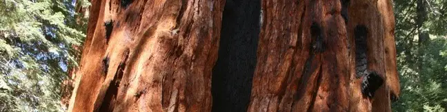
The Trail of 100 Giants offers a leisurely loop through a grove of giant sequoias. With easy access off the Western Divide Highway, this is practically a required stop on a trip to Giant Sequoia National Monument. Located within Long Meadow Grove, this trail gives visitors an opportunity to revel beneath these enormous beauties. Enjoy a half-mile paved loop or extend things a bit on a... Read more.
By: Published: Last updated: June 4, 2017
Salmon Falls Trail Salmon Creek Big Sur Hike
Salmon Creek Trail is a popular track with backpackers venturing deep into the Silver Peak Wilderness in the Monterey District of Los Padres National Forest, but you only need to hike a quarter mile round trip from Highway One to see a beautiful 120-foot waterfall. Unlike the trail overlooking beautiful McWay Falls farther up the Big Sur Coast, this hike brings you up close and person with a... Read more.
OK! Add to trails I’ve hiked
OK! Add to trails I want to hike
Tagged with · Big Sur · Free Trails · Los Padres National Forest · Silver Peak Wilderness · Waterfalls
Distance: 0.25 miles · Elevation change: 60 feet
By: Published: Last updated: June 11, 2019
Jade Cove Plaskett Rock point Pacific Coast Bluff Trail Los Padres National Forest Big Sur Hike
Along the bluffs of the Big Sur Coast protected by Los Padres National Forest is a scenic and easy ocean-view hike. Jade Cove and Plaskett Rock Point are just south of Plaskett Creek Campground on the west side of Highway One. Visited together, they form a 1.5-mile hike. This hike has two trailheads. Both are unmarked a somewhat difficult to spot. From Plaskett Creek Campground drive a... Read more.
OK! Add to trails I’ve hiked
OK! Add to trails I want to hike
Tagged with · Big Sur · Free Trails · Los Padres National Forest · Ocean Views · Wildflowers
Distance: 1.5 miles · Elevation change: 150 feet
By: Published: Last updated: June 4, 2017
Partington Cove Trail Julia Pfeifer Burns State Park Trail Big Sur Hike
A great way to explore the dramatic waterfront on the Big Sur coast is to take a hike down the action-packed Partington Cove Trail. Partington Cove is part of Julia Pfeiffer Burns State Park begins from Highway One, just north of McWay Falls. Partington Cove Trail The 1.5-mile hike to Partington Cove begins at the top of a gated fire road on the west side of Highway One and descends... Read more.
OK! Add to trails I’ve hiked
OK! Add to trails I want to hike
Tagged with · Big Sur · California State Parks · Free Trails · Julia Pfeiffer Burns State Park · Ocean Views
Distance: 1.5 miles · Elevation change: 270 feet
By: Published: Last updated: April 9, 2019
McWay Falls Julia Pfeiffer Burns State Park Waterfall Big Sur Hike California Trail beach waterfall McWay Falls Monterey County California
The overlook trail for McWay Falls is a must-stop for anyone taking the scenic drive up Highway One along the Big Sur Coast. The waterfall is stunning, dropping some 80 feet onto a pristine beach in an enchanting cove. It is a short 0.6-mile round trip hike to a viewpoint for McWay Falls, which can be reached directly from Highway One or from parking areas withing Julia Pfieffer Burns State... Read more.
By: Published: Last updated: May 21, 2024
Darwin Falls Death Valley Darwin Waterfall hiking trail desert hike
Darwin Falls should not be part of Death Valley National Park. In fact, the year-round waterfall does not belong in the California desert at all. The hike starts as innocently as so many nearby trails, at the mouth of a gravel-bottom canyon, but after 0.7 miles the canyon closes and the trail enters a lush oasis of cottonwoods and willows. The next 0.3 miles involve multiple creek... Read more.
OK! Add to trails I’ve hiked
OK! Add to trails I want to hike
Tagged with · Desert Canyons · National Parks · Waterfalls
Distance: 2 miles · Elevation change: 275 feet
By: Published: Last updated: March 24, 2019
Sidewinder Canyon hike Death Valley National Park hiking trail
Sidewinder Canyon is located at the base of the Black Mountains on the east side of Death Valley National Park south of Badwater Basin. The canyon is fairly wide with a gravel bottom and forty-foot stone walls on both side. Within these walls lie tight slot canyons with pour-overs, carve outs, and dark passages that beg to be explored. There are three slot canyons off the south wall of the... Read more.
OK! Add to trails I’ve hiked
OK! Add to trails I want to hike
Tagged with · Desert Canyons · National Parks · Off Trail
Distance: 7 miles · Elevation change: 750 feet
By: Published: Last updated: June 7, 2017
Wildrose Peak Trail Death Valley National Park Hike Wildrose Peak
Wildrose Peak resides on the northern end of a group of peaks that form the top of the Panamint Mountain Range, which runs down the west side of Death Valley National Park. The 9,064-foot peak is about seven miles north of Telescope Peak, the highest point in the park at 11,049 feet. Wildrose sports an expansive view of the Panamint Mountains, Badwater Basin, and the surrounding desert... Read more.
OK! Add to trails I’ve hiked
OK! Add to trails I want to hike
Tagged with · National Parks · Summits
Distance: 8.4 miles · Elevation change: 2200 feet
By: Published: Last updated: June 4, 2017
Mojave Desert Petroglyphs North Lava Bed Wash 17 mile point Mojave National Preserve California
Visitors driving though Mojave National Preserve between Baker and Kelso Depot may wish to stop near Seventeen Mile Point for a quick walk to simple petroglyphs drawn into the volcanic rock outcroppings along the road. While certainly not the only petroglyphs in the preserve, these might be the easiest to get to. A petroglyph engraved into the rock On Kelbaker Road, 13.4 miles from... Read more.
OK! Add to trails I’ve hiked
OK! Add to trails I want to hike
Tagged with · Free Trails · Lava · Petroglyphs
Distance: 0.25 miles · Elevation change: 25 feet
By: Published: Last updated: November 9, 2018
Silver Peak Trail Hike Mojave National Preserve California
This 8.5-mile hike ascends 2,500 feet to summit a 6,365-foot peak in the small range of mountains in the southwestern corner of Mojave National Preserve. Silver Peak looks out across the Granite Mountains toward the Kelso Dunes, Cima Dome, and the peaks of the Providence Range - a worthy view of Mojave National Preserve to be sure. Nearby Granite Peak is the tallest mountain in the range... Read more.
OK! Add to trails I’ve hiked
OK! Add to trails I want to hike
Tagged with · Closed · Free Trails · Off Trail · Summits
Distance: 8.5 miles · Elevation change: 2500 feet
By: Published: Last updated: February 19, 2020