Lost Cabin Trail Malibu Creek State Park California Hiking Trail
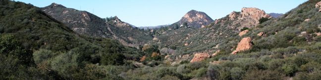
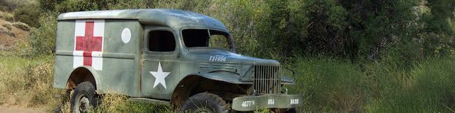
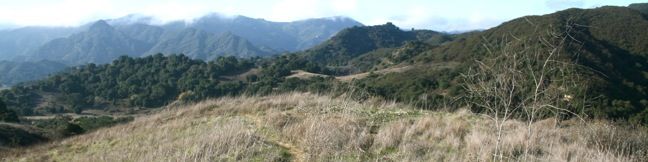
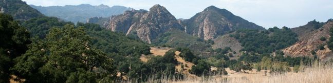
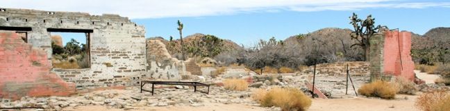
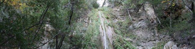
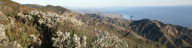
Lost Cabin Trail is a 0.75-mile long dead-end single track departing from Crags Road near the location where the MASH television show was filmed. The trail ends in a mountain canyon at an empty plot where a cabin once stood. Though there is no longer evidence of the cabin's existence, the trek still offers hikers immersion into a remote section of Malibu Creek State Park behind the Goat... Read more.
By: Published: Last updated: December 22, 2018
MASH television set Malibu Creek State Park hike
Far from the Hollywood Sign and the Walk of Fame, Malibu Creek State Park holds its own bit of Hollywood history. The exterior set for the long-running television show M*A*S*H was filmed in a Korea-resembling corner of park. While the medic tents have been removed, the location is still recognizable, and Malibu Creek State Park has gone above and beyond to create a rich experience for... Read more.
By: Published: Last updated: May 13, 2025
Talepop Loop Hike Malibu Creek State Park Talepop Loop Trail North Grassland Trail Las Virgenes Valley Liberty Canyon Trail Las Virgenes Canyon Trail
Talepop Loop explores the north end of Malibu Creek State Park through a region long inhabited by Chumash Indians who had a village here named Talepop. Hikers today are exposed to signs of modern humanity like ranches and electric lines, but despite being suspiciously close to two major roadways, Talepop Trail escapes the man-made world to explore a beautiful patch of the Santa Monica... Read more.
By: Published: Last updated: May 13, 2025
South Grassland Trail Hike to Rock Pool in Malibu Creek State Park Crags Road lollipop loop Mulholland Highway hike Grassland Trailhead.
South Grassland Trail enters Malibu Creek State Park from Mulholland Highway, providing a scenic stroll over rolling hills. The trail ends at Crags Road, the major hiking artery through the park. If you are familiar with hiking out of the main parking lot, starting on the Grassland Trail adds about 0.9 miles to those hikes. By entering on Grassland Trail, visitors also avoid driving into... Read more.
By: Published: Last updated: May 13, 2025
Wonderland Wash Trail Joshua Tree National Park Wonderland Wash Hike
In between Barker Dam Trail and Wall Street Mill Trail is Wonderland Wash Trail, an unmaintained single track through the Wonderland of Rocks in Joshua Tree National Park. This less-traveled trail passes monzogranite mounds that are a popular playground for rock climbers and bouldering enthusiasts. There is no defined end to the trail, but a hike to the prominent rock formation known as the... Read more.
OK! Add to trails I’ve hiked
OK! Add to trails I want to hike
Tagged with · Bouldering · National Parks
Distance: 2.1 miles · Elevation change: 75 feet
By: Published: Last updated: January 16, 2020
Wall Street Mill Trail Joshua Tree National Park - hike - California - Queen Valley - Wonderland of Rocks - trek
For the first half of the 20th century, the desert land now known as Joshua Tree National Park was scattered with miners on the hunt for gold and silver. When ore was mined, it was sent to a mill to be crushed and have the precious metal extracted. The ore from Desert Queen Mine and other mining operations passed through Wall Street Mill, which is located in Queen Valley near the Wonderland... Read more.
OK! Add to trails I’ve hiked
OK! Add to trails I want to hike
Tagged with · National Parks · Ruins
Distance: 2.15 miles · Elevation change: 115 feet
By: Published: Last updated: January 16, 2020
Contact Mine in Joshua Tree National Park: Contact Mine was in operation at the start of the 20th century, extracting gold and silver from the mountains south of Twentynine Palms, California. A hundred years of desert decay have left the mine rusty but recognizable. The old road to the mine is worn down and eroded, now a little-used trail that provides access to hikers. This 3.95-mile round trip trek ascends 710 feet up a wash, a canyon, and an old road to a mountainside mine site that offers a glimpse into the mining history of Joshua Tree National Park.
Contact Mine was in operation at the start of the 20th century, extracting gold and silver from the mountains south of Twentynine Palms, California. A hundred years of desert decay have left the mine rusty but recognizable. The old road to the mine is worn down and eroded, now just a little-used hiking trail. This 3.95-mile round trip trek ascends 700 feet up a wash, a canyon, and an old... Read more.
OK! Add to trails I’ve hiked
OK! Add to trails I want to hike
Tagged with · Desert Canyons · Mines · National Parks · Off Trail
Distance: 3.95 miles · Elevation change: 700 feet
By: Published: Last updated: January 16, 2020
Arch Rock Trail Joshua Tree National Park White Tank Granite Arch Rock Hike Arch Rock Joshua Tree
Want to see a natural arch in Joshua Tree National Park? Take a short hike to Arch Rock within the granite formations surrounding White Tank Campground. An easy and enjoyable 0.3-mile loop leaving the campground is a must-do stroll for anyone staying at White Tank Campground. Other park visitors can now enjoy a 1.3-mile lollipop loop hike that begins from a trailhead along Pinto Basin... Read more.
OK! Remove from my hikes
OK! Add to trails I want to hike
Tagged with · Arches · National Parks · Nature Trails
Distance: 1.3 miles · Elevation change: 100 feet
By: Published: Last updated: May 13, 2025
Nojoqui Falls Park Trail Solvang Santa Barbara Hike
Nojoqui Falls Parks is located just off Highway 101 north of the Gaviota Tunnel between Santa Barbara and Buellton. In addition to picnic tables and playing fields, the park offers a short hike to an eighty-foot waterfall. This two-thirds of a mile round trip trail ascends 175 feet up a shaded canyon to the enchanting Nojoqui Falls. Nojoqui Falls Trail There are no junctions on the... Read more.
OK! Add to trails I’ve hiked
OK! Add to trails I want to hike
Tagged with · Free Trails · Gaviota State Park · Santa Ynez Mountains · Waterfalls
Distance: 0.65 miles · Elevation change: 175 feet
By: Published: Last updated: June 2, 2017
Gaviota Peak Trespass Trail Los Padres Santa Barbara hike - Gaviota Peak sits at the lofty west end of the Santa Ynez Mountains behind Santa Barbara. The 2,458-foot peak is just two miles from the Pacific Ocean, putting it in prime position to offer eye-popping views. There are two routes to the summit from the trailhead in Gaviota State Park. The traditional Gaviota Peak Trail is 3.15 miles one-way, while the immensely scenic Trespass Trail is 3.35 miles one-way - a superb 6.5-mile loop with 2,150 feet of elevation gain
Gaviota Peak sits at the lofty west end of the Santa Ynez Mountains behind Santa Barbara. The 2,458-foot peak is just two miles from the Pacific Ocean, putting it in prime position to offer eye-popping views. There are two routes to the summit from the trailhead in Gaviota State Park. The traditional Gaviota Peak Trail is 3.15 miles one-way, while the immensely scenic Trespass Trail is 3.35... Read more.
By: Published: Last updated: January 9, 2018