Buttermilk Falls in the Adirondack Mountains
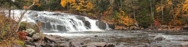
Would you like to try some buttermilk? Take the half-mile round trip hike to Buttermilk Falls in New York's Adirondack Mountains. The short, wide waterfall is a beautiful and easy-to-reach destination on the Raquette River near Long Lake. Buttermilk Falls is one of the area's most popular trails, and rightfully so. The short hike to Buttermilk Falls begins from a trailhead on North Point Road west of Long Lake and north of Blue Mountain Lake. ...Read more.
Distance: 0.5 miles · Elevation change: 25 feet
By: Published: October 12, 2012 Last updated: April 9, 2026
Heaton Flats Trail in the San Gabriel Mountains
Half a mile from the start of the crowded trail to the Bridge to Nowhere, you'll find a junction with Heaton Flats Trail, which rises above the canyon carved by the East Fork of the San Gabriel River to offer big views and plenty of solitude. Enjoy panoramic perspectives of some of the most notable peaks in the San Gabriel Mountains (including Mount Baldy, Mount Baden-Powell, and Iron Mountain) along the trail to a 4,000-foot high clearing on the ridge. ...Read more.
Distance: 6 miles · Elevation change: 2000 feet
By: Published: September 27, 2012 Last updated: December 5, 2025
Cruickshank Trail in the Silver Peak Wilderness
For backpackers and day hikers, Cruickshank Trail offers an extraordinary opportunity to explore the wilderness off Highway One on the beautiful Big Sur Coast. The single track starts by climbing to lofty ocean views, and then heads inland along a canyon wall with relaxing pockets of oaks and redwoods toward a handful of trail camps. The excellent trail to Upper Cruickshank Camp crosses diverse scenery for a 5-mile round trip hike with 1,150 feet of elevation gain, and there are several possible extensions. ...Read more.
Distance: 5 miles · Elevation change: 1150 feet
By: Published: September 17, 2012 Last updated: April 16, 2026
Buckeye Trail in the Silver Peak Wilderness
It can sound like hyperbole when you try to put into words the breathtaking, jaw-dropping stop-you-in-your tracks ocean views found on trails in Big Sur. Never the less, Buckeye Trail has absolutely extraordinary views over the Pacific that you need to see to believe. Rising above Highway One, the trail ventures through the Silver Peak Wilderness, ascending coastal canyons and ridges to panoramic vistas and a number of trail camps. ...Read more.
Distance: 6.5 miles · Elevation change: 1450 feet
By: Published: September 16, 2012 Last updated: April 16, 2026
Bob Jones City to the Sea Bike Trail in Avila Beach and Avila Valley
Are you jonesing for an easy trail that leads to a beach town brimming with oceanfront fun? Take a relaxing trip down Bob Jones Bike Trail to Avila Beach, a small bayside hamlet that can bustle with beachgoers on weekends. The level 5-mile round trip trail is suitable for hikers, joggers, walkers, and bikers. You will enjoy refreshing shade from oaks as you follow San Luis Obispo Creek down Avila Valley to its pacifying ending in Avila Beach. ...Read more.
Distance: 5 miles · Elevation change: 50 feet
By: Published: September 15, 2012 Last updated: April 10, 2026
Uncle Tom’s Trail on the Grand Canyon of the Yellowstone River in Yellowstone National Park
If Uncle Tom's Trail can be called a trail, then you can just as easily say you are going for a hike any time you take the stairs instead of the elevator. This Yellowstone National Park trail consists of over 300 steel steps built down the south wall of the Grand Canyon of the Yellowstone River next to the park's most impressive waterfall. The up-close views of Lower Falls are electrifying and this 0. ...Read more.
Distance: 0.7 miles · Elevation change: 500 feet
By: Published: September 11, 2012 Last updated: April 20, 2026
Point Sublime Trail on the Grand Canyon of the Yellowstone River in Yellowstone National Park
The people in charge of naming landmarks at Yellowstone National Park didn't hold back when they assigned the name Point Sublime to a viewpoint on the south rim of the Grand Canyon of the Yellowstone River. The trail to Point Sublime offers views that can't be seen from a car, exploring the picturesque canyon wall beyond Artist Point. It is 3 miles round trip to Point Sublime with a gradual 250 feet of elevation gain. ...Read more.
Distance: 3 miles · Elevation change: 250 feet
By: Published: September 10, 2012 Last updated: April 9, 2026
North Rim Trail on the Grand Canyon of the Yellowstone River in Yellowstone National Park
No trip to Yellowstone National Park is complete without a visit to the Grand Canyon of the Yellowstone River, a deep chasm with two fetching waterfalls. You can get numerous memorable views of the canyon by hiking along North Rim Trail, which stretches 3.8 miles over a paved and unpaved path crossing the northwest wall of the Grand Canyon of the Yellowstone River (with just 250 feet of elevation change). ...Read more.
Distance: 7.6 miles · Elevation change: 250 feet
By: Published: September 7, 2012 Last updated: April 16, 2026
Artist Point on the Grand Canyon of the Yellowstone River in Yellowstone National Park
Artist Point is one of the marquee overlooks on the Grand Canyon of the Yellowstone River, with an exceptional perspective of canyon's most famous feature, the 308-foot Lower Falls. The viewpoint juts out from the south wall of the canyon and is just a short 0.1-mile walk from South Rim Drive. Beyond the paved trail, you can continue hiking along the south rim of the canyon to places like Point Sublime. ...Read more.
Distance: 0.2 miles · Elevation change: 50 feet
By: Published: September 6, 2012 Last updated: April 13, 2026
Brink of the Upper Falls Trail on the Grand Canyon of the Yellowstone River in Yellowstone National Park
The Grand Canyon of the Yellowstone River begins at Upper Falls, cutting a 20-mile long, 1,000-foot deep gash across Yellowstone National Park. Walk right up to the edge of the dramatic tumbler on Brink of the Upper Falls Trail and stare down the thundering 109-foot waterfall. You can visit the Brink of the Upper Falls as a spur off North Rim Trail or as a short standalone hike from a parking area just uphill from the waterfall. ...Read more.
Distance: 0.4 miles · Elevation change: 75 feet
By: Published: September 5, 2012 Last updated: April 10, 2026