Lava Butte in Newberry National Volcanic Monument
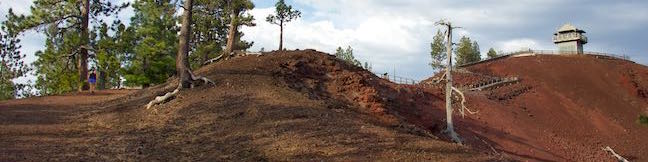
Lava Butte is a 500-foot tall cinder cone along the Northwest Rift of Newberry Volcano in Central Oregon. It rises prominently over Route 97 between Bend and Sunriver. A fire lookout tower sits atop Lava Butte and is joined by a rim trail that offers panoramic views over a dark volcanic landscape. Lava Butte also provides majestic views of the Cascade Mountains to the west. ...Read more.
Distance: 3.85 miles · Elevation change: 520 feet
By: Published: November 9, 2016 Last updated: December 5, 2025
Black Butte in Deschutes National Forest
Black Butte is one of the most identifiable summits in Central Oregon. This conical volcano rises 3,000 feet over tapered terrain on the east side of the Cascade Mountains. Black Butte stands on its own and offers tremendous views over the surroundings including peaks in the Central Oregon Cascades to the north, west, and south. Grand views make Black Butte an ideal site for fire lookout towers, which you will find at the summit. ...Read more.
Distance: 4 miles · Elevation change: 1550 feet
By: Published: November 1, 2016 Last updated: December 5, 2025
West Metolius River Trail in Deschutes National Forest
For a relaxing and fascinating hike in Central Oregon, take an easy stroll along the Metolius River. Leaving Lower Canyon Creek Campground, West Metolius River Trail quickly passes fantastical springs where water gushes from a riverbank. Summer wildflowers line the dirt single track as you continue downriver past calms and rapids. Follow the lovely river for 2. ...Read more.
Distance: 5.4 miles · Elevation change: 100 feet
By: Published: October 26, 2016 Last updated: April 16, 2026
Eagle Creek Trail to Punchbowl Falls in Columbia River Gorge
Fantastic waterfalls, dramatic cliffs, charming cascades, and handsome forests entertain hikers on the first couple miles of Eagle Creek Trail. Venture up a scenic canyon on the Oregon side of the Columbia River Gorge near Cascade Locks, following the tumbling water of Eagle Creek. Trek under and across steep cliffs that place cascades in your path. ...Read more.
Distance: 4.55 miles · Elevation change: 400 feet
By: Published: October 24, 2016 Last updated: April 9, 2026
Cascade Mountain and Porter Mountain in the Adirondack Mountains
Southeast of Lake Placid, you'll find a popular hike to a pair of scenic summits. Cascade Mountain (4,098 feet) and Porter Mountain (4,059 feet) are the thirty-sixth and thirty-eighth tallest peaks in the Adirondack Mountains and are members of the 46 Adirondack High Peaks. Cascade and Porter are two of the easiest High Peaks to reach, thanks to maintained trails and a relatively manageable hike length (that still delivers a workout). ...Read more.
Distance: 6.2 miles · Elevation change: 1925 feet
By: Published: October 18, 2016 Last updated: December 5, 2025
Emerald Lake, Dream Lake, and Nymph Lake in Rocky Mountain National Park
Emerald Lake Trail visits a trio of beautiful mountain lakes in Rocky Mountain National Park, easing past Nymph Lake and Dream Lake on the way to Emerald Lake, which is cradled below 12,000-foot peaks along the Continental Divide. This three-lake hike is 3.6 miles round trip with 650 feet of elevation change. This scenic hike begins from Bear Lake Trailhead, where a fourth lake can added to the outing with Bear Lake Nature Trail. ...Read more.
Distance: 3.6 miles · Elevation change: 650 feet
By: Published: October 13, 2016 Last updated: December 5, 2025
Bear Lake Nature Trail in Rocky Mountain National Park
To explore an area of lake-filled basins below the Continental Divide, follow Bear Lake Road into the center of Rocky Mountain National Park. Several trails leave from Bear Lake Trailhead, including a three-lake trek to Nymph Lake, Dream Lake, and Emerald Lake. For something shorter, the 2/3 of a mile long stroll around Bear Lake has lots of appeal. ...Read more.
Distance: 0.65 miles · Elevation change: 60 feet
By: Published: October 13, 2016 Last updated: April 23, 2026
Rattlesnake Gulch Trail in Eldorado Canyon State Park
Eldorado Canyon State Park preserves a truly golden section of the Rocky Mountain Foothills near Boulder, Colorado. Its pointed cliffs framing South Boulder Creek are a playground for climbers. Hikers have a lot to enjoy as well, like Rattlesnake Gulch Trail, which is scenic and attraction-packed, covering 3.8 miles on a lollipop loop. The hike takes a moderate route up the side of Eldorado Canyon to the Crags Hotel Site, the fading ruins of a more-than-century old resort. ...Read more.
Distance: 3.8 miles · Elevation change: 985 feet
By: Published: October 6, 2016 Last updated: December 6, 2025
Castle Peak and Heart Lake in Shasta-Trinity National Forest
The short hike from Castle Lake to Heart Lake explores a scenic part of Shasta-Trinity National Forest near Mount Shasta. The fun doesn't need to stop once you reach that endearing lake. Hike off trail up a ridge from Heart Lake to a summit with extraordinary views that has been given the unofficial name of Castle Peak. You will feel like royalty when you stand on this mountaintop, taking in a bold perspective of the Castle Crags and at least three snow-capped volcanoes (Mount Lassen, Mount Shasta, and Mount McLoughlin) while also looking down over Heart Lake and Castle Lake. ...Read more.
Distance: 3.2 miles · Elevation change: 1180 feet
By: Published: October 3, 2016 Last updated: December 6, 2025
Little Castle Lake and Heart Lake in Shasta-Trinity National Forest
You are bound to fall in love with the hike to Heart Lake. This pint-sized heart-shaped attraction in the Castle Crags Wilderness of Shasta-Trinity National Forest boasts views of Mount Shasta, Black Butte, and surrounding Klamath Mountains. The hike to Heart Lake begins from a trailhead at Castle Lake, a larger mountain lake wrapped by pines and granite cliffs. ...Read more.
Distance: 2.9 miles · Elevation change: 645 feet
By: Published: October 3, 2016 Last updated: April 9, 2026