Franklin Canyon Lake Loop Hike Franklin Canyon Park Beverly Hills Los Angeles trek Chaparral Trail
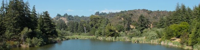
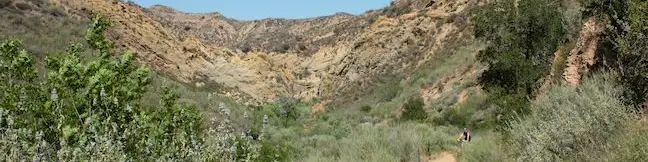
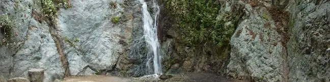
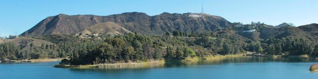
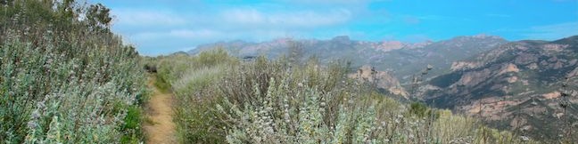
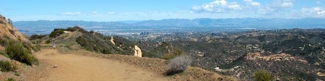
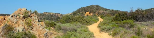
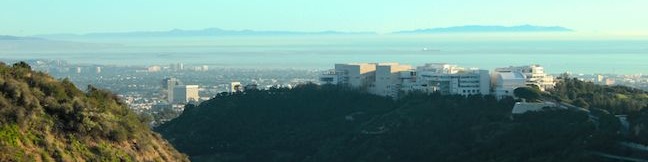
No doubt LA is a busy city, but you can still find calm within the chaos at Franklin Canyon Park. This 605-acre park is tucked into a canyon in the Santa Monica Mountains in Beverly Hills and has a number of trails that allow Angelinos to escape for a couple hours of exercise in nature. North of Hastain Trail (where you can get more of a workout), you will find Upper Franklin Canyon Reservoir (Franklin Canyon Lake), a soothing 3-acre lake joined by an add-on called Heavenly Pond. ...Read more.
My Hikes: Completed hikeA green icon of shows a picture of a landscape with a check mark in the upper right corner, signifying that this is a hike you would like to put on your completed list.OK! Add to trails I've hiked
My Hikes: Want to hikeA green icon of shows a picture of a landscape with a heart in the upper right corner, signifying that this is a hike you would like to put on your to-do list.OK! Add to trails I want to hike
TagsA green icon depicting a tags represents a list of words and phrases that this content is tagged with Tagged with · Beverly Hills · Free Trails · Lakes · Mountains Recreation and Conservation Authority · Dog-Friendly Trails · Santa Monica Mountains
Hike DistanceA green icon of a hiker used to label information about the length of the hike Distance: 2.5 miles · Elevation change: 325 feet
By: Published: Last updated: December 7, 2018
Rocky Peak Park summit hike Simi Valley Los Angeles California
Ed Davis Park in Towsley Canyon is an impressive segment of Santa Clarita Woodlands Park, located on the north side of the Santa Susana Mountains at the north end of Los Angeles County. The trailhead is located just off the 5 Freeway north of the San Fernando Valley, not far from Six Flags Magic Mountain. You don't need a ticket for an adventure in this park, which has its share of natural attractions, like the narrows of Towsley Gorge and seeps of oil and liquid asphalt that pool along the trail. ...Read more.
My Hikes: Completed hikeA green icon of shows a picture of a landscape with a check mark in the upper right corner, signifying that this is a hike you would like to put on your completed list.OK! Add to trails I've hiked
My Hikes: Want to hikeA green icon of shows a picture of a landscape with a heart in the upper right corner, signifying that this is a hike you would like to put on your to-do list.OK! Add to trails I want to hike
TagsA green icon depicting a tags represents a list of words and phrases that this content is tagged with Tagged with · Free Trails · Mountains Recreation and Conservation Authority · Newhall · Santa Clarita Woodlands Park · Santa Susana Mountains · Dog-Friendly Trails · Mountain Biking Trails
Hike DistanceA green icon of a hiker used to label information about the length of the hike Distance: 5.4 miles · Elevation change: 1075 feet
By: Published: Last updated: December 7, 2018
Monrovia Falls Trail in Monrovia Canyon Park San Gabriel Mountains Waterfall Los Angeles hike Pasadena California
The San Gabriel Mountains are graced by several enchanting canyons with sylvan steams flanked by bays and alders. Monrovia Canyon is no exception, complete with a splendid 30-foot waterfall that tops off the experience. Monrovia Falls can be reached from a few different starting points in Monrovia Canyon Park. Falls Trail presents a gradual 1.6-mile round trip hike with 350 feet of elevation gain. ...Read more.
My Hikes: Completed hikeA green icon of shows a picture of a landscape with a check mark in the upper right corner, signifying that this is a hike you would like to put on your completed list.OK! Add to trails I've hiked
My Hikes: Want to hikeA green icon of shows a picture of a landscape with a heart in the upper right corner, signifying that this is a hike you would like to put on your to-do list.OK! Add to trails I want to hike
TagsA green icon depicting a tags represents a list of words and phrases that this content is tagged with Tagged with · Monrovia · Monrovia Canyon Park · Waterfalls · Dog-Friendly Trails · Los Angeles Waterfalls · San Gabriel Mountains
Hike DistanceA green icon of a hiker used to label information about the length of the hike Distance: 1.6 miles · Elevation change: 350 feet
By: Published: Last updated: May 13, 2025
Lake Hollywood Reservoir Walking Trail Los Angeles reservoir loop hike
Hollywood Reservoir (Lake Hollywood) is circled by a paved service road that walkers, joggers, and bikers can use to get lakeside exercise with Hollywood views. The reservoir is located in the hills west of Griffith Park below Cahuenga Peak and Mount Lee (whose summit is world famous for the large white letters that spell HOLLYWOOD). Numerous views of the Hollywood Sign appear on the 3. ...Read more.
My Hikes: Completed hikeA green icon of shows a picture of a landscape with a check mark in the upper right corner, signifying that this is a hike you would like to put on your completed list.OK! Add to trails I've hiked
My Hikes: Want to hikeA green icon of shows a picture of a landscape with a heart in the upper right corner, signifying that this is a hike you would like to put on your to-do list.OK! Add to trails I want to hike
TagsA green icon depicting a tags represents a list of words and phrases that this content is tagged with Tagged with · Free Trails · Lakes · Griffith Park · Santa Monica Mountains
Hike DistanceA green icon of a hiker used to label information about the length of the hike Distance: 3.5 miles · Elevation change: 50 feet
By: Published: Last updated: May 31, 2017
Malibu Springs Trail to Nicholas Flat Malibu California hike Santa Monica Mountains Leo Carrillo State Park Mulholland Highway hike to Nicholas Flat Natural Preserve
Near the west end of Mulholland Highway north of Leo Carrillo State Park, you will find an almost hidden trailhead for Malibu Springs Trail. This spring-loaded single track is faint and overgrown in areas, providing a sense of adventure as you take in fantastic views of the highest peaks Santa Monica Mountains. At the end of an arduous climb, you will drop down to Nicholas Flat in Nicholas Flat Natural Preserve. ...Read more.
My Hikes: Completed hikeA green icon of shows a picture of a landscape with a check mark in the upper right corner, signifying that this is a hike you would like to put on your completed list.OK! Add to trails I've hiked
My Hikes: Want to hikeA green icon of shows a picture of a landscape with a heart in the upper right corner, signifying that this is a hike you would like to put on your to-do list.OK! Add to trails I want to hike
TagsA green icon depicting a tags represents a list of words and phrases that this content is tagged with Tagged with · California State Parks · Free Trails · Leo Carrillo State Park · Malibu · Nicholas Flat Natural Preserve · Ocean Views · Wildflowers · Santa Monica Mountains
Hike DistanceA green icon of a hiker used to label information about the length of the hike Distance: 7 miles · Elevation change: 1425 feet
By: Published: Last updated: May 21, 2024
Mesa Peak hike Backbone Trail Piuma Trailhead Malibu Creek State Park hike Tapia Park ocean view summit Malibu California
A mesa is defined as a flat-topped hill with steep sides. A peak is defined as the pointed top of a mountain. Put these contradictions together and you get a subtle summit with substantial ocean views. This short perch on a mesa-like ridge behind Pepperdine University in Malibu delivers panoramic views over the surrounding Santa Monica Mountains. The hike to Mesa Peak up the steep sides of the mesa begins from the Piuma Trailhead in Malibu Creek State Park and follows 2. ...Read more.
My Hikes: Completed hikeA green icon of shows a picture of a landscape with a check mark in the upper right corner, signifying that this is a hike you would like to put on your completed list.OK! Add to trails I've hiked
My Hikes: Want to hikeA green icon of shows a picture of a landscape with a heart in the upper right corner, signifying that this is a hike you would like to put on your to-do list.OK! Add to trails I want to hike
TagsA green icon depicting a tags represents a list of words and phrases that this content is tagged with Tagged with · Backbone Trail · California State Parks · Malibu · Ocean Views · Summits · Malibu Creek State Park · Santa Monica Mountains
Hike DistanceA green icon of a hiker used to label information about the length of the hike Distance: 6.5 miles · Elevation change: 1375 feet
By: Published: Last updated: May 13, 2025
Calabasas Peak hike trail Los Angeles Calabasas Cold Creek Trail Secret Trail hike Calabasas Peak Motorway
Before it was called Calabasas - Cold Creek Trail, this single track on the northwest side of Calabasas Peak was called the Secret Trail. Well the secret is out and this 4.5-mile round trip trek is a pleasure that all hikers should discover! Tackle 750 feet of elevation change as you cross ridges and ravines topped by sandstone minarets, eventually reaching a 2,163-foot summit with 360 degree views over the Santa Monica Mountains. ...Read more.
My Hikes: Completed hikeA green icon of shows a picture of a landscape with a check mark in the upper right corner, signifying that this is a hike you would like to put on your completed list.OK! Add to trails I've hiked
My Hikes: Want to hikeA green icon of shows a picture of a landscape with a heart in the upper right corner, signifying that this is a hike you would like to put on your to-do list.OK! Add to trails I want to hike
TagsA green icon depicting a tags represents a list of words and phrases that this content is tagged with Tagged with · Free Trails · Summits · Dog-Friendly Trails · Mountain Biking Trails · Santa Monica Mountains
Hike DistanceA green icon of a hiker used to label information about the length of the hike Distance: 4.5 miles · Elevation change: 750 feet
By: Published: Last updated: December 7, 2018
Mount Baden-Powell Trail San Gabriel Mountains hike Mt Baden Powell Summit hike Angeles National Forest Pacific Crest Trail
Mount Baden-Powell is a special summit in the San Gabriel Mountains. It is one of the range's tallest peaks at 9,399 feet and holds particular importance to the Boy Scouts of America because it memorializes the lofty accomplishments of Lord Baden-Powell who founded the Scout Movement. The views are lofty too, lording over an expanse of rugged mountains framed the San Gabriel Valley to the south and the Mojave Desert to the north. ...Read more.
My Hikes: Completed hikeA green icon of shows a picture of a landscape with a check mark in the upper right corner, signifying that this is a hike you would like to put on your completed list.OK! Add to trails I've hiked
My Hikes: Want to hikeA green icon of shows a picture of a landscape with a heart in the upper right corner, signifying that this is a hike you would like to put on your to-do list.OK! Add to trails I want to hike
TagsA green icon depicting a tags represents a list of words and phrases that this content is tagged with Tagged with · Adventure Pass · Angeles National Forest · Azusa · Memorials · Pacific Crest Trail · San Gabriel Mountains National Monument · Silver Moccasin Trail · Summits · Dog-Friendly Trails · San Gabriel Mountains
Hike DistanceA green icon of a hiker used to label information about the length of the hike Distance: 8.25 miles · Elevation change: 2834 feet
By: Published: Last updated: January 9, 2018
Hastain Trail Franklin Canyon Park hike Franklin Canyon Ranch Beverly Hills Los Angeles Discovery Trail hike Hastain Trail Loop
If you are looking for a nice loop hike in the Santa Monica Mountains above Beverly Hills, give Hastain Trail in Franklin Canyon Park a try. Hastain Trail can actually be used for two loops, one easy 1.8-mile loop with 350 feet of elevation gain and one moderate 2.2-mile option with 550 feet of elevation gain. Each trek is a satisfying way to explore Franklin Canyon Park. ...Read more.
My Hikes: Completed hikeA green icon of shows a picture of a landscape with a check mark in the upper right corner, signifying that this is a hike you would like to put on your completed list.OK! Add to trails I've hiked
My Hikes: Want to hikeA green icon of shows a picture of a landscape with a heart in the upper right corner, signifying that this is a hike you would like to put on your to-do list.OK! Add to trails I want to hike
TagsA green icon depicting a tags represents a list of words and phrases that this content is tagged with Tagged with · Beverly Hills · Free Trails · Mountains Recreation and Conservation Authority · Dog-Friendly Trails · Mountain Biking Trails · Santa Monica Mountains
Hike DistanceA green icon of a hiker used to label information about the length of the hike Distance: 2.2 miles · Elevation change: 550 feet
By: Published: Last updated: May 13, 2025
Getty View Park hike East Sepulveda Fire Road Trail Casiano Fire Road trek Santa Monica Mountains Getty Museum vista
The Getty Museum sits on a ridge in the Santa Monica Mountains above the 405 Freeway and has sweeping views over the west side of Los Angeles. East Sepulveda Fire Road (also known as Casiano Fire Road) crosses the ridge on the opposite side of the freeway and has great views of the Getty Museum and Santa Monica Bay. The wide dirt trail crosses a protected section of the Santa Monica Mountains called Getty View Park, and is 1. ...Read more.
My Hikes: Completed hikeA green icon of shows a picture of a landscape with a check mark in the upper right corner, signifying that this is a hike you would like to put on your completed list.OK! Add to trails I've hiked
My Hikes: Want to hikeA green icon of shows a picture of a landscape with a heart in the upper right corner, signifying that this is a hike you would like to put on your to-do list.OK! Add to trails I want to hike
TagsA green icon depicting a tags represents a list of words and phrases that this content is tagged with Tagged with · Bel Air · Free Trails · Getty View Park · Ocean Views · Dog-Friendly Trails · Mountain Biking Trails · Santa Monica Mountains
Hike DistanceA green icon of a hiker used to label information about the length of the hike Distance: 3 miles · Elevation change: 375 feet
By: Published: Last updated: April 16, 2017