Johnson Ranch – Irish Hills Connector Trail in San Luis Obispo
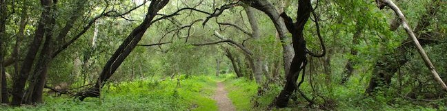
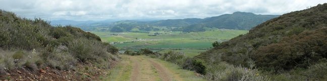
If one park is good, than two parks are better, and a trail between those parks brings out the best of both. Opened in the spring of 2013, the Connector Trail between Johnson Ranch Open Space and the Irish Hills Natural Reserve links two of San Luis Obispo County's great parks. The new trail also connects hikers with grassy slopes and oak-covered ridges with views across San Luis Obispo and Edna Valley. ...Read more.
Tagged with · Free Trails · Irish Hills
Distance: 5 miles · Elevation change: 575 feet
By: Published: April 28, 2013 Last updated: April 23, 2026
Black Hill in Morro Bay State Park
Of all the Morros in San Luis Obispo County, Black Hill is the easiest to summit (even easier than Islay Hill. This 661-foot volcanic peak in Morro Bay State Park can be reached by hiking 0.6 miles round trip up a dirt single track with 190 feet of elevation gain and views over the city of Morro Bay. For those looking for more, there are longer hikes to the summit starting farther down Black Hill. ...Read more.
Distance: 0.6 miles · Elevation change: 190 feet
By: Published: April 26, 2013 Last updated: April 8, 2026
Lake Hollywood Reservoir Walking Trail in Los Angeles
Hollywood Reservoir (Lake Hollywood) is circled by a paved service road that walkers, joggers, and bikers can use to get lakeside exercise with Hollywood views. The reservoir is located in the hills west of Griffith Park below Cahuenga Peak and Mount Lee (whose summit is world famous for the large white letters that spell HOLLYWOOD). Numerous views of the Hollywood Sign appear on the 3. ...Read more.
Distance: 3.5 miles · Elevation change: 50 feet
By: Published: April 24, 2013 Last updated: December 5, 2025
Ennisbrook Trail in San Ysidro Creek Preserve in Montecito
If you are looking for a peaceful stroll in the peaceful Central Coast city of Montecito, examine Ennisbrook Trail. This 1.85-mile lollipop loop with 150 feet of elevation change explores an oak woodland in the 44-acre San Ysidro Creek Preserve. The easy trail is charmed by old stone bridges spanning San Ysidro Creek, which you will follow on this creekside hike. ...Read more.
Tagged with · Free Trails · Montecito · Wildflowers
Distance: 1.85 miles · Elevation change: 150 feet
By: Published: April 24, 2013 Last updated: December 6, 2025
Kumeyaay Village Site in Anza-Borrego Desert State Park
Labeled simply as the Village Site on park maps, the Kumeyaay Village in Anza-Borrego Desert State Park is an easy to visit location where Native Americans lived for thousands of years. Take a short stroll around a pile of boulders along Mine Wash Road and spot grinding holes among the rocks. A sign at the Kumeyaay Village reads: Native desert people have been attracted to the cave of this bouldered hillside for thousands of years. ...Read more.
By: Published: April 20, 2013 Last updated: April 9, 2026
Tamarisk Grove Campground in Anza-Borrego Desert State Park
Tamarisk Grove Campground is one of four developed campgrounds in Anza-Borrego Desert State Park, with 27 sites, plenty of shade, amenities, and nearby hiking trails. Tamarisk Grove has interesting history too, originally serving as a San Diego County prison camp. Thanks to numerous park improvements, it won't feel like you are doing hard time to spend a little time at Tamarisk Grove Campground. ...Read more.
By: Published: April 19, 2013 Last updated: April 19, 2026
Cactus Loop Trail in Anza-Borrego Desert State Park
Broadly speaking, the desert is where you go to find cacti. Speaking specifically, Cactus Loop Trail is where you go in Anza-Borrego Desert State Park to see lots of cacti. True you can spot these prickly plants throughout the park, but this self-guided nature trail explores a rocky ridge that is utterly blanketed with a variety of cacti. A state park provided trail guide pamphlet offers a crash course in the area's unique plants on this 0. ...Read more.
Distance: 0.75 miles · Elevation change: 225 feet
By: Published: April 19, 2013 Last updated: April 9, 2026
Yaqui Well Trail in Anza-Borrego Desert State Park
Yaqui Well Trail is one of the free self-guided nature trails in Anza-Borrego Desert State Park. Pair a trail guide (that you can pick up at the trailhead) with numbered markers along the way to learn about the history and botany of Anza-Borrego Desert State Park as you enjoy the surrounding scenery. The 1.6-mile round trip trail with 100 feet of elevation gain ends at Yaqui Well, a vital year-round water source that stands out from its arid desert surrounding. ...Read more.
Distance: 1.6 miles · Elevation change: 100 feet
By: Published: April 16, 2013 Last updated: April 8, 2026
William L. Kenyon Overlook Trail (Bill Kenyon Trail) in Anza-Borrego Desert State Park
Looks can be deceiving. Kenyon Overlook Trail doesn't impress at the start - a dirt single track leaving the most primitive campground in Anza-Borrego Desert State Park. The trail crosses pleasant but generic desert landscape at Yaqui Pass. Stick with this hike because the payoff is massive - a huge view across Mescal Bajada toward Sunset Mountain (which puts on a colorful display from the overlook at sunset). ...Read more.
Distance: 1.15 miles · Elevation change: 125 feet
By: Published: April 15, 2013 Last updated: April 9, 2026
Marshal South Home Trail in Anza-Borrego Desert State Park
The Anza-Borrego Desert is a beautiful place to visit, but a tough place to live. The areas inhabitants usually built homes near water, trees, and roads, but not Marshal South, who traded utility for scenery when he built a homestead in the 1930s atop Ghost Mountain (Yaquitepec) near Blair Valley in Anza-Borrego Desert State Park. The trail to the ruins of the South's adobe cabin is 1. ...Read more.
Distance: 1.3 miles · Elevation change: 450 feet
By: Published: April 14, 2013 Last updated: April 10, 2026