Angel Vista via Rosewood Trail in the Santa Monica Mountains
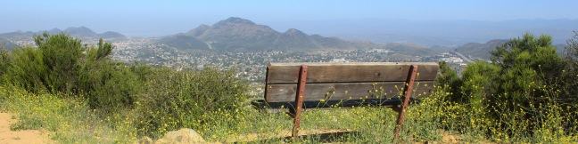
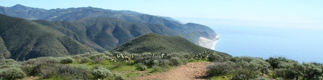
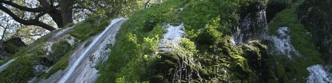
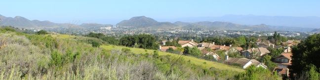
The boldly named Angel Vista is one of the top viewpoints in the Santa Monica Mountains, a coastal range running between Los Angeles and Ventura. Angel Vista soars over Thousand Oaks, presenting panoramic views of the west end of the range, which includes the Boney Mountains, the rocky crown of Santa Monicas. A few trails lead to the vista point, including the 7. ...Read more.
Distance: 4 miles · Elevation change: 850 feet
By: Published: June 2, 2012 Last updated: April 17, 2026
Angel Vista via West Los Robles Trail in the Santa Monica Mountains
Los Robles Trail in Thousand Oaks crosses a chaparral-covered mountainside leading to Angel Vista, one of the premier overlooks on the north side of the Santa Monica Mountains. There are a few routes to the viewpoint, including this 7.6-mile round trip hike up the east end of West Los Robles Trail. The hike charts a steady course along a mountain slope, gaining 800 feet to reach the vista above the Conejo Valley. ...Read more.
Distance: 7.6 miles · Elevation change: 800 feet
By: Published: June 1, 2012 Last updated: April 17, 2026
Sycamore Canyon Campground in Point Mugu State Park
Sycamore Canyon Campground sits just off the beach in Point Mugu State Park on the west end of the Santa Monica Mountains in Malibu. The 13,300-acre park boasts beautiful beaches, rocky peaks, and miles and miles of hiking trails. Tents and RVs are welcome attack this drive-up campground. In addition to beach access, Sycamore Canyon Campground provides fire rings, picnic tables, potable water, coin showers, and flush toilets. ...Read more.
By: Published: February 7, 2012 Last updated: April 19, 2026
Scenic and Overlook Trails Loop in Point Mugu State Park
Point Mugu State Park preserves a stunningly picturesque portion of the Santa Monica Mountains at the west end of Malibu. When you see park trails with names like Scenic Trail and Overlook Trail, you anticipate first class ocean views. Scenic and Overlook Trails Loop delivers the goods! This 2.7-mile hike climbs 425 feet to tremendous vistas atop a ridge west of Big Sycamore Canyon. ...Read more.
Distance: 2.7 miles · Elevation change: 425 feet
By: Published: February 3, 2012 Last updated: April 9, 2026
Mugu Peak in Point Mugu State Park
Just inland from that similarly named point along the California coast, Mugu Peak towers over the Pacific Ocean from an elevation of 1,266 feet. The hike from the bottom of nearby La Jolla Canyon to the top of Mugu Peak is 6.5 miles round trip with 1,225 feet of elevation gain. This is a strenuous trek, rewarded by ridiculous scenery. There is also a longer way to reach the peak, the 11. ...Read more.
Distance: 6.5 miles · Elevation change: 1225 feet
By: Published: February 14, 2011 Last updated: April 9, 2026
La Jolla Canyon Falls in Point Mugu State Park
La Jolla Canyon Falls is a short seasonal waterfall located 3/4 of a mile up La Jolla Canyon Trail in Point Mugu State Park. The twenty-foot cascade offers one of the easiest hikes in the park, with just 250 feet of elevation between the trailhead and the falls. La Jolla Canyon Trail continues above the waterfall, ascending a rocky V-shaped canyon. ...Read more.
Distance: 1.5 miles · Elevation change: 250 feet
By: Published: February 9, 2011 Last updated: April 9, 2026
La Jolla Canyon Loop in Point Mugu State Park
Point Mugu State Park protects 15,000 acres of rustic wilderness on the west end of the Santa Monica Mountains between Oxnard and Malibu. More than 70 miles of trails explore this sprawling park, leaving hikers with options. An excellent way to experience Point Mugu State Park is to set out on a daunting and rewarding 11.75-mile loop. Start at the mouth of La Jolla Canyon just across Highway One from the Pacific Ocean. ...Read more.
Distance: 11.75 miles · Elevation change: 1225 feet
By: Published: February 7, 2011 Last updated: December 9, 2025
Sespe Creek to Willett Hot Springs in Los Padres National Forest
Located just north of Ojai, Sespe Wilderness is the largest wilderness area within Los Padres National Forest, occupying 342 square miles. Sespe Creek cuts through this land and the adjacent trail offers great views of a wide valley and scenic creek. The trail starts from Piedra Blanca trailhead near Rose Valley Falls and leaves the dense green of the bays, oaks, and chaparral for grassland plains that feel surprisingly southwestern. ...Read more.
Distance: 19 miles · Elevation change: 500 feet
By: Published: February 26, 2010 Last updated: December 5, 2025
Wheeler Gorge Campground and Nature Trail in Los Padres National Forest
Wheeler Gorge offers a campground and a nature trail. If you are planning an overnight visit to the Los Padres near Ojai, keep Wheeler Gorge campground as an option. When the free campgrounds fill up with weekend fishermen, Wheeler Gorge is an attractive alternative. Single sites go for $25 a night (and $10 for additional vehicles). Double sites are available for $50 per night (all prices as of 2018). ...Read more.
Distance: 0.7 miles · Elevation change: 100 feet
By: Published: February 25, 2010 Last updated: April 6, 2026
Rose Valley Falls in Los Padres National Forest
Rose Valley Falls is a magnificent two-tier 300-foot waterfall located on the west end of the Topatopa Mountains in Los Padres National Forest. Rose Valley Falls is the tallest waterfall in the range and while it is an easy hike to the base of the 100-foot tall lower tier of the waterfall (0.8 miles round trip with 150 feet of elevation gain), it is adventure to reach the more impressive upper tier. ...Read more.
Distance: 0.8 miles · Elevation change: 150 feet
By: Published: February 25, 2010 Last updated: December 5, 2025