Dune Trail Montaña de Oro State Park Hazard Canyon Reef hike tide pools trail Los Osos California San Luis Obispo
For a quick one-mile jaunt in Montaña de Oro State Park, hike down 
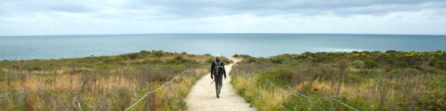
Dune Trail to Hazard Canyon Reef. At the bottom of this oceanfront ravine is a rocky shoreline graced with engaging tide pools. Explore up or down the coast to extend your stay, or settle in for a picnic on the sandy beach. The postcard views of Morro Rock are a good reason to stick around. The trail begins from Hazard... Read more.
By: Published: Last updated: May 11, 2017
Los Osos Oaks California State Natural Reserve hike San Luis Obispo
The 90-acre Los Osos Oaks State Natural Reserve protects a pocket of 800-year-old oaks near San Luis Obispo, California. Los Osos Creek Trail, Chumash Trail, and Oak View Trail loop through the park presenting easy hikes between 0.75 and 1.5 miles. The trails pass beneath (and sometimes between) the gangly branches of pygmy oaks, offering quiet hikes through a shady grove. A bridge into... Read more.
By: Published: Last updated: October 8, 2024
Escondido Falls hiking trail in Malibu Winding Way directions photos pictures and map Escondido Canyon Waterfall
When Escondido Falls is flowing strong, it is flat out one of the finest waterfalls around Los Angeles. The waterfall has an easy-to-reach lower tier that is 50 feet tall and a hard-to-reach upper tier that's 150 feet tall and stunning in optimum conditions. The 3.5 mile round trip hike to Lower Escondido Falls begins just off Pacific Coast Highway and begins by traveling uphill for 0.75... Read more.
By: Published: Last updated: May 13, 2025
Point Dume Natural Preserve Malibu California Overlook Point Dume State Preserve Malibu California hiking trail beach hike to Paradise Cove Pier
If you have driven through Malibu on PCH, then you have seen Point Dume, a dome-shaped promontory jutting into the Pacific at the northwest end of Santa Monica Bay. The point is surrounded by picturesque white sand beaches and sparking blue water. The headland is protected by Point Dume Natural Preserve, a California State Park. A mile of trails on Point Dume's bluffs lead to two overlooks,... Read more.
By: Published: Last updated: May 19, 2024
Mount Baldy hike trail Angeles National Forest California summit highest peak in the San Gabriel mountains Mt Baldy hike mt. baldy Mt Baldy CA
Mount Baldy, Old Baldy, or more formally, Mount San Antonio — whatever you call this mountain, the trek to the summit is considered a right of passage for SoCal hikers. Baldy towers over the San Gabriel Mountains and is the highest point in the range. The far-reaching panoramic views found at the exposed 10,064-foot summit attract plenty of hikers. Two major routes go to the top: ... Read more.
By: Published: Last updated: May 13, 2025
Devils Backbone Trail Mount Baldy San Antonio Mount Baldy Los Angeles San Gabriel Mountains
Devil's Backbone Trail offers spectacular views from an impressive ridge-top trail. The spine-tingling hike along a tantalizing spine starts from Baldy Notch and ends at Mount Baldy, the highest summit in the San Gabriel Mountain. Devil's Backbone Trail is 3.3-miles long with 2,350 feet of elevation gain, and can be reached several ways: From the summit of Mount Baldy after hiking 4.5... Read more.
By: Published: Last updated: June 7, 2018
Baldy Notch San Gabriel Mountains hike Mount Baldy
A trip to Mount Baldy should include a hike along the Devil's Backbone, a daunting ridge east of the summit with tantalizing views. One way to reach Devil's Backbone Trail is to first hike up to the summit of Mount Baldy on Baldy Bowl Trail and then hike down the Devil's Backbone (as you would do on the 11.3-mile Mount Baldy Loop). To start from the bottom of Devil's Backbone Trail, you... Read more.
By: Published: Last updated: May 13, 2025
Mount Baldy Sierra Club Ski Hut Trail Mount Baldy hike San Gabriel Mountains
Baldy Bowl - Ski Hut Trail climbs 3,900 feet over 4.5 miles to the highest summit in the San Gabriel Mountains. The trails ascends the southwest side of the mountain and is the shortest route to the top that does not involve the use of a ski lift. Expect an aggressive climb for most of the hike rewarded by views over San Antonio Canyon. Halfway up the mountain, the trail passes a Sierra Club... Read more.
By: Published: Last updated: April 28, 2017
San Antonio Falls beneath Mount Baldy San gabriel Mountains Waterfall hike
San Antonio is a 75-foot tall multi-tier year-round waterfall carrying water off Mount Baldy. The waterfall swells in late winter and early spring when snow melt increases the flow. The toughest thing about getting to San Antonio Falls isn't the hike, it's the long drive to the base of Mount Baldy. The hike to San Antonio Falls is easy. Simply march 0.6 miles up a paved road to a dirt... Read more.
By: Published: Last updated: June 11, 2019
Manker Flats Campground San Gabriel Mountains camping Angeles National Forest
Manker Flats Campground is perfectly positioned to be a base camp for hikes up Mount Baldy, the highest summit in the San Gabriel Mountains. The 11.3-mile loop hike up Mount Baldy is a full day affair, so if you would like to camp out before or after, claim one of the twenty-one sites at Manker Flats Campground. Campers looking for a shorter hike near Manker Flats may enjoy the 1.4-mile round... Read more.
By: Published: Last updated: October 8, 2024