Hollyridge Trail Beachwood Canyon Hollywood Sign Hike Mount Lee Griffith Park
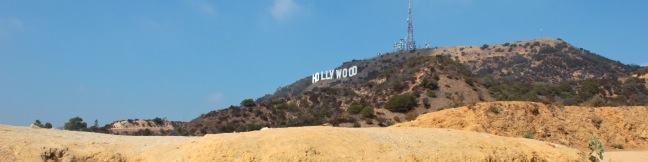
Hikers have several ways to reach the Hollywood Sign atop Mount Lee in Griffith Park. For a short steep hike, you could cross Cahuenga Peak for a tough 3-miler. For a lengthier 6.4-mile trek, you could hike from Brush Canyon Trail to Mount Lee. Hollyridge offers something in the middle, a 3.5-mile round trip hike that climbs 750 feet to the Hollywood Sign. Accessing the trailhead is a... Read more.
By: Published: Last updated: May 13, 2025
Heaton Flats Trail San Gabriel Mountains Angeles National Forest California hike East Fork San Gabriel River Iron Mountain Allison Mine Mount Baden-Powell Sheep Mountain Wilderness
Half a mile from the start of the crowded trail to the Bridge to Nowhere, you'll find a junction with Heaton Flats Trail, which rises above the canyon carved by the East Fork of the San Gabriel River to offer big views and plenty of solitude. Enjoy panoramic perspectives of some of the most notable peaks in the San Gabriel Mountains (including Mount Baldy, Mount Baden-Powell, and Iron... Read more.
By: Published: Last updated: May 19, 2024
Cruickshank Trail Silver Peak Wilderness Los Padres National Forest Big Sur Hike
For backpackers and day hikers, Cruickshank Trail offers an extraordinary opportunity to explore the wilderness off Highway One on the beautiful Big Sur Coast. The single track starts by climbing to lofty ocean views, and then heads inland along a canyon wall with relaxing pockets of oaks and redwoods toward a handful of trail camps. The excellent trail to Upper Cruickshank Camp crosses... Read more.
By: Published: Last updated: July 20, 2018
Buckeye Trail Silver Peak Wilderness Los Padres National Forest Big Sur Hike Buckeye Camp
It can sound like hyperbole when you try to put into words the breathtaking, jaw-dropping stop-you-in-your tracks ocean views found on trails in Big Sur. Never the less, Buckeye Trail has absolutely extraordinary views over the Pacific that you need to see to believe. Rising above Highway One, the trail ventures through the Silver Peak Wilderness, ascending coastal canyons and ridges to... Read more.
By: Published: Last updated: July 20, 2018
Bob Jones City to Sea Bike Trail San Luis Obispo Avila Beach Avila Valley hike ride
Are you jonesing for an easy trail that leads to a beach town brimming with oceanfront fun? Take a relaxing trip down Bob Jones Bike Trail to Avila Beach, a small bayside hamlet that can bustle with beachgoers on weekends. The level 5-mile round trip trail is suitable for hikers, joggers, walkers, and bikers. You will enjoy refreshing shade from oaks as you follow San Luis Obispo Creek... Read more.
By: Published: Last updated: April 23, 2017
Fish Canyon Narrows Trail Sierra Pelona Mountains Los Angeles National Forest California hike Templin Highway Redrock Canyon Cienega Campground Pianobox Prospect backpacking backcountry narrow slot canyon Castaic Lake Fish Canyon Trail Santa Clarita
Not to be confused with Fish Canyon Falls on the east end of the Angeles National Forest, the Fish Canyon Narrows reside on the far west end of the Angeles in the Sierra Pelona Mountains north of Santa Clarita. Here a mountain stream passes through hundred-foot cliffs that are at time only twenty feet apart. The red rock walls mimic those you might find hiking in Zion National Park or other... Read more.
By: Published: Last updated: October 8, 2024
Winston Ridge and Winston Peak Trail Los Angeles hike San Gabriel Mountains Angeles National Forest California La Cañada Flintridge Cloudburst Summit Pacific Crest Trail
Winston Ridge and Winston Peak are name-sharing neighbors in the high San Gabriel Mountains near the Mount Waterman Ski Area. While Winston Peak is the high point of the hike at 7,502 feet, the summit is covered with pines that leave little room for panoramic views. The best vistas come from the shorter 7,003-foot Winston Ridge, which has fewer pines and broader views. To bag the Double... Read more.
By: Published: Last updated: January 10, 2018
Mount Hillyer hike Los Angeles San Gabriel Mountains hike Angeles National Forest California San Gabriel Mountains National Monument
Rising to just over 6,200 feet, Mount Hillyer is actually one of the easier summits to reach in the high country of the San Gabriel Mountains. Beyond its boulder piles and pine forests, the stretched-out summit offers several sweeping views of nearby peaks and canyons. The shortest route to the summit involves hiking 1.33 miles up Mount Hillyer Trail from Horse Flats Campground, gaining 575... Read more.
By: Published: Last updated: January 10, 2018
Horse Flats Campground Los Angeles Camp San Gabriel Mountains Angeles National Forest California tent camping
Horse Flats Campground is a 25-site camping spot operated by the Angeles National Forest in San Gabriel Mountains National Monument, located in the high elevation of the San Gabriel Mountains. At 5,650 feet above sea level, or a mile higher than Los Angeles, the campground feels far from home, even through it is only about 30 miles from the city at the base of the mountains. As the name... Read more.
By: Published: Last updated: October 8, 2024
Chumash Painted Cave State Historic Park Santa Barbara California Los Padres National Forest Painted Cave Road
Chumash Painted Cave State Historic Park preserves centuries old Native American artwork that graces the wall of a sandstone cave in the Santa Ynez Mountains behind Santa Barbara. Chumash Painted Cave can be reached by walking a couple hundred feet up a trail on Painted Cave Road. The trailhead is just two miles from California Route 154, making it a quick, convenient, and interesting stop... Read more.
By: Published: Last updated: February 5, 2025