Switzer Falls
in the San Gabriel Mountains

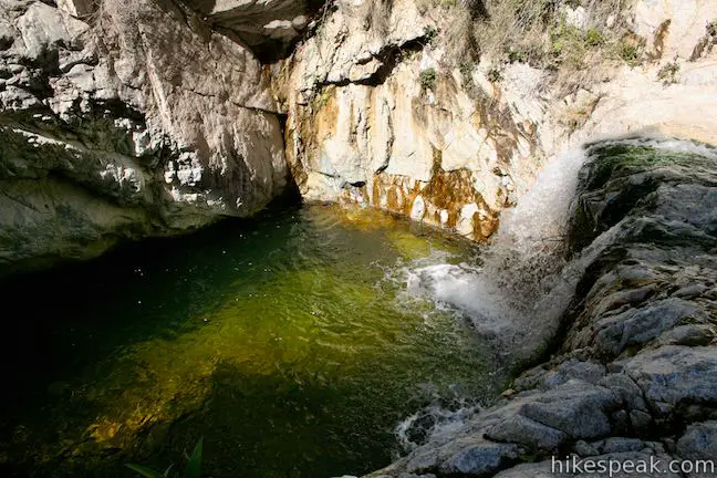
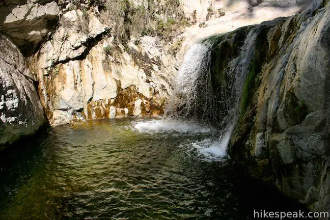
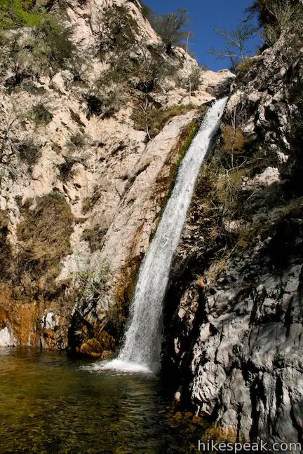
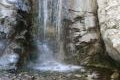
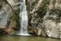
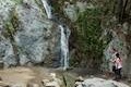
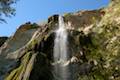
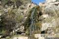
Switzer Falls might be the best know waterfall hike in Los Angeles County. This 50-foot waterfall is reached via a 4.5 mile out-and-back trek on Gabrielino Trail that follows a shaded babbling creek down into a wooded canyon. This is one of the most popular hikes in front range of the San Gabriel Mountains, with a picnic area at the trailhead that gets crowded too. This upside down hike descends 650 feet from Switzer Picnic Area to the stream below Switzer Falls.
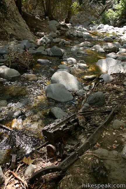
The trail to Switzer Falls begins at Switzer Picnic Area, ten miles up CA 2 from Altadena. Cross the bridge and walk down Bear Canyon on a road that was paved back in the 1930s and is losing its battle with nature and time. This first stretch of the hike is in the shade, with a few crossing of the Arroyo Seco and the opportunity to visit resort era ruins.
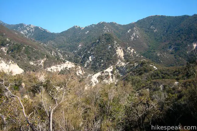
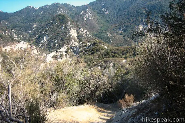
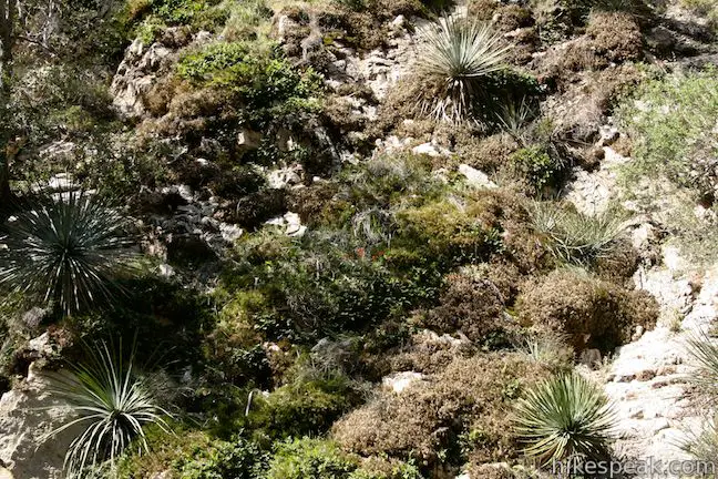
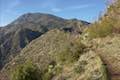
After a mile (where you can enjoy wild blackberries in the summer), Gabrielino Trail leaves the creek and climbs up the side of the canyon. You will be exposed to plenty of views and sunshine as the trail runs along the steep wall of the canyon.
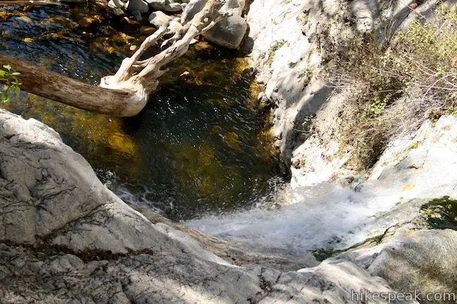
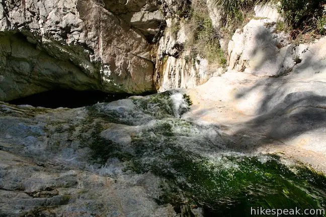
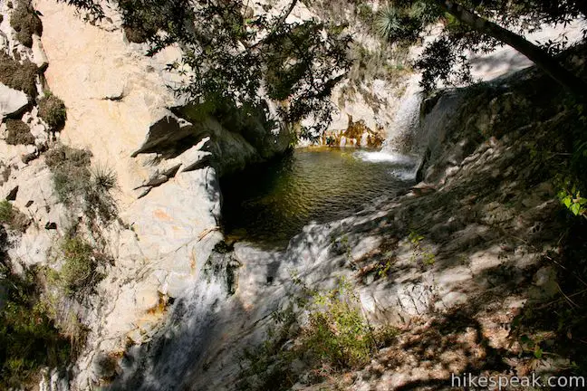
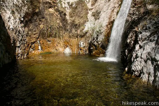
At around 1.5 miles from the start, stay left through a junction where Gabrielino Trail ascends to the right. Continue along the side of Bear Canyon, enjoying a perspective of the top of Switzer Falls. Bear Canyon Trail descends to the creek. Turn upstream toward Switzer Falls and find fellow hikers enjoying small pools and cascades beneath the waterfall.
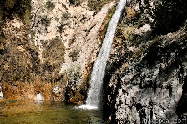
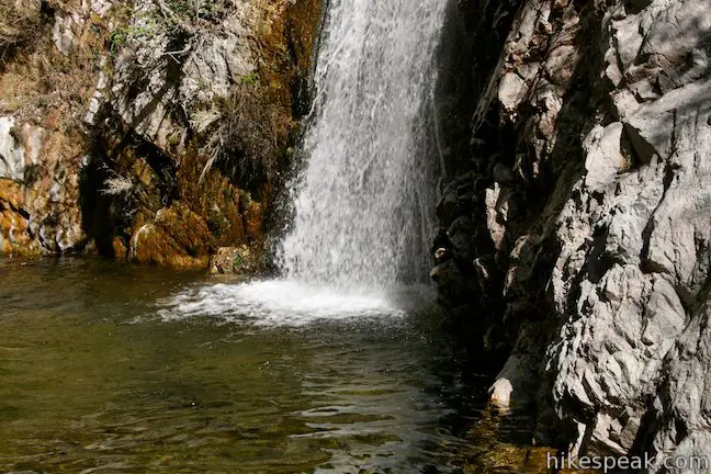
With a bit of maneuvering, one can climb above the pools and follow the creek a bit farther to the base of Switzer Falls. It is worth noting that many hikers do not make it all the way to the waterfall because there is no trail and the creek is tricky to climb.
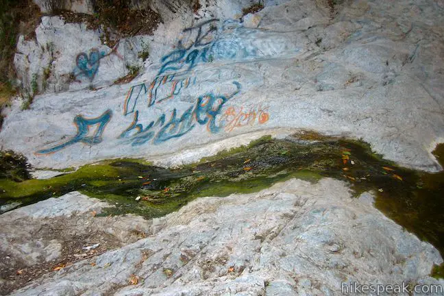
Other waterfalls in the San Gabriel Mountains are easier to access, but this has not seemed to damper the popularity of the hike to Switzer Falls. Unfortunately, the pools beneath Switzer have been tagged with graffiti.
The hike down Gabrielino Trail and Bear Canyon Trail to Switzer Falls is 4.5 miles round trip with 650 feet of elevation change. Dogs and bikes are allowed on this trail in Angeles National Forest. A National Forest Adventure Pass may be required to park at this San Gabriel Mountains trailhead. No hiking permit is needed to visit Switzer Falls, so get out and enjoy!
Directions to the Trailhead
- From the 210 Freeway in La Cañada Flintridge, take the Angeles Crest Highway (CA 2) northwest for 10 miles to the Switzer Picnic Area.
- Descent to the parking lot, display your adventure pass and begin hiking.
- If the lot at the picnic area is full, additional parking is located at the top of the road.
Trailhead Location
Trailhead address: Switzer Truck Trail, Angeles National Forest, Tujunga, CA 91042
Trailhead coordinates: 34.26624, -118.1457 (34° 15′ 58.5″N 118° 08′ 44.5″W)
View San Gabriel Mountains in a larger map
Or view a regional map of surrounding Los Angeles trails and campgrounds.


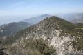
 | Colby Canyon Trail to Josephine Peak This 8.7-mile hike ascends an infrequently visited canyon off Angeles Crest Highway up to a saddle below Strawberry Peak and then takes a wide dirt road up to a summit in the front range of the San Gabriel Mountains with 360-degree over Big Tujunga Canyon and cities to the south. |
 | Strawberry Meadow This 9 to 11-mile hike goes around Strawberry Peak to a remote and scenic flat below a massive cliff on the north side of the mountain, offering views of Big Tujunga Canyon and surrounding peaks along the way. |
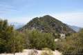
 | Strawberry Peak This 7.5-mile hike to the highest summit in the front range of the San Gabriel Mountains starts out gradual and becomes steep, presenting grand views of surrounding mountains and the cities below. |
 | San Gabriel Peak from Mount Disappointment Fire Road This 6,161 foot peak is reachable via a 4-mile round trip hike from Mount Disappointment Fire Road. |
 | San Gabriel Peak from Mount Lowe Road This 6,161 foot peak is also reachable via a 3.2-mile round trip hike from Eaton Saddle. |
 | Inspiration Point & Mount Lowe Trail Camp This 7.25-mile round trip hike descends Mount Lowe Road into the San Gabriel Mountains to a historic scenic overlook and a trail camp built on interesting ruins. |
 | More trails in the San Gabriel Mountains Explore other destinations in the range. |
 | Fish Canyon Falls This 4.8-mile round trip hike leaves from an active rock quarry and progresses up a beautiful canyon to a mesmerizing multi-tiered waterfall. |
 | Millard Falls This one mile hike visits a 50-foot waterfall up one of the most scenic canyons in the range. |
 | Eaton Canyon Falls This 3.5-mile hike goes up Eaton Wash to a narrow stretch of Eaton Canyon containing a pleasant 40-foot waterfall. |
 | Trail Canyon Falls This 4-mile hike ascends a mountain-framed canyon to a 30-foot beauty on the east side of the San Gabriel Mountains. |
 | Monrovia Falls This 1.6-mile to 3-mile hike in Monrovia Canyon Park follows an enchanting canyon up to the base of the 30-foot waterfall. |
 | Escondido Falls This 3.8-mile out and back hike visits a 200-foot waterfall that is split into two tiers. The upper tier is 150 feet tall and stunning after a rainstorm. |
 | Paradise Falls This 40-foot waterfall is located within Wildwood Park in Thousand Oaks and is reachable via several trails. |
 | More waterfalls around Los Angeles Explore other waterfalls in the Santa Monica and San Gabriel Mountains. |
Common Questions about Switzer Falls in the San Gabriel Mountains
- Is the trail open?
- Yes. You should expect to find that Bear Canyon Trail to Switzer Falls is open. There are no recent reports of trail closures. If you discover that the trail is closed, please help your fellow hikers by reporting a closure.
- Do I need a permit for this hike?
- Yes. National Forest Adventure Pass.
- How much time does this hike take?
- It takes approximately 2 hours 15 minutes to hike Bear Canyon Trail to Switzer Falls. Individual hiking times vary. Add extra time for breaks and taking in the views.
- How long is this hike?
- The hike to Bear Canyon Trail to Switzer Falls is a 4.5 mile out and back with 650 feet of elevation change.
- Are dogs allowed on this trail?
- Yes, dogs are allowed on Bear Canyon Trail to Switzer Falls. The trail is open to hikers, dogs, bikes.
- Will I see a waterfall on this hike?
- Yes, Bear Canyon Trail to Switzer Falls features a waterfall.
- What mountain range is this trail in?
- Bear Canyon Trail to Switzer Falls is located in the San Gabriel Mountains.
- Where is the trailhead located?
- The trailhead for Bear Canyon Trail to Switzer Falls is located in Tujunga, CA.
Trailhead Address:
Switzer Truck Trail
Tujunga, CA 91042
Trailhead Coordinates:
34.26624, -118.1457 - What are the driving directions to the start of the hike?
To get to the trailhead: From the 210 Freeway in La Cañada Flintridge, take the Angeles Crest Highway (CA 2) northwest for 10 miles to the Switzer Picnic Area. Descent to the parking lot, display your adventure pass and begin hiking. If the lot at the picnic area is full, additional parking is located at the top of the road.
View custom Google Maps directions from your current location.
- Are there other trails near Bear Canyon Trail to Switzer Falls?
- Yes, you can find other nearby hikes using the Hikespeak Hike Finder Map.

49 Comments on Switzer Falls in the San Gabriel Mountains
What hikers are saying:
✨ Generated summary of user commentsHikers appreciate this trail for its abundant shade and scenic water features, making it an ideal choice during the hot summer months. However, visitors should exercise caution near the falls, as the pools are often shallow and unsafe for diving or jumping. After heavy rainfall, river crossings can become treacherous, so using trekking poles and waiting for water levels to recede is highly recommended. The route includes narrow, steep sections that require careful navigation to reach the waterfall safely.
“Mostly shade, great place to go during the hot summer.” Jump to comment ↓
where do we purchase parking and how much? Switzer Falls
in the San Gabriel Mountains
There are lots of places to buy adventure passes, like Big 5 Sports, and at a ranger station just up the road from the parking area. More: https://www.fs.usda.gov/detailfull/r5/passes-permits/recreation/
Do you know if this trail is opened now fue to the covid 19?
It’s open as of June 12, 2020
This is my first hike since I discovered Angeles Crest Highway and I was completely satisfied. The trail was not bad at all– I would even say easy-moderate hike. The hardest part was leaving the creek and walking back up the trail–this was only a very short part of the hike. Going to the falls was a lot a fun but slightly tricky. I thought I was at the end but then realized that trail continued. This was the part I enjoyed the most since I was hiking up and meandering up the river hoping from stone to stone. When I finally reach Switzer Falls I was impressed. Very Isolated and clean and I was lucky enough to have it to myself. The water was very clear and refreshing. I definitely recommend this one!
[…] of us went to Switzer Falls on Monday. I figured it wouldn’t be a stroll in the park, but nice trails more or less, […]
Very much enjoyed this hike. Again, goal is to photograph all the waterfalls and did so here. Will probably do this hike again, also, with my Australian Shepherd when he gets a touch older, still a puppy now.
Could someone give directions coming from Long Beach.
710 n. to 5 n. to 2 n. to Switzer Falls Gate, on your right hand side.
are there any snakes?
Yes there are snakes.
I believe posted online say gates close @ 6pm. They close typically just after 5pm. once in you can always get out. Beautiful Hike yesterday (7/21/13)….
Well that’s good to know haha I would not like to be stuck unprepared.
What time do the gates of switzer falls close? i just dont want to get stuck walking the big hill:)
Adventure pass still required? And per party or each individual needs one?
thanks.
According to this National Forest webpage, an adventure pass is still required to park at the Switzer Picnic Area. You will need one pass per vehicle.
could you purchase a parking pass on site?
You can purchase an Adventure Pass from the Clear Creek Ranger Station, which is along Angeles Crest Highway about half a mile before the turn for Switzer Picnic Area.
I am planning a family day hike with parents/children from school. The group could be as large as 30 people. Would you recommend Switzer Falls to be the right type of hike for a large group with children?
This trail to Switzer Falls has narrow, steep sections and it’s a bit of a challenge to reach the waterfall. I would recommend Eaton Canyon Falls for a large group with children. Most of the trail is wide and easy, and there is a large area below the waterfall for everyone to gather.
Do you need an adventure pass for this hike? How much are they? I’m planning to hike where there’s beautiful waterfall with my boyfriend this Spring Break. We’re from Hawai’i and don’t want to get lost along the way or go alone really. I would like to go somewhere with a few people and not too dangerous. Any suggestion would be great.
[…] highly recommend a hike to Switzer Falls to introduce you to Angeles National Forest, followed by lunch at Newcomb’s Ranch – a […]
Just hiked to Switzer Falls today for the first time this year. Despite some rains this year the water level was low, still flowing, but low. I can remember 5+ years ago having a wide creek to navigate and a pool of water at the base of the falls… now it’s simple to step over the creek, and the though the waterfall is flowing, it lands in sand and becomes the creek. Here’s hoping we see an end to the drought soon.
Hiked to the base of the upper fall yesterday. I was so disappointed. I’ve been there 5 times previously (last in the mid-90’s) and loved the swimming holes and rock slides. Now all the falls and cascades dump onto sand that has filled the pools (5 that I use to visit). Fire and drought have heavily affected this beautiful little canyon.
Hoomans dug those pools. First by local natives. Then maintained by hippies. Most recently, by myself and a friend. Cannot do it alone anymore and apparently no-one is interested in helping with restoration..
Manwolf
At a moderate pace, how much time should be allowed for the round trip? I am trying to figure out how early in the day I should start out.
2-3 hours should be plenty of time to enjoy this hike.
Coming from Palmdale…how far is the location
Since there were fires in that area, is Switzer Falls open. Is there a waterfall there. Due to the water drought.
is there still water during this time? what time do they close and how much are passes?Im planing on going today.
As of 18 March 2018 the “tagging” or graffiti has been
Handled due to a vigilant Forest Service Volunteer.
Enjoy your hike ditraction free.
My last 2 trips here in 2015 and 2016 I found that one of the deepest pools that was close to 8ft deep was full the brim with dirt and gravel. My scouts were bummed. I’m guessing slide and run off is what filled it in. In your experience would the forest service allow scouts to volunteer and to dig it out?
The pool of which you refer was ten feet deep in June. I am the one who caretook this canyon. It got to be too much for me and an occasional assistant. Am planning “Closeouts” in November and will appreciate any assistance.
Hey there some friends and I would love to help clean up the area if you’re organizing anything please let me know so we can help out!
This is a good time of year for clean up. There is also a considerable amount of non-native plant removal needed. Was exceptional water flow in June. Trying to get back up there to do what is called “Close Outs.” Which is streambed debris removal and erosion control for winter high water flow.
I go by my name on social media. Friend me and let’s see what we can put together!
Is there still swimming here? What’s the water quality? Just a little Oregonian missing swimming in watering holes….
Hannah,
I’ll be down to check this out. I’m also an Oregonian (been here since April) missing home.
This used to be a nice place years ago. Now it’s overcrowded with people, boom boxes, alcohol and men pissing on trees. If you want a real hike and nature experience, this isn’t it.
Can u get in the water here? Do people swim? Is there any rock jumping?
What year was the most recent fire in the area?
The Station Fire did a lot of damage around this area in 2009.
We loved Switzer fall it was very beautiful, lots of trees and water. It took us 2 hours in and out. I found it very beautiful and mostly shade, great place to go during the hot summer. I plan to go again
does anyone know if we need reservation to hike this trail
Was there ever a castle there?
Hi, I just saw your question after going through some old family photos taken in 1931. I ran across a picture of what looked like a monastery or church and discovered that it was at Switzer’s. A site called The Hiker Guy mentions a chapel. That may be the “castle” you are asking about. https://hikingguy.com/hiking-trails/best-la-hikes/switzer-falls-hike/ “The chapel was built in 1924 and included a pipe organ and stained glass windows, all hauled up the cliff by hand. The chapel held 200 people and was a popular wedding destination. You can hike up to the ruins from the trail above the upper falls. It’s about a 200ft scramble but it’s doable.”
[…] you’d like to make it a full day in the mountains, the Switzer Falls trailhead is also located just off this route at the Switzer Falls Picnic area. The 4.5-mile […]
Caution: After the recent rain, the river crossings that were once easily doable by families and children are now either entirely submerged or torrential rapids over deep pockets of water. The trail next to the river during the early part of the hike has been turned into another tributary. Even as experienced hikers with trekking poles, we couldn’t make it more than 15 minutes in before we were forced to turn around bc of the dangerous conditions. Wait until water level decreases before attempting if you plan on doing the full hike.
Back in the late 1970’s I worked in the ER at Verdugo Hills Hospital. One day we got a call that a Sheriffs helicopter was bringing in someone injured at Switzer Falls. I went out with a gurney to meet it and the paramedic on board was Jim Shea, a fellow Special Forces Medic I had been in the Army with. This wasn’t my first Switzer patient. From what I’ve been told the water at the base of the falls is not very deep AND IT HAS A BOTTOM TO IT. So please don’t jump or dive off the cliff into the pool.
[…] Switzer Falls: One of the region’s most popular waterfall hikes, Switzer Falls will be looking particularly great after our recent rains. Seize the opportunity to enjoy the 4.5- mile there-and-back hike, which will reward you with impressive sights and a truly out-of-the-city experience, even though you haven’t gone far […]