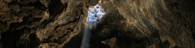
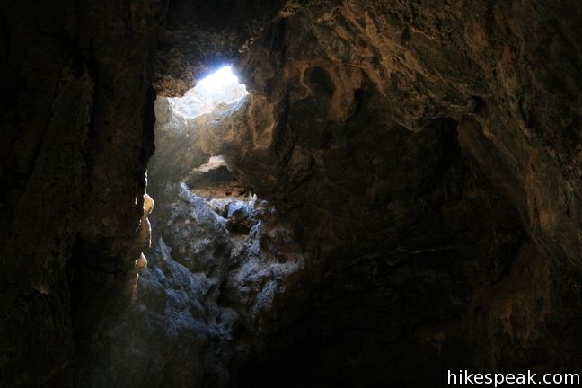
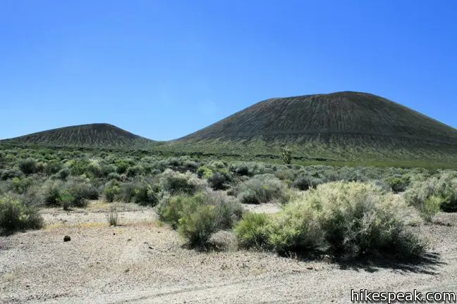
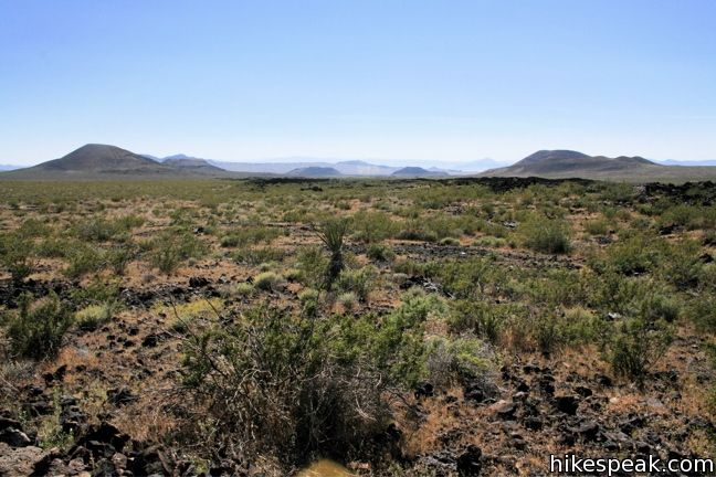
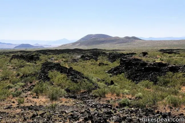
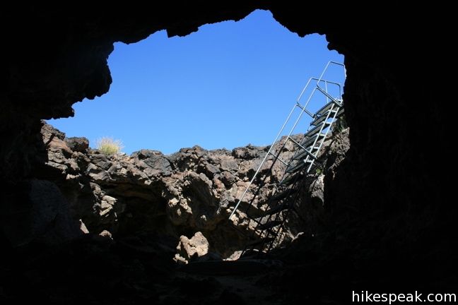
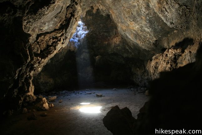
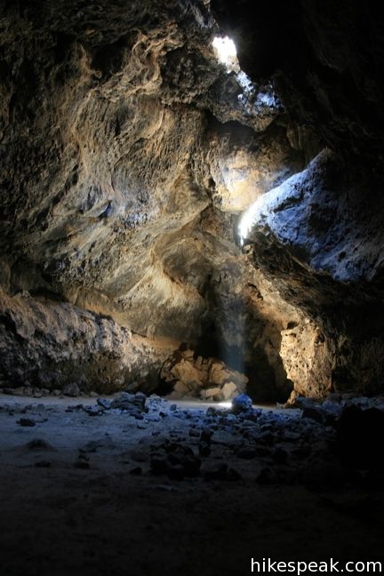
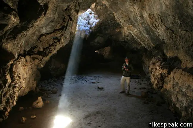
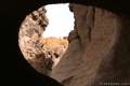
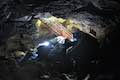
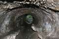
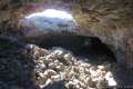
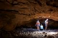
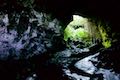
A field of cinder cones stands out dramatically from the surrounding Mojave Desert between the city of Baker and Kelso Depot Visitor Center in Mojave National Preserve. Within the lava field is a short trail leading to a tube formed long ago by molten lava. A ladder takes hikers down into the tube where skylights (holes in the rock ceiling) illuminate a subterranean world.
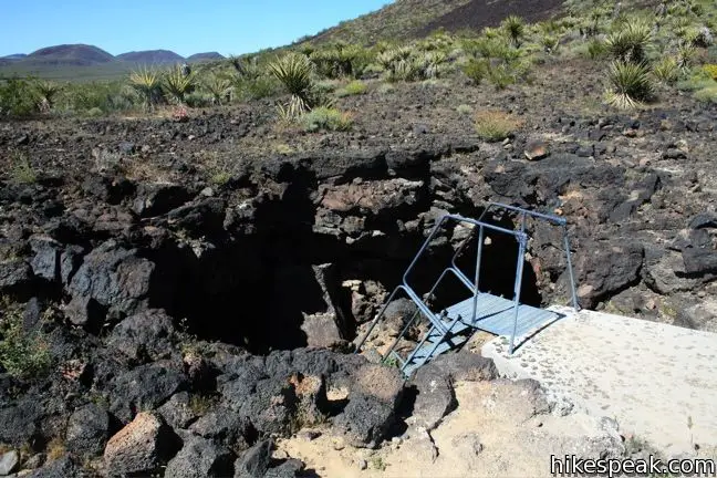
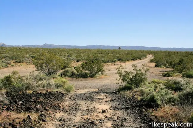
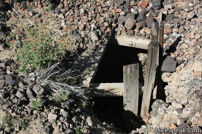
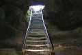
From the trailhead, hike 0.18 miles up a rough jeep trail. Turn right at the first junction onto a single-track trail, and continue 0.1 miles past two holes in the ground to the tube entrance. An impressive metal ladder has been cemented in place to enable access to the tube below.
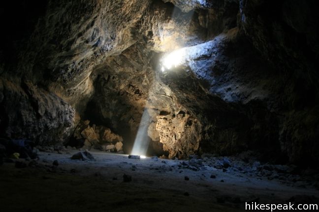
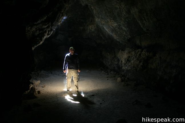
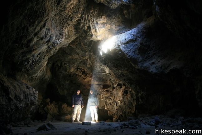
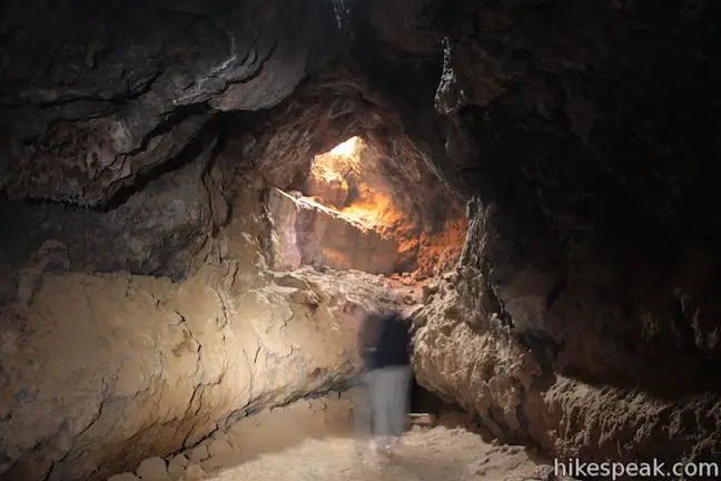
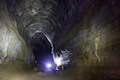
Descend the metal steps and turn left, climbing down boulders that once made up the ceiling of the tube. Beyond the boulders, the bottom of the tube is flat and dusty. Make your way beneath a low hanging ceiling and enter the main chamber. A flashlight is a handy thing to have through this dark crossing.
The ceiling rises and the tube opens up on a shadowy room exposed by a spotlight of sunlight. The chamber is only a couple hundred feet long, but is a place worth lingering in. Explore the walls of dark hardened lava and take pictures in the dramatic lighting. As an added bonus, the lava tube is a great place to escape the heat up on the desert surface.
Mojave National Preserve does not change an entrance fee and no permit is required to hike Lava Tube Trail, so get out and enjoy!
Directions to the Trailhead
- From Kelso Depot Visitor Center, head west 15 miles on Kelbaker Road.
- Turn right on the unmarked Aiken Mine Road (the turnoff is 19 miles form Baker for those coming in the opposite direction).
- Drive north on Aiken Mine Road past water tanks, corrals, and cinder cones.
- Take it slow over this rough road, which should be passable for most vehicles.
- After 4.5 miles, turn left at a fork in the road, following a sign for the lava tube.
- Drive another quarter mile to the parking area at the trailhead.
Trailhead Location
Trailhead address: Unnamed Road off Aiken Mine Road, Mojave National Preserve, CA 92309
Trailhead coordinates: 35.21378, -115.7532 (35° 12′ 49.6″N 115° 45′ 11.5″W)
You may also view a regional map of surrounding California Desert trails and campgrounds.


 | Kelso Dunes This 3-mile round trip hike climbs 470 feet to the highest point in this 45 square mile dune field. |
 | Lava Tube This short 0.6-mile hike drops below the surface into an old lava tube. |
 | Teutonia Peak This 3.4 to 4-mile round trip hike crosses the world's densest Joshua tree forest, passing an abandoned silver mine to reach a rocky summit with views of Cima Dome. |
 | New York Peak This 7 to 9-mile round trip hike summits the highest point of the New York Range in the northeast corner of the preserve. |
 | Rock Spring Loop Trail This 1 1/3-mile loop visits a rare desert spring, a Rock House built in the 1920s, a miners' mill site, and an old U.S. Army post on a short and scenic circuit. |
 | Hole-in-the-Wall Rings Trail This 1.5-mile loop takes visitors through a landscape of pocketed rocks. Ringbolts allow fun passage through narrow canyons. |
 | Fountain PeakThis 5-mile off trail trek summits a peak with commanding views over the Providence Mountains. |
 | Silver Peak This 8.5-mile hike summits a 6,365-foot peak in the Granite Mountains. |
 | Amboy Crater This 3-mile round trip hike travels up and into this crater adjacent to Mojave National Preserve. |
 | Hikes in the California Desert Explore more trails in Death Valley National Park, Joshua Tree National Park, Anza-Borrego Desert State Park, and Mojave National Preserve. |
 | Lava River Cave in Newberry National Volcanic Monument (Oregon) This underground hike explores a lava tube south of Bend that is filled with fascinating volcanic features. |
 | Guler Ice Cave in Gifford Pinchot National Forest (Washington) This short hike goes underground to explore an old lava tube with frozen stalactites and stalagmites, plus other interesting cave features. |
 | Trail of Two Forests in Mount Saint Helens National Volcanic Monument (Washington) This short nature trail tours a landscaped that was transformed by a molten lava flow. For extra fun, crawl through a 50-foot long lava tube beneath the trail. |
 | Ape Cave in Mount Saint Helens National Volcanic Monument (Washington) This adventurous underground hike travels through one of the longest lava tubes in the world. |
 | Caves Trail in Crates of the Moon National Monument (Idaho) This 1.6 mile travels above and below the surface, exploring lava tubes in the Great Rift Lava Flow. |
 | Kalahuipua'a Trail and Fishponds Loop (Hawaii) This action-packed 1.7-mile hike explores a lava field with a lava tube shelter and impressive fishponds along a gorgeous coastline. |
 | Kaumana Caves (Hawaii) This underground hike explores lava tubes on the edge of Hilo, created by an 1881 eruption of Mauna Loa. |
 | Mojave National Preserve There are a few campgrounds and endless roadside camping within the preserve. |
- A great Lava Tube handout by the NPS (opens in a new tab)
- Lava Tube on birdandhike.com (opens in a new tab)
- Lava Tube in Mojave National Preserve on californiathroughmylens.com (opens in a new tab)
- Lava Tube in Mojave National Preserve on weekendsherpa.com (opens in a new tab)
- Lava Tube Trail In Mojave National Preserve on trailtopeak.com (opens in a new tab)
- Lava Tube in Mojave National Preserve on bonjourbecky.com (opens in a new tab)
- Lava Tube in Mojave National Preserveon outdoorsocal.com (opens in a new tab)
- Lava Tube in Mojave National Preserve on roadtripryan.com (opens in a new tab)
- The official webpage for Lava Tube in Mojave National Preserve (opens in a new tab)
- The official website for Mojave National Preserve (opens in a new tab)
Common Questions about Lava Tube in Mojave National Preserve
- Is the trail open?
- Yes. You should expect to find that Lava Tube Trail is open. There are no recent reports of trail closures. If you discover that the trail is closed, please help your fellow hikers by reporting a closure.
- Is this trail free to access?
- Yes, Lava Tube Trail is free to access. No entrance fee, pass, or permit is required. If you discover that access rules have changed, please provide feedback on your experience.
- How much time does this hike take?
- It takes approximately 15 minutes to hike Lava Tube Trail. Individual hiking times vary. Add extra time for breaks and taking in the views.
- How long is this hike?
- The hike to Lava Tube Trail is a 0.6 mile out and back with 150 feet of elevation change.
- Are dogs allowed on this trail?
- Yes, dogs are allowed on Lava Tube Trail. The trail is open to hikers, dogs.
- Is Lava Tube Trail good for kids?
- Yes, this hike is likely suitable for children. It is relatively short (0.6 miles) with manageable elevation gain.
- Are there caves on this hike?
- Yes, Lava Tube Trail features caves to explore.
- Does this hike visit a lava tube?
- Yes, pack a headlamp to check out the lava tube on your trek to Lava Tube Trail.
- Where is the trailhead located?
- The trailhead for Lava Tube Trail is located in Mojave National Preserve, CA.
Trailhead Address:
Aiken Mine Road
Mojave National Preserve, CA 92309
Trailhead Coordinates:
35.21378, -115.7532 - What are the driving directions to the start of the hike?
To get to the trailhead: From Kelso Depot Visitor Center, head west 15 miles on Kelbaker Road. Turn right on the unmarked Aiken Mine Road (the turnoff is 19 miles form Baker for those coming in the opposite direction). Drive north on Aiken Mine Road past water tanks, corrals, and cinder cones. Take it slow over this rough road, which should be passable for most vehicles. After 4.5 miles, turn left at a fork in the road, following a sign for the lava tube. Drive another quarter mile to the parking area at the trailhead.
View custom Google Maps directions from your current location.
- Are there other trails near Lava Tube Trail?
- Yes, you can find other nearby hikes using the Hikespeak Hike Finder Map.

25 Comments on Lava Tube in Mojave National Preserve
What hikers are saying:
✨ Generated summary of user commentsThis trail offers a speechless experience as visitors descend into a subterranean world of ancient lava and dramatic light beams. The access road is heavily washboarded and contains deep sand, requiring careful driving to avoid getting stuck. Brett advises caution in the sandy sections where vehicles can easily lose traction. Explorers should bring a headlamp to safely navigate the sharp rocks and low overhead clearances within the tube.
“Super cool to see all that lava in the middle of the desert!” Jump to comment ↓
[…] protected by the National Park Service. Our first stop of the morning is shown above. We explored a lava tube in the cinder cones portion of the preserve. We descended into the dark tunnel by the steps above, and then studied the walls and ceiling with […]
Watch your head if not wearing a helmet (:
Can this site and Amboy be visited on the same day? Any camping overnite?
Yes you can visit both in the same day and camp in Mojave National Preserve.
Do you need offroad to get to the trailhead?
It definitely helps to have a high clearance vehicle, but in the past this road has been in pretty good shape for a road in Mojave. I’ve been a few times in hatchbacks/sedans and made it up the road OK driving carefully. The last time I went the road was the worst it’s been, but I think the park does try to keep the road maintained.
So is it a dirt road or an unmaintained road that has eroded?
It is definitely doable, but be careful with the sand. I got stuck yesterday and spent two hours digging myself out with my bare hands.
Hikespeak was an excellent resource to help me find some of the hidden gems of the Mojave. Here is a 2 minute short film showing some of the places I visited on the first of many trips to come.
https://vimeo.com/90922323
A great adventure, went camping here for 2 days on May 2015 with my wife, we went down the lava tube and took my headlamp although it was noon and shiny day the headlamp was useful under the ground, careful with the overhead and some sharp rocks in the entrance.a speechless experience. from the pictures above the small hole with old wood around seemed to have collapsed and is no longer accessible. hiked up one of the nearest mountains (dome) later that night and was an extreme experience unforgettable, clear sky and beautiful view of the stars at night. during our time there we came across some wild rabbits, lizards
some rodents that seem to stand up and big white spiders that seem to come out at night. I am wondering if hunting is permitted inside the Preserve?.
Those rodents that “stand up” are kangaroo rats. Their hind feet are oversized and shaped like a kangaroo’s do they can hop like kangaroos and jack rabbits do. Love them!
I was just there yesterday 6/4/16 and the main area is collapsed. Your can make it a like 20-30 feet from the ladder and that’s it. There’s rock rubble everywhere and the floor is a lot more filled in. Looks like the rains we had this past winter may have done the tube in
That is terrible news!
Ok. I may have been quick to judge. Last time I was out there was a bit over 10rs ago. I just saw some of the recent youtube videos and it looks like it did when I visited. I’m going to have to go back to check it out again in a few weeks and report back.
When is the best time of day to photograph the light tube? Is it OK still? Are we able to accessit?
Hello, I was curious if anyone knew of a place in the Mojave, Death Valley, or Monument Valley that resembles a Basalt formations similar to that of Giant’s Causeway? The reason I ask is cause two years ago I made a trip across the US. I came to this place there I thought the road led me into a dead end monument style formation, shaped like a question mark. Going into this place I noticed the rocks were of a thin column style arrangements, broken pieces littered the entire floor. When you get to the other side of the monument you go through a stone arch. Does anyone know where this is? The Road number would be great. Thanks.
Devils postpile has hexagonal basalt formations as seen in giants causeway, it is near mono lake.
With the sun so low in the sky in november is there a good time of day to enjoy the sun rays angling into the tube? I would assume noon is probably optimal. Any recent visitors to confirm this? I will be out there with my son over Thansgiving.
How’d it go?
Just visited. It’s definitely all still accessible as far as I can tell. We took a little sedan on that dirt road and while I never felt like we were in danger of being stuck it was pretty badly washboarded, the whole drive was about 10-12 MPH. Also the light in the winter is pretty great still but the beams hit the walls pretty high up due to the sun’s angle. If you want the vertical beams like the pictures you’ll need to go closer to June.
Just visited the tube, looks like the right side might have collapsed many years ago but the ladder is still there and all the pics you see above is exactly what it’s like. The dirt road to get there is rough and I had an suv so we averaged about 15 mph but we saw a sedan there so they made it. The hike is like 5 min. Super cool to see all that lava in the middle of the desert!
Is there a hotel near the light tube we can stay at?
What time can I get the light tube in July?
Thanks for this! Your post and GPS coordinates got me there ??
[…] Lava Tube is located about 5 miles off of Hwy 63. The top of the lava tubes (or simply “Lava Tube” as it’s commonly referred to) is only accessible via a 5-mile dirt road. Three holes in the ceiling of the lava tubes allow sunlight to shine beneath the cave floor. […]